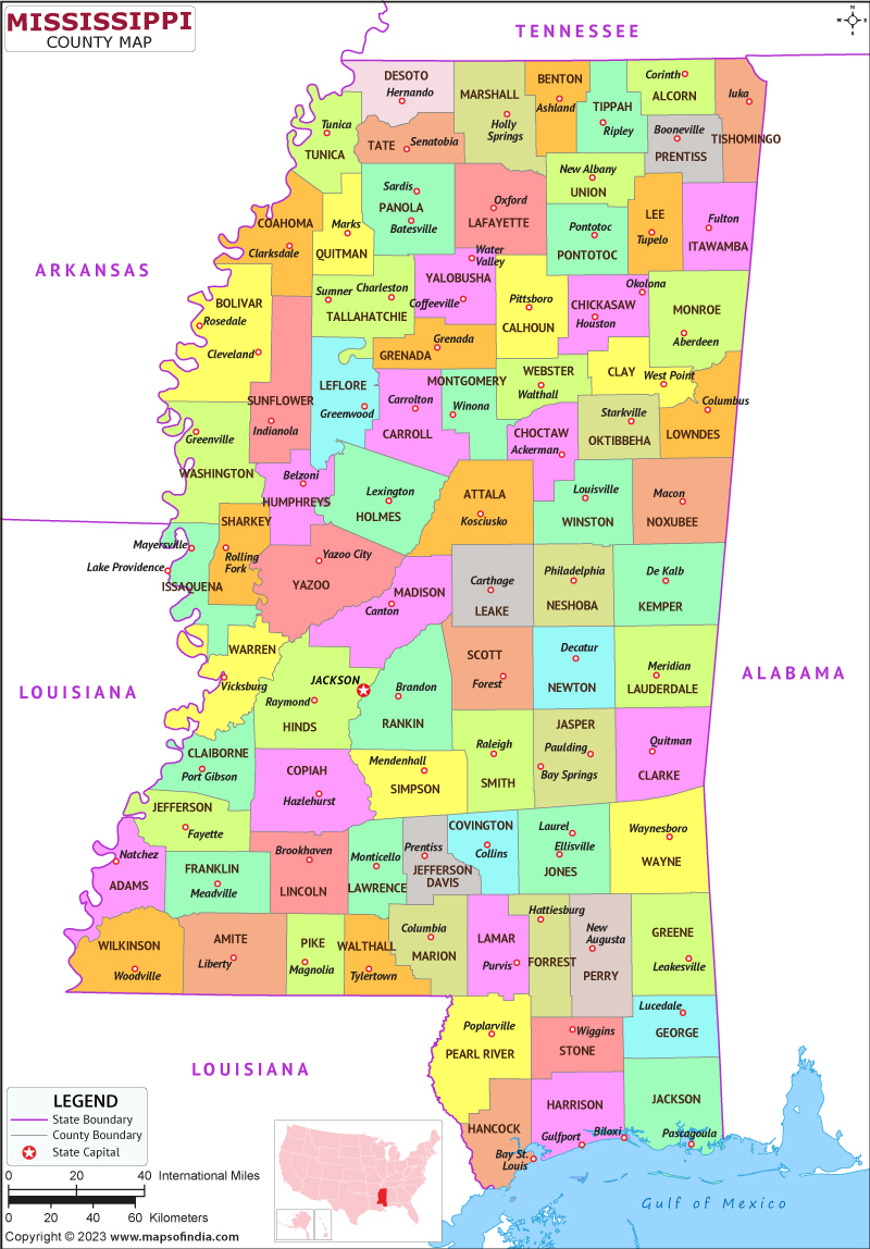
Mississippi is a state of the United States situated in the southern portion. It is the 32nd largest state by geographical area and the 34th most populous state with a population of approximately 3 million people. The capital city is Jackson and the largest city is Gulfport.
History
Mississippi has a long and Complicated history, with Numerous Native American tribes including the Choctaw, Natchez, and Chickasaw people living in the area for thousands of years before the advent of Europeans. The first European explorers to visit Mississippi were Spanish in the early 16th century, followed by the French and British. The state played a pivotal role in the American Civil War, with battles fought throughout the state. Mississippi was also a center of the Civil Rights Movement, with major events including the 1962 Ole Miss riots and the 1963 assassination of civil rights leader Medgar Evers.
Culture
Mississippi has a prosperous and vibrant culture, influenced by its Native American, African American, and European heritage. The state is known for its music, with blues, gospel, and country music all having deep roots in Mississippi. The state is also home to numerous museums and cultural institutions, including the Mississippi Civil Rights Museum and the Mississippi Museum of Art. Mississippi is also known for its cuisine, with dishes like fried catfish, gumbo, and crawfish étouffée popular throughout the state.
Language
Mississippi's major language is English, although the state contains a sizable community of people who speak various languages, notably Spanish and Vietnamese. Mississippi has a longstanding experience of multilingualism and has made attempts in its schools and communities to encourage multilingualism and ethnic diversity.
Geography
Mississippi is situated in the south central portion of the United States and is surrounded by Louisiana to the southern front, Alabama to the eastern front, Tennessee to the northern front, and Arkansas to the western front. The state is known for its diverse geography, with the Mississippi River running along its western border and the Gulf of Mexico to the south.
| Official Name | Mississippi |
| Capital | Jackson |
| Area | 125,443km2 |
| Population | 29.6 Lakh |
| Language | English |
| Religion | Christianity |
| Admitted to the Union | December 10, 1817 |
FAQs
Q1: What is the state flower of Mississippi?
Mississippi's official flower is the magnolia, a huge blooming tree with beautiful white blossoms that blooms in the spring.
Q2: What is the oldest city in Mississippi?
Natchez, the state's oldest city, was established by the French in the year 1716 and functioned as an important hub of trade and business during the eighteenth and nineteenth centuries.
Q3: What is the significance of the Mississippi River to the state?
The Mississippi River has played a significant role in the history and culture of Mississippi, serving as a major transportation route for goods and people throughout the state and the wider region. The river has also been a source of inspiration for writers and artists, with authors like Mark Twain and musicians like B.B. King drawing inspiration from its waters.
Q4: What is the role of agriculture in Mississippi's economy?
Agriculture is a major component of Mississippi's economy, with the state producing a wide range of crops including cotton, soybeans, and sweet potatoes. The state is also a significant producer of poultry, eggs, and catfish. Agriculture and related industries provide employment for a significant portion of the state's population and contribute significantly to its overall economic output.
Last Updated on: August 23, 2023
