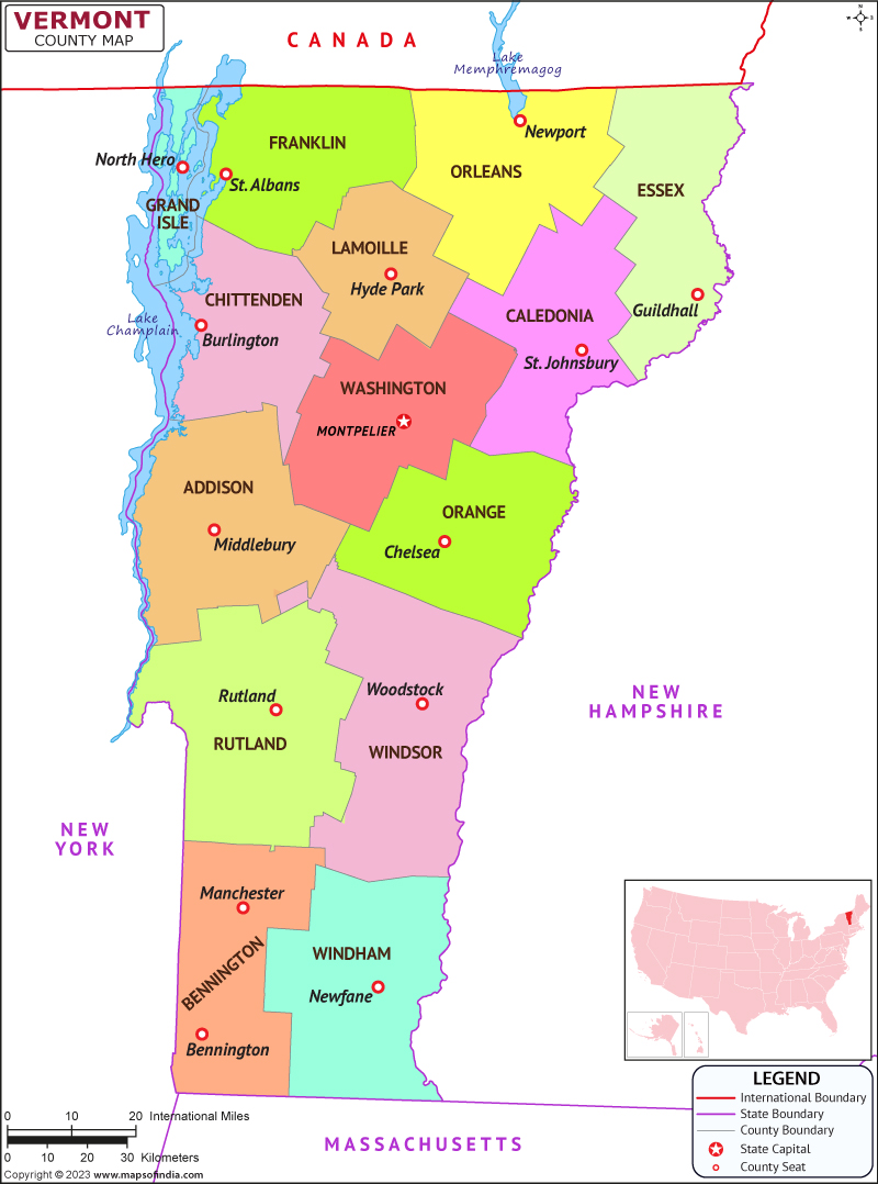
Vermont is a state situated in the northeastern portion of the US. It is the second smallest state in terms of population and the sixth smallest state in terms of geographic area. Vermont is known for its scenic beauty, picturesque villages, and vibrant local culture. The state has a rich history and a unique culture that is influenced by its geography, natural resources, and diverse communities.
History
Vermont was originally inhabited by various indigenous tribes, including the Abenaki, Mohawk, and Iroquois. The first European settlers arrived in the early 17th century and established a trading post near Lake Champlain. In 1777, Vermont declared independence from the British Empire and became the first state to do so. However, it was not until 1791 that Vermont officially became a state of the United States.
Vermont played an important role in the abolitionist movement and was a major center for the Underground Railroad. During the Civil War, Vermont contributed a large number of soldiers to the Union Army and was known for its strong anti-slavery stance. In the 20th century, Vermont became a leader in progressive politics and environmental conservation.
Culture
Vermont is known for its strong sense of community and its commitment to local values. The state has a thriving arts scene and is home to numerous music festivals, art galleries, and theaters. Vermont is also famous for its food culture, with a focus on locally sourced ingredients and traditional New England cuisine. Maple syrup is a particularly important product in Vermont, with the state producing over 40% of the world's supply.
Language
The primary language of the state is English. However, the state has a diverse population, and many residents speak other languages, including French, Spanish, and various indigenous languages.
Geography
Vermont is situated in the northeastern portion of the US and is surrounded by New York to the western front, Massachusetts to the southern front, New Hampshire to the eastern front, and the Canadian province of Quebec to the northern front. The state has a diverse geography, including mountains, forests, lakes, and rivers. The highest point in Vermont is Mount Mansfield, which reaches a height of 4,393 feet.
| Official Name | Vermont |
| Capital | Montpelier |
| Area | 25,443km2 |
| Population | 6.4 Lakh |
| Language | None |
| Religion | Christianity |
| Admitted to the Union | March 04, 1791 |
FAQs
Q1: What is Vermont's most famous food?
Vermont is known for its maple syrup, which is a major export of the state. Other popular foods in Vermont include cheddar cheese, apple pie, and cider donuts.
Q2: What is the climate like in Vermont?
Vermont has a humid continental climate, with moderate summers and intense winters. The state experiences heavy snowfall in the winter months, particularly in the mountainous areas.
Q3: What are some popular tourist attractions in Vermont?
Some popular tourist attractions in Vermont include the Ben & Jerry's ice cream factory, the Shelburne Museum, and the Vermont Teddy Bear Company.
Q4: What is Vermont's state flower?
The state flower is the red clover, which is a symbol of the state's agricultural heritage. The red clover is a common wildflower in Vermont and is also grown as a crop for hay and pasture.
Last Updated on: July 07, 2025

