Massachusetts Map | MA State Map

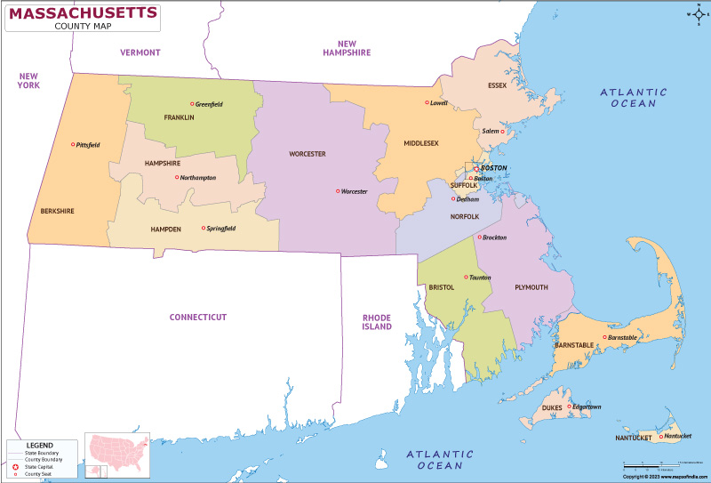
Map of Massachusetts (MA) State

Click here for Customized Maps arrow custom map
Massachusetts map showing state counties
Email Tweet this map   Buy Now
*Massachusetts map shows all the counties along with state capital.

Disclaimer: All efforts have been made to make this image accurate. However Mapping Digiworld Pvt Ltd and its directors do not own any responsibility for the correctness or authenticity of the same.

Massachusetts is located in the northeastern United States, as illustrated on the massachusetts map and It greatly contributed to the American Revolution. Boston and Lexington are some key sites in fighting for the country's independence in the nation's fight. The name "Massachusetts" is derived from the Massachusett people, an Algonquian Native American tribe that lived in the region. The name comes from their word Massachusett, which is translated to mean "near the great hill" or "at the great hill," probably referring to the Blue Hills near Boston.


History


The history of the region began long before the actual European settlers. The various Native American tribes that inhabited it named the region. This was mostly populated with the Massachusett people. The early 1600s saw the first European explorers in the region with promises of new resources and opportunities. In 1620, the first actual group of English Puritans, who later became the Pilgrims, landed at Plymouth Rock with hopes of finding religious freedom and setting up a colony. The Pilgrims, aboard the Mayflower, signed the Mayflower Compact, a governing document that laid the foundation for self-government in the New World. In 1630, John Winthrop and the Massachusetts Bay Company arrived in the New World with the second wave of settlers.

This made the Massachusetts Bay Colony one of the first successful Puritan settlements and soon attracted other settlers who sought religious freedom. With time, conflicts began to develop between the Puritans and other religious groups, which resulted in the formation of new colonies like Rhode Island by dissenters such as Roger Williams. The colony became an important port in the transatlantic trade, including the trade of rum, molasses, and slaves, which contributed to the rise of a wealthy merchant class. As the colony prospered, tensions with England began to mount, particularly over issues like taxation without representation.

The colonists grew increasingly restless by the mid-1700s. Taxes such as the Stamp Act in 1765 and the Townshend Acts in 1767 led to general protests. In 1770, British soldiers killed five colonists in the Boston Massacre. The famous Boston Tea Party in 1773, where colonists dumped tea into Boston Harbor protesting the Tea Act, increased tensions. It soon burst into the outbreak of the American Revolutionary War in 1775; this was after several military confrontations between British forces and colonial militias were experienced at Lexington and Concord, which marked the starting point of a new country that would become part of the United States.

It was a central component in forming the early government of the nation with leaders like John Adams, Samuel Adams, and John Hancock taking the leading role in the pursuit for independence. During the 19th century, the state expanded further when the Industrial Revolution introduced new factories, railroads, and technology into the system. Massachusetts became a power house of industry in the textile line, but at the same time a center of abolitionist activity, the movement fighting slavery.


Culture


Due to being the spot of the landing of the Mayflower in 1620 and hosting the very first successful Puritan settlements along with the great events of the American Revolution, Massachusetts is actually seen as a state that harbored the independence of America. Its Freedom Trail, located in Boston (visible on the massachusetts map), provides visitors with opportunities to witness historical locations, such as the Massachusetts State House, Paul Revere's House, and the Old North Church, connected under one chain.

It is also known for its contributions to arts and literature. Boston has always been a place for writers, philosophers, and intellectuals, and the names of Ralph Waldo Emerson, Henry David Thoreau, and Nathaniel Hawthorne are added to the literary heritage of the state. There are innumerable museums and galleries, like the Museum of Fine Arts in Boston, with an impressive collection of various periods and cultures.

The cuisine of Massachusetts can be said to depend mainly on its geography in that it is coastal and has heaps of seafood, mainly shellfish. It is usually centered on clam chowder, lobster rolls, and baked beans. Fresh seafood is what Cape Cod, the North Shore, and Boston Harbor are known for. The people, and visitors, just love them. Boston itself claims a lot of fun food markets such as an old Quincy Market where New England fare blends international dishes. Several festivals and other events throughout the year also support the richness in cultural atmosphere over the state.

The Boston Marathon is one of the oldest marathons and the most popular in the world, held every year on Patriots' Day in April, and it attracts thousands of participants and spectators. The Boston Arts Festival and the Lowell Folk Festival feature local arts and crafts, but the Saint Anthony's Feast in Boston's North End celebrates Italian heritage with food, music, and street parades. And, of course, the state's connection to its Irish-American heritage is celebrated through St. Patrick's Day, which is held throughout the state but particularly in Boston, which holds one of the largest Irish festivals in the United States. Massachusetts also prioritizes education and intellectual life. The state boasts world-class universities like Harvard University and the Massachusetts Institute of Technology, well known both within the world community for their contributions toward higher education, research, and innovation.


Language


Massachusetts is one of the most linguistically diverse states as most residents speak English, followed by others like Spanish, Portuguese, Chinese, Haitian Creole, and Italian. The three language groups that account for the biggest shares of local languages spoken today are Spanish; Portuguese, widely represented due in large part to Portuguese-speaking immigrant groups from such places as Brazil and the Azores; and Chinese, of which Mandarin and Cantonese together comprise a couple of distinct spoken forms. Several neighborhoods reflect Massachusetts' growing population of Chinese ancestry as does much of Boston (visible on the massachusetts map).

Also often heard is Haitian Creole, spoken by the Haitian community, more so in the cities of Boston and Brockton, which house large Haitian populations. Italian, though far less commonly spoken today than earlier, still finds a presence within certain parts of the state, especially in the Boston metropolitan area, due to historical Italian immigration.


Geography


The coastline along the Atlantic Ocean of Massachusetts is immense, measuring more than 1,500 miles of shoreline if including its numerous islands and inlets. Coastal areas are marked by sandy beaches, marshlands, and rocky cliffs. Among the most famous areas along the coastline is Cape Cod, a hook-shaped peninsula stretching out into the Atlantic.

The North Shore stretches from the Massachusetts-New Hampshire border down to Boston and is known for its charming seaside towns and beautiful beaches, including those at Marblehead and Rockport. The South Shore, stretching from Boston down toward the Rhode Island border, also features scenic coastlines, with the islands of Nantucket and Martha's Vineyard being some of the most notable. These islands are popular for their rural beauty, wildlife, and coastal charm, making them top destinations for vacationers.

The Connecticut River is the lengthiest river crossing the western frontier of the state, being that important water artery for transportation, trade, as well as offering fertile soil where agricultural products within the Connecticut Valley can be efficiently cultivated.

The Berkshires divide the middle and western parts, stretching into western Massachusetts with parts in New York and Connecticut. The Berkshires are surrounded by dense forests, winding rivers, and numerous lakes. Mount Greylock, standing tall at 3,491 feet as the state's highest peak, is located here. Being a cultural center, the Berkshires host a variety of art museums, theaters, and festivals throughout the year.

The Pioneer Valley is situated along the Connecticut River in western Massachusetts, and home to the cities of Springfield and Northampton. It was one of the earliest areas in New England settled by Europeans, and many historic sites and museums dot the region, reflecting its colonial past.

The state has a number of national and state forests, such as the 12,000-acre Savoy Mountain State Forest in the Berkshires and the much larger Massachusetts State Forest in the central part of the state. These forests are home to a variety of wildlife, including deer, moose, and a variety of bird species, and they provide outdoor recreational opportunities such as hiking, camping, and birdwatching.

Aside from these, the state contains several thousand lakes and ponds-most are situated along its western shore. These range in size and notable examples of big lakes and small lakes comprise of Quabbin Reservoir-a reserve source for water supplies around the metropolitan city of Boston (visible on the massachusetts map); as well as Walden Pond-one famous as associated with essayist Henry David Thoreau.

Massachusetts has a temperate climate, having four distinct seasons: cold winter, mild spring, warm summer, and crisp autumn. Areas along the coasts tend to have milder winters and cooler summers, and inland areas have colder winters, often with more snow, and warmer summers. During summer, it can reach temperatures of 26-32°C, but in coastal areas, sea breezes from the Atlantic often temper this heat.


Quick Facts (From the Massachusetts Map)

Official nameMassachusetts
CapitalBoston
Total Population 7,136,171
Total Area27,363 km2
GovernorMaura Healey
LanguageEnglish


FAQs


Q1: What are the major cities?


The capital and largest city is Boston (visible on the massachusetts map), which has been historically significant in the American Revolution. Other major cities include Worcester, Springfield, Cambridge, and Lowell (also visible on the massachusetts map).


Q2: What is Massachusetts known for today?


Nowadays, Massachusetts is renowned for being home to such excellent institutions like Harvard and MIT that make it a center for worldwide education and innovations.


Q3: Is it safe to visit?


The country is generally deemed safe to come and live there. It significantly emphasizes public safety; violent crime levels are lower in many states as well. Transportation in major cities is also deemed safe, due to the involvement of local police forces in protecting the security within their jurisdictions, while common sense practices, such as securing your possessions and being watchful of what's going on around you, should be in place.


Last Updated on: June 03, 2025

Alabama MapMaine MapOhio Map
Arizona MapMaryland MapPennsylvania Map
Arkansas MapMassachusetts MapOklahoma Map
California MapMichigan MapOregon Map
Colorado MapMinnesota MapRhode Island Map
Connecticut MapMississippi MapSouth Dakota Map
Delaware MapMissouri MapTennessee Map
Florida MapMontana MapTexas Map
Georgia MapNebraska MapUtah Map
Illinois MapNevada MapVermont Map
Idaho MapNew Hampshire MapVirginia Map
Indiana MapNew Jersey MapWashington Map
Iowa MapNew Mexico MapWest Virginia Map
Kansas MapNew York MapWisconsin Map
Kentucky MapNorth Carolina MapWyoming Map
Louisiana MapNorth Dakota Map