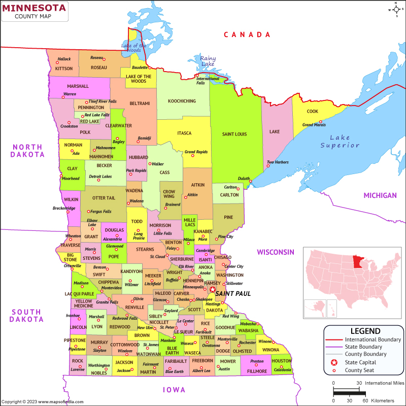
Minnesota is a state situated in the Midwestern portion of the US. It is the 22nd largest state by geographical area and the 21st most populous state with a population of approximately 5.7 million people. The capital city is Saint Paul and the largest metropolitan is Minneapolis.
History
Minnesota was originally inhabited by numerous Native American tribes, including the Dakota and Ojibwe Community. European settlement began in the 17th century, with French fur traders setting up trading posts in the area. Minnesota became a independent territory in 1849 and was admitted to the Union as the 32nd state in 1858. The state played a significant role in the Civil War, providing troops to both the Union and Confederate armies. In the late 19th and early 20th centuries, Minnesota experienced significant growth and prosperity due to its timber, iron, and agricultural industries.
Culture
Minnesota is a very rich state in cultural sense , with significant contributions from its European, Native American, and African American populations. The state is known for its strong Nordic heritage, with many residents tracing their ancestry to Scandinavia. Minnesota is also home to a thriving arts and music scene, with notable musicians including Prince, Bob Dylan, and the Replacements. The state is also known for its love of sports, with professional teams in football, basketball, baseball, and hockey.
Language
The primary language of Minnesota is English, but the state has a significant population of speakers of other languages, particularly Hmong, Spanish, and Somali. The state has a long history of bilingual education and has made efforts to promote multilingualism and cultural diversity in its schools and communities.
Geography
Minnesota is situated in the north central portion of the country and is surrounded by Canada to the northern front, Wisconsin to the eastern front, Iowa to the southern front, and North and South Dakota to the western front. The state is known for its numerous lakes, with over 11,000 throughout the state. The Mississippi River also runs through the state, with its headwaters located in northern Minnesota. The state has a varied climate, with hot summers and cold winters, and experiences severe weather including tornadoes and blizzards.
| Official Name | Minnesota |
| Capital | Saint Paul |
| Area | 225,163 km2 |
| Population | 57.17 Lakh |
| Language | None |
| Religion | Christianity |
| Admitted to the Union | May 11, 1858 |
FAQs
Q1: What is Minnesota known for?
Minnesota is known for its natural beauty, with numerous lakes, forests, and parks throughout the state. The state is also known for its strong Nordic heritage, thriving arts and music scene, and love of sports.
Q2: What is the largest city in Minnesota?
The largest city of the state is Minneapolis, with a population of approximately 425,000 people.
Q3: What is the state bird of Minnesota?
The common loon is the official state bird of Minnesota.
Q4: What is the climate like in Minnesota?
Minnesota has a varied climate, with moderate summers and cold winters. The state experiences severe weather including tornadoes and blizzards.
Last Updated on: August 23, 2023
