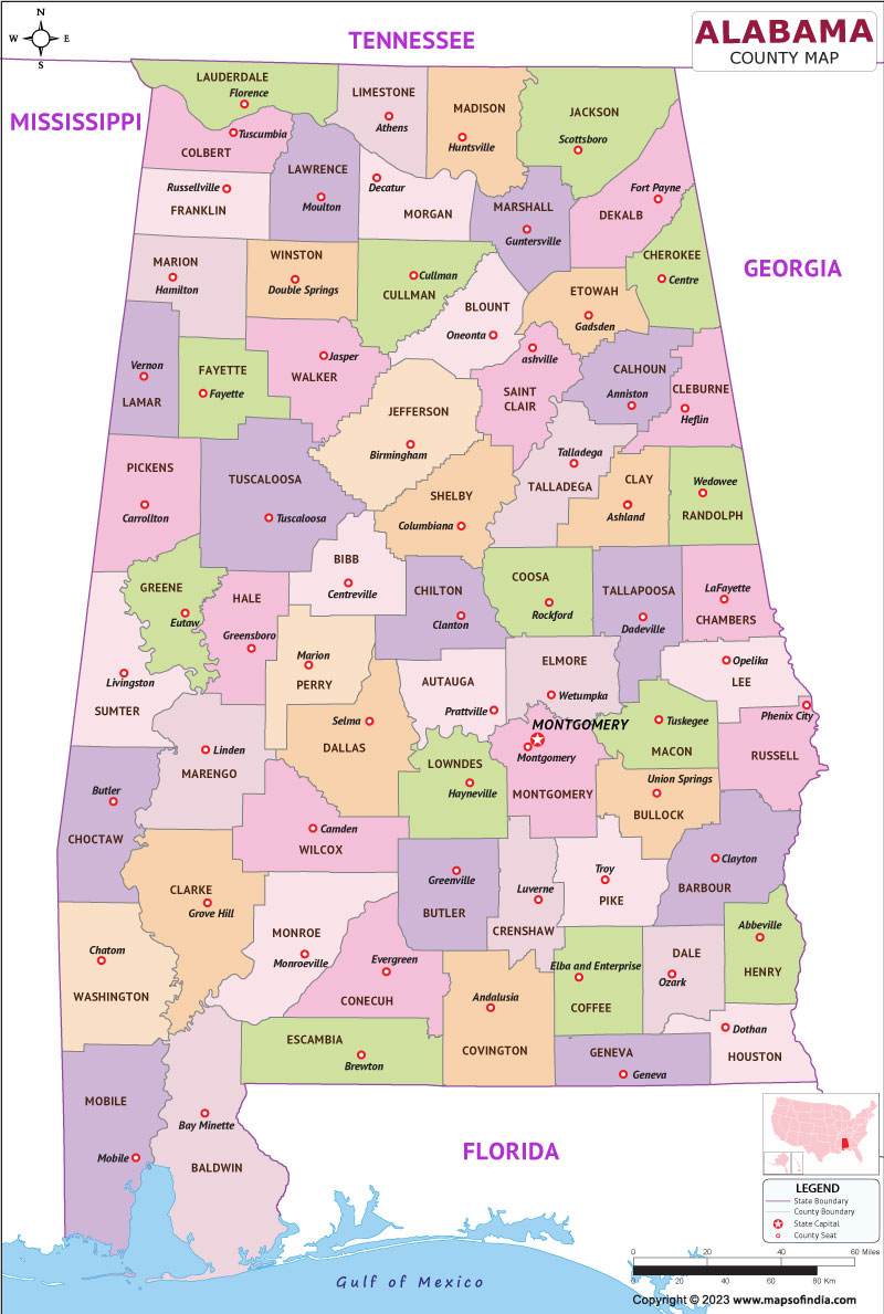
Alabama is a state situated in the southeastern portion of the United States. It is bordered by, Mississippi to the western front, Georgia to the eastern front, Florida to the southern front, and Tennessee to the northern front. The state capital is Montgomery and the largest city is Birmingham.
History
Alabama has a rich and complex history, dating back thousands of years to the indigenous peoples who first inhabited the region. In the 16th century, Spanish explorers arrived in the area, followed by French colonists in the 18th century. The region became a British colony in 1763, and in 1819, Alabama was admitted to the Union as the 22nd state.
Alabama played a significant role in the Civil War, as it was one of the southern states that seceded from the Union. The state was a major center of the Civil Rights Movement in the 1950s and 1960s, with key events such as the Montgomery Bus Boycott and the Selma to Montgomery marches taking place in Alabama.
Culture
Alabama is known for its rich and diverse culture, shaped by its history, geography, and people. The state is home to a variety of cultural institutions, including museums, art galleries, theaters, and music venues. The state has also produced many notable writers, artists, musicians, and athletes, including Harper Lee, Hank Williams, and Jesse Owens.
One of the most distinctive aspects of Alabama culture is its food, which is heavily influenced by Southern cuisine. Popular dishes include fried chicken, barbecue, and seafood, as well as traditional Southern sides such as collard greens, macaroni and cheese, and cornbread.
Language
English is the majority language spoken in Alabama, although the state has a distinct dialect known as Southern American English. This dialect is characterized by features such as a drawled vowel sound, the dropping of the final "g" in words ending in "-ing," and the use of "y'all" as a plural pronoun.
Geography
Alabama is located in the southeastern region of the United States and is bordered by Tennessee to the north, Georgia to the east, Florida to the south, and Mississippi to the west. The state has a diverse geography, including beaches along the Gulf of Mexico, mountains in the northern part of the state, and forests and rivers throughout.
| Official Name | State of Alabama |
| Capital | Montgomery |
| Population | 5,039,877 |
| Area | 135,765 km2 |
| Religion | Christianity |
| Language | English |
| Major Cities | Montgomery, Birmingham |
FAQs
Q1: What is Alabama known for?
The state played a significant role in the Civil Rights Movement and is home to many cultural institutions, such as museums and music venues.
Q2: What are the major industries in Alabama?
The major industries in Alabama include automotive manufacturing, healthcare, defense, aerospace, and agriculture.
Q3: What are some popular tourist destinations in Alabama?
Popular tourist destinations in Alabama include Gulf Shores and Orange Beach, which are known for their beaches and outdoor activities; Birmingham, which has a rich cultural and historical heritage; and Huntsville, which is home to the U.S. Space and Rocket Center.
Q4: What is the weather like in Alabama?
The weather in Alabama varies depending on the season and location within the state.
Last Updated on: June 27, 2023
