
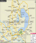
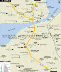
The Jhelum River, a tributary of the Indus River, flows through the city into the Dal Lake. The temperature in the city ranges from 29° C in summer to -2° C in winter. Snowfall in winter cuts road access to the city. Srinagar is connected through the National Highway no 1 A to Punjab and from there to the rest of the country. The NH 1A begins from Jalandhar in Punjab, travels through Srinagar, and further to Uri border in J&K., NH 1D is also known as the Srinagar-Leh road. It joins Srinagar to Kargil and then to Leh in Ladakh.
Srinagar City
Dal Lake in the heart of the city is its major landmark and a top tourist attraction, famous for its house-boats. Srinagar has a number of gardens and tourist spots near the Dal Lake. The gardens are those historically laid down by the Mughal emperors. Some of the tourist spots are
- Mughal Garden
- Shalimar Ghat
- Dargah Sharif is also known as Hazratbal Shrine. It is located on the left bank of the Dal Lake.
- Chashma Shahi Garden, laid by the Mughal emperor Jehangir in the 16th century is a few kilometers from the center of the city.
- Botanical Garden
- Hariparbat Fort
- Nagin Lake is joined to the Dal Lake by a causeway.
- The Lalit Grand Palace is a former palace of the maharaja now converted into a luxury hotel.
- Shankracharya temple is situated on a hill, 1100 feet above the city level. This Shiv temple is the oldest shrine in the city.
The hotels in the city are located near the cantonment in the south, near the Boulevard Road. Some of the hotels are Sadaf, Blooming Dale, Swiss, and the Lalit Grand Palace.
Srinagar also has a number of educational institutes. There are three government schools; the Government Boys Higher secondary School is located in the south of the city near the cantonment, and another one in the north of the city near Batt Bagh. There is a Government girls higher secondary school in the north also. Some of the institutes for higher education are
- University of Agriculture Science & Technology
- Kashmir University
- Polytechnic college
- Islamia college of Science and Commerce
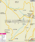
Important Landmarks in The City
- Industrial Estate in the north of the city
- Srinagar Development Authority in the South
- Haji Masjid
- Doona Pora Park
- Hariparbat Fort
- Hussain Park
- Golf Course
Srinagar City Information | |
|---|---|
| Country | India |
| State | Jammu and Kashmir |
| District | Srinagar |
| Established Year | 3rd century BC |
| Founded by | Raja Pranavsarena |
| Area | 294 km2 (114 sq mi) |
| Population | 1273312 as Census January 2011 |
| Population Density | 8,523/km2 (22,070/sq mi) as Census January 2011 |
| Language | Kashmiri, Urdu, Hindi, English |
| Official Languages | Kashmiri, Urdu |
| Literacy Rate | 71.45% as Census January 2011 |
| Sex Ratio | 888 / 1000 |
| Time zone | IST (UTC+5:30) |
| Pin code | 190 001 |
| Area code | 194 |
| Lat Long | 34.0900° N, 74.7900° E |
| Religion | Islam, Hinduism |
| Festivals | Lohri Festival, Navroz Festival, Urs Festival, Baisakhi Festival, Ramzan Festival. |
| University | University of Kashmir, Sher-e-Kashmir University of Agricultural Sciences & Technology of Kashmir |
| Sports | Sher-i-Kashmir Stadium, Bakshi Ghulam Mohammad, Royal Springs Golf Course |
| Airport | Srinagar Airport (IATA code SXR) |
| Railway Station | Srinagar railway station |
| Tourist Attractions | Dal Lake, Chashma Shahi ,Nishat Bagh ,Shalimar Bagh ,Sher Garhi Palace ,Gulab Bhavan |
| Nearby Tourist Attractions | Gulmarg, Pahalgam ,Sonamarg |
| Popular Things | Carpets, shawls, handcrafted clothes, Dry fruits and spices, furniture and showpieces made in Srinagar, Royal Springs Golf Course,Pari Mahal, Tulip Garden. |
| Notable People | Khwaja Abdul Karim Kashmiri, Lalla Arifa, Bulbul Shah, Sheikh Hamza Makhdum, Gulam Ahmad Mehjoor |
| National Highway | National Highway 1A, National Highway 1D |
Last Updated on : May 08, 2026
Travel to Jammu and Kashmir
Places to Visit Jammu and Kashmir
| Find Distance from Srinagar to other Indian Cities | |||