


Jharkhand, a Goldmine of Mineral Resources
Introduction
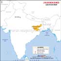
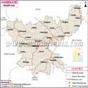
Jharkhand lies in eastern India, formed on November 15, 2000. It shares its borders with Bihar to the north, Uttar Pradesh to the northwest, Chhattisgarh to the west, Odisha to the south, and West Bengal to the east. It became an independent state after splitting from Bihar. Ranchi is the capital of Jharkhand, which is a well-known industrial and academic city of Jharkhand.
Geography
Jharkhand is known as a mining and industrial hub of India with Jamshedpur, Bokaro, and Dhanbad as the highly industrialized cities of eastern India. It is replete with thick forest, mines, and natural beauty. That is why it is well-known as one of the wealthiest states of the country with a skilled workforce, abandoned mineral wealth, and forestry products.
Its cover of thick forests is the natural habitat of tigers and Indian elephants. Jharkhand is the origin of various rivers such as Koel, Damodar, Brahmani, Subarnarekha, and others. Known for its rich flora and fauna, it is home to various national parks and the zoological gardens: Betla National Park, Hazaribagh Wildlife Sanctuary, Udhwa Lake Bird Sanctuary, and Singhbhum Elephant Reserve, Palamu Tiger Reserve.
Demographics
Jharkhand's population is 32,988,134, as per the 2011 census, consisting of 16.93 million males and 16.03 million females. The sex ratio of the state is 947 females to 1,000 males (as per the 2011 census). It occupies the 14th position regarding total occupiers in the country.
About one-third of its population is tribal. There are as many as 32 tribes in Jharkhand, out of these nine are classified as PTG (Primitive Tribe Groups). They are – Asur, Birhor, Birajia, Korwa, Parahiya (Baiga), Sabar, Mal Pahariya, Souriya Pahariya, and Bile Kahria.
Jharkhand has seen a lot of migration from the neighbouring states of West Bengal and Bihar for employment. In this state, tribal communities do not follow Hinduism; they have their own spiritual beliefs called Sarna.
Mineral Wealth
As discussed earlier, Jharkhand is the goldmine of minerals and ores such as iron ore, copper ore, mica, coal, bauxite, manganese, fireclay, china clay, limestone, kainite, graphite, chromites, uranium, thorium, asbestos, gold, silver, and Yemenite. In the production of some of these minerals and ores, Jharkhand ranks among the top three states of India.
Politics
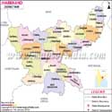
Despite its industrial growth and mineral resources, the people are financially poor, and the civic infrastructure and amenities in the state are substandard. The poor situation in Jharkhand arises due to poor governance and corruption in politics. Annual per capita income is also low. Jharkhand has 24 districts, and the Jharkhand government runs the government machinery, which is assisted by a lobby of IAS officers.
Religions and Language
After sweeping colonization, followers of other religions such as Hinduism, Islam, and Christianity also settled here, but tribal faith Sarna is still growing. Bhojpuri, Hindi, Bengali, and Urdu are the main languages spoken, whereas the tribal people also speak their language: Kharia, Paharia, Bhumij, Mundari, Santhali, and Ho. People of Jharkhand utter some of the Dravidian languages like Oraon and Korwa in the state as well.
Jharkhand State Information | |
|---|---|
| Capital | Ranchi |
| Date of formation | 15. Nov. 2000 |
| Governor | Shri Santosh Kumar Gangwar |
| Chief Minister | Hemant Soren |
| Tourist attractions | Dassam Falls, Sun Temple, Birsa Zoological Park, Jamshedpur Industrial Area |
| Festivals | Basant Panchami, Chhat Puja, Sarhul, and others |
| Major dance and music forms | Agni and Jhumar dances |
| Arts and crafts | Large colourful masks made from the dark clay taken from the banks of the River Khakai; Jadu Patua is a form of scroll painting. |
| Languages | Hindi, Urdu, Santhali |
| Size | 79,714 km2 (30,778 sq mi) |
| Population (Census 2011) | 32988134 |
| Rivers | Damodar, Subernarekha, Kharkal and so on |
| Forests and wildlife sanctuaries | Betla (Palmau) NP, Hazaribagh Wildlife Sanctuary |
| State animal | Elephant |
| State bird | Asian koel |
| State flower | Palash |
| State tree | Sal |
| Major crops | Paddy, wheat, maize |
| Factoids | Dhanbad is also known as India's coal capital. |
| Jharkhand's original inhabitants, the adivasis, revolted against British exploitation of their forests. | |
| No. of District | 24 |
Maps in Other Regional Languages
Last Updated on: May 11, 2026