After the reorganisation of the state of Jammu & Kashmir in 2019, it was made into two union territories, namely; Jammu & Kashmir and Ladakh. Leh, which is a popular tourist destination in India was made the joint capital of the union territory of Ladakh along with Kargil. Lying between the Kunlun mountain range in the north and the main Great Himalayas to the south, this region is among the most sparsely populated regions in the state. It is located at an elevation of 3505 meters (11,550 feet) from sea level.
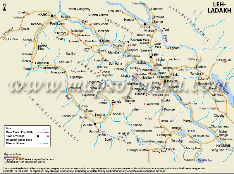
After being cut down from the rest of India for a long haul in its history, Leh has become a popular tourist destination among both domestic and international tourists. If someone is looking forward to gaining more knowledge about this region, then they can start with a well-demonstrated map of Leh-Ladakh. The above-given map can help you to know about the areas that lie in Leh and Ladakh.
Lying on the bank of the Indus river and Snuggled in the Himalayas, Leh presents unique topographical features. It has Snow-capped silvery mountain peaks and golden barley farmlands that run together presenting a great view. It is shown on the map that the area is watered by the Zanskar River that flows into the Indus River just below.
A popular tourist attraction and a structure of historical importance in the entire city of Leh is the Leh Palace. It is a Tibetan-styled palace which served as the royal residence of the Royal family of Ladakh. Moreover, the city runs north narrowing into eroded snow-capped peaks. Rock and snow - cover most of its geology. A city with amazing geological and ecological features attracts thousands of adventure-loving travellers from across the world.
Climate
Leh experiences a harsh cold desert climate due to its geographical location. It witnesses extreme winter during the months from November to March. The minimum temperature reaches about -40 degrees. On the contrary, summers are quite warm with temperatures around 30 degrees, and clear skies. The weather in Leh is usually arid and is under the rain-shadow area of the Himalayas.
This city is fondly known as the "rooftop of the world". Besides, Leh is known for its climatic extremities. It is because this is the only place in the world, which can give you sunburn and frostbite simultaneously.
Historic value
In early times, Leh served as an important trade route for trade of silk yarn, Cashmere wool, Brocade, Resins and Semi-precious stones. It fell at the crossroads of old routes from Kashmir, Tibet and China. During the times of Dard colonisers, Leh used to be an important stopover for Tibetan nomads and traders.
It sees a high influence of Buddhist Monks as one can find Buddhist monasteries of the 2nd century, monuments, and stupas. It also has Mughlai mosques belonging to the 16th century which shows the mixed cultures of the two faiths.
Technology in Leh
Despite being situated at a higher altitude making Leh not that easily approachable, it has access to all the latest technology and modern facilities. It is the home to the world’s highest VSAT centre. Continuous efforts are made by the district administration to develop a technology society.
Travel agencies, Hospitals, Internet cafes, Post Office, Bookstores, Curio shop and Gift shops, everything is available for tourists. In addition, it also has restaurants that serve a variety of cuisines allowing the travellers to relish the food of their choice.
If you are planning a trip to this interesting land, you must check this well-defined Leh Ladakh map.
Last Updated on: May 08, 2026