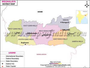
 In the northeast part of India lies Meghalaya - "the Abode of Clouds". It is a beautiful mountainous state in the eastern sub-Himalayan region.
The districts of Meghalaya are home for many tribal people of our country. It's the native soil of the Khasi, Jaintias and Garo tribes. The western region is inhabited by Garo tribe, the Jaintias tribe in the eastern region and the central region by Khasi tribe.
In the northeast part of India lies Meghalaya - "the Abode of Clouds". It is a beautiful mountainous state in the eastern sub-Himalayan region.
The districts of Meghalaya are home for many tribal people of our country. It's the native soil of the Khasi, Jaintias and Garo tribes. The western region is inhabited by Garo tribe, the Jaintias tribe in the eastern region and the central region by Khasi tribe.
Meghalaya has a total number of Seven Districts. Each district is further divided into sub-divisions and blocks. The Deputy Commissioner is the head of each district.
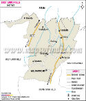
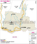
East Garo Hills district - (Area - 2603 km2, Population - 317,618) Its headquarters is Williamnagar. It is divided in 5 administrative division blocks. It houses the Nokrek National Park.
East Khasi Hills district - (Area - 2752 km2, Population - 824,059) Its headquarters is Shillong and is the most populated district. It is divided in 8 administrative division blocks.
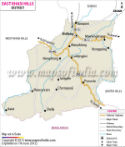
Jaintia Hills district - (Area - 3819 km2, Population - 392,852) Its headquarters is Jowai and the district possesses charming natural beauty. It is divided in 5 administrative division blocks.
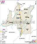
Ri-Bhoi district - (Area - 2378 km2, Population - 258,380) Its headquarters is Nongpoh. It is divided in 3 administrative division blocks and is the second least populated district.
South Garo Hills district - (Area - 1850 km2, Population - 142,574) Its headquarters is Baghmara It is divided in 4 administrative division blocks and is the least populated district.
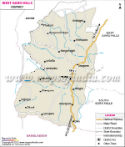
West Garo Hills district - (Area - 3714 km2, Population - 642,923) Its headquarters is Tura. It is divided in 8 administrative division blocks and is the second most populated district.
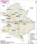
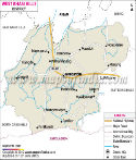
West Khasi Hills district - (Area - 5247 km2, Population - 385,601) Its headquarters is Nongstoin. . It is divided in 6 administrative division blocks and houses the Langshiang Falls, the third highest falls in India.
List of Districts in Meghalaya
| Sr. No. | District | District HQ | Population (2011) | Growth | Sex Ratio | Literacy | Area (km2) | Density (/km2) |
|---|---|---|---|---|---|---|---|---|
| 1 | East Garo Hills | Williamnagar | 317917 | 0.2687 | 972 | 73.95 | 2603 | 121 |
| 2 | West Garo Hills | Tura | 643291 | 0.2409 | 984 | 67.58 | 3714 | 173 |
| 3 | North Garo Hills | Resubelpara | * | * | * | * | * | * |
| 4 | South Garo Hills | Baghmara | 142334 | 0.4095 | 945 | 71.72 | 1850 | 77 |
| 5 | South West Garo Hills | Ampati | * | * | * | * | * | * |
| 6 | East Jaintia Hills | Khliehriat | * | * | * | * | * | * |
| 7 | West Jaintia Hills | Jowai | 395124 | 0.321 | 1013 | 61.64 | 3819 | 103 |
| 8 | East Khasi Hills | Shillong | 825922 | 0.2496 | 1011 | 84.15 | 2752 | 292 |
| 9 | South West Khasi Hills | Mawkyrwat | * | * | * | * | * | * |
| 10 | West Khasi Hills | Nongstoin | 383461 | 0.2953 | 980 | 77.87 | 5247 | 73 |
| 11 | Ri-Bhoi | Nongpoh | 258840 | 0.3426 | 953 | 75.67 | 2378 | 109 |
Last Updated on : June 24, 2026