


History of Himachal Pradesh
The history of Himachal Pradesh is an old one, inhabited by tribes such as Dagis, Khasas, Koilis, Halis, Dhaugris, Dasa, Kinnars, and Kirats. Around 883 AD, some parts of the state were under the control of the king of Kashmir, Sankar Varma. Around 1009 AD, Mahmud of Ghazni invaded the region. Rajputs exercised influence over the area around 1043. During the time of the Mughals Empire, many kingdoms in the region accepted the authority of the Mughals.
By 1804, vast regions of the state passed into the hands of Sikh emperor Maharaja Ranjit Singh. Gorkha had also ruled many areas of Himachal Pradesh. The region finally passed into the hands of the British, who ruled here till 1947, when it became a part of independent India. In the year 1 November 1956, Himachal Pradesh became a Union Territory of India. However, it got the state status on 25 January 1971. Himachal Pradesh emerged as the eighteenth state of India. The word 'Hima' actually means snow in Sanskrit terminology. Acharya Diwakar Datt Sharma, an eminent Sanskrit Scholar from Himachal Pradesh, named the state.
Economy of Himachal Pradesh
The state boasts of numerous picturesque tourist destinations. Tourism is an important industry and is a vital contributor to the state's economy. Agriculture is also one of the most significant contributors, which is over 45% of the net state domestic product. Textiles and the burgeoning hydroelectric power export industry are the other sources of income for the state.
The state is capable of generating plenty of hydroelectricity power. Therefore it sells its buffer to Punjab, Delhi, and Rajasthan. Himachal Pradesh is one of the fastest-growing states in India. At current prices, the Gross State Domestic Product of Himachal Pradesh reached Rs 1.82 trillion (US$ 26.04 billion) in 2020-21. The per capita GSDP of Himachal Pradesh in 2019-20 was Rs 225,839 (US$ 3,203.85).
Geography
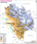
Himachal Pradesh lies in the western Himalayas, and most of its part has been lying in the foothills of the Dhauladhar Range. Reo Purgyil, with a height of 6,816, is the highest mountain peak. Some of the drainage river systems located in the state are Chenab, Beas, Ravi, Yamuna, and the Sutlej.
The forest cover in Himachal Pradesh in 2019 jumped by 333.52 sq km in the comparison to the previous assessment recorded in 2017, as per the date of the Indian State of Forest Report-2019 The recorded forest area (RFA) in the state is 37,033 sq km, out of which 1,898 sq km is reserved forests, 33,130 sq km is protected forests and 2,005 sq km is unclassed forests. The protected area has five national parks, 28 wildlife sanctuaries, and three conservation reserves. It covers around 15.10% of the geographical land of the state.
Himachal Pradesh boasts of a wide variety of fauna, which includes more than 463 birds, 80 fish, 77 mammalian, and some 44 reptile species.
Administration in Himachal Pradesh
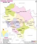
Himachal Pradesh has 12 districts. The Deputy Commissioner, also known as District Magistrate, keeps eyes on works in all the district headquarters. Then come to the smaller unit known as sub-divisions, controlled by the sub-divisional magistrates. The Superintendent of Police maintains the law and order situation.
Himachal Pradesh has 12 districts, which are listed below:
Several pilgrimage centers and Hindu temples are lying in Himachal Pradesh. There are more than two thousand temples in Himachal Pradesh. The beauty and the architecture of the temples are magnificent and worth seeing, which is the main attraction for tourists and visitors. Many of them are also associated with ancient legends.
|
|
Himachal Pradesh at a Glance |
| Area | 55,673 km2 | Population (Census 2011) | 6864602 |
| Females | 3,382,729 | Males | 3,481,873 |
| Urban Population | 6,88,552 (2011 Census) | Rural Population | 61,76,050 (2011 Census) |
| Population Density | 123/km2 (320/sq mi) | Sex Ratio | 974 |
| Literacy Rate | 82.80% (2011 Census) | Female Literacy | 75.93% (2011 Census) |
| Male Literacy | 89.53% (2011 Census) | Districts | 12 |
| Sub Division | 69 | Tehsils | 169 |
| Sub Tehsils | 169 | Towns | 59 |
| Developmental Block | 78 | Panchayats | 3517 |
| Panchayat Smities | 78 | Zila Parishad | 12 |
| Nagar Nigam | 2 | Nagar Parishad | 20 |
| Nagar Panchayats | 33 | Urban Local Bodies | 53 |
| Census Villages | 20,690 | Inhabited Villages | 2868 |
| Educational Institutions | 17000 | Health Institutions | 3835 |
| Motorable Roads | 4587 km | National Highways | 9 |
Himachal Pradesh State Information | |
|---|---|
| Capital | Shimla |
| Date of formation | 25/01/71 |
| Governor | Shiv Pratap Shukla |
| Chief Minister | Sukhvinder Singh Sukhu |
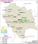
| Tourist attractions | Shimla, Kulu, Manali, Dharamsala |
| Festivals | Pori, Fulaich |
| Major dance and music forms | Mala dance, Rakshas Dance |
| Arts and crafts. | Pahari painting is done in the Basohli and Kangra styles; Kullu shawls and woollen caps are famous; the Chamba Rumal has Kangra style paintings embroidered on cloth. |
| Languages | Hindi, Punjabi, Kinnauri, Pahari |
| Size | 55,673 km2 (21,495 sq mi) |
| Population | 6864602 |
| Rivers | Ravi, Beas, Chenab, Sutlej, Yamuna |
| Forests and wildlife sanctuaries | Pin Valley NP, Greater Himalayan NP, Renuka WS, Chail WS, Kalatope Khajjiar WS |
| State animal | Snow leopard |
| State bird | Western tragopan |
| State flower | Pink rhododendron |
| State tree | Deodar |
| Major crops | Wheat, rice, maize, barley |
| Factoids | The world's oldest democracy is believed to be a tiny, isolated village called Malana. |
| Shimla was the summer capital of british India. | |
| No. of District | 12 |
Maps in Other Regional Languages
Last Updated on: January 14, 2026