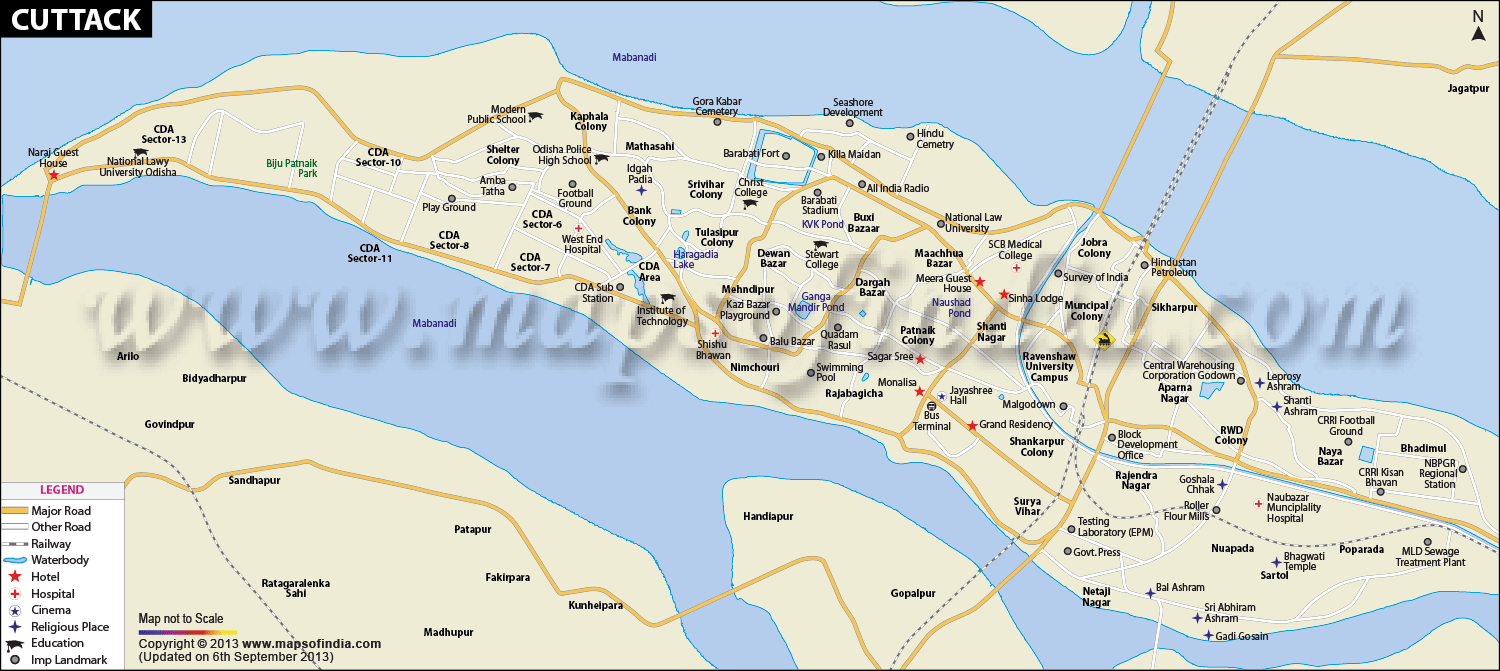
Cuttack City Map
Cuttack is the former capital city of
Odisha and the current headquarters of the Cuttack district. Spread across an area of 298 sq km, the city of Cuttack is situated at the apex of the Mahanadi River Delta and is located about 28 km north of Bhubaneswar, the capital of Orissa.
The city is enclosed by the Mahanadi River and its tributaries, the Kathjori, the Kuakhai and the Birupa from nearly all the sides. The city has an average elevation of 36 metres and the city's coordinates are 20.5°N 85.83°E.
The city of Cuttack has a tropical wet and dry climate. The summers remain hot and humid. The monsoon months are when the city receives most of its rainfall. The winters are noted by mild temperatures and occasional showers. Temperatures may go beyond 40°C in summers and may fall below 10°C in winters. As the city lies close to the eastern coast, it is prone to storms from the Bay of Bengal. Thunderstorms in summer also cause damages. The Mahanadi River and various ponds in the city which store rain water, provide much of the drinking water in the city.
The city has a population of 606,007 individuals as of the 2011 India census with Males comprising 52% and females comprising 48% of the population. The city has an average literacy rate of 77% and the official language spoken here is Oriya. About 94% of the city's population is Hindu, 5 % Muslims while others religions comprise of 1%. At the state Assembly level the city of Cuttack is divided in three constituencies viz. Barabati-Cuttack, Choudwar-Cuttack and Cuttack Sadar.
The transportation facilities in the city are good. The National Highway 5 passes through the city and connects to major cities like Kolkata and Chennai.
td>
Ward59 |
| Lat Long | 20.459408, 85.883195 |
| Area | 192.5 Sq.Km. |
| Population as per 2011 | 6,10,189 |
| Official Languages | Oriya, English |
| Time zone | IST (UTC+5:30) |
| STD Code | 0671 |
| Transport | Air, Road, Rail |
| Vehicle registration | OR-05/OD-05 |
| Food and Cuisine | Vegetarian and Non-Vegetarian Delicacies, Rice, Bhindi Bhaja, Kadali Bhaja, Aalu Palak, Jeera Pakhala and Saag, Prawn Malai Curry, Crab Kalia, Chilli Fish and Fish Curry Mughlai, Chinese, Indian Cuisines, Oriya Cuisine etc. |
| Religion | Hindu, Muslim, Other |
| Festival | Dusshera, Kali puja, Bali Yatra, Kartikeshwar Puja, Kite Flying Ganesh Chaturthi, Vasant Panchami, Holi, Id, Good Friday, Rath Yatra, Diwali, Christmas and the Numerous Hindu festivals are celebrated here . |
| Monuments | Barabati Fort, Salipur Branch Museum, The Stone Revetments of Cuttack, Katak Chandi Temple, Paramahansa Nath Temple, Jama Masjid etc. |
| Places of interest | Barabati Fort, Dhabaleswara Cuttack, Jawaharlal Nehru Indoor Stadium, Mahanadi River, Kathajodi River, Goddess Mangala, Chaudhury Bazar Chandi Medha, Dolomundai, Lord Kartikeya, Cow horn sculpture, Jobra Barrage, Night view of Cuttack Railway Station. |
| Hotels | Bombay Inn Hotel, Triple C, Hotel Neeladri, Hotel Sheetal, Hotel Sagarshree, Promod Resorts, Lord`s Travels, Bishal inn, Roxy Hotel, Madras South Indian Hotel etc. |
| Markets | Arunodaya Market Complex at Link Road, Jajati Kendra Market Complex at Buxi Bazaar, Dinabandhu Bipani at Buxi Bazaar ,Peripheri Market Complex at Buxi Bazaar, Banijyalaya Market Complex at Bajkabati Road, Mahanadivihar Market Complex at Sikharpur, Paribahan Market Complex at Jagatpur, Chicken Market at Buxibazar, Subham Market Complex, Santasahi Canal Market, Kalyani Market Complex, Haripur Local Market, Sai Market Complex, Sameer Market Complex, Badambadi Stand Market Complex, Fish & meat market at Sector-6, Bidanasi, 360, Sector-6 etc. |
| Industries | Business Houses, Ferrous Alloys, Steel and Logistics to Agriculture and Traditional industries like Textiles and Handicrafts, Silver Filigree Works, Leather Work, Silver and Cotton Textile Mills, Trade and Transport, Agriculture - Crops, Vegetables Fruits, Rice, Jagatpur and Khapuria are Industrial estates inside the city and Oriya Film Industry. |
| University | Ravenshaw University, National Law University, Sri Sri University, Sri Ram Chandra Bhanja, S.C.B. Medical College, Jatia Kabi Bira Kishore (J.K.B.K.) College, Sailabala Women's College, Stewart Science college, Christ College, Sri Aurobindo Institute of Higher Studies & Research, Textile Engineering College, Dhaneshwar Rath Institute of Engineering & Management Studies (DRIEMS), Image Institute of Technology & Management (IITM), Ajay Binay Institute of Technology (ABIT), Central Rice Research Institute, Acharya Harihar Regional Cancer Centre (AHRCC) etc. |
| Notable people | Utkal Gourab Madhusudan Das - Lawyer, Social reformer, Minister, Industrialist, Subhas Chandra Bose, Biju Patnaik - Indian Politician and Chief Minister of Odisha, Giridharilal Kedia - Former Working President of KVK, Cuttack; Past District Governor of Lions Club International 322C & Former Chairman of IITM Cuttack, Sona Mohapatra - Indian Singer, Music Somposer and lyricist etc |
Last Updated on : May 11, 2026