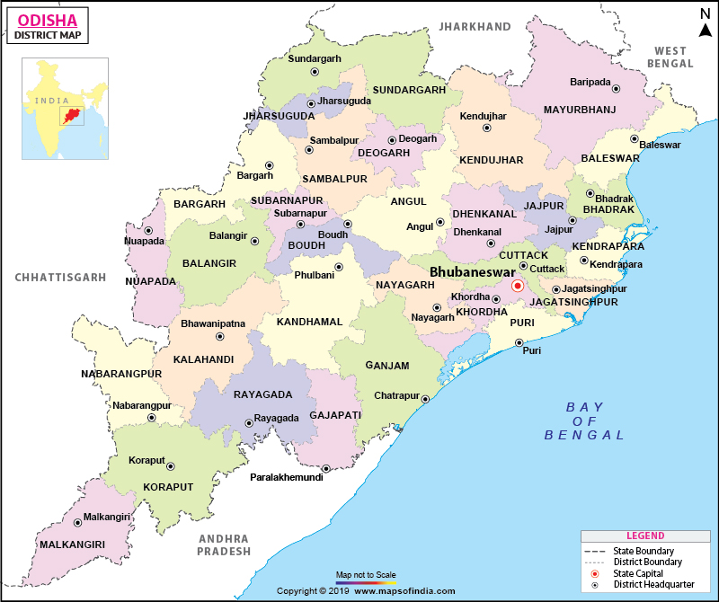
Extending from the evergreen Eastern Ghats to the bio-diverse coastal plains, Odisha (formerly known as Orissa/ Kalinga in 261 BC) is renowned for its rich cultural heritage, glorious coastline, wonderful nature reserves, classical dance forms, and historical monuments.
Odisha is located on the eastern coast of India, bounded by the Bay of Bengal, sharing its western border with Madhya Pradesh and Andhra Pradesh on the South. The region was under the rule of Emperor Ashoka of the Maurya dynasty in 261 BC and known as the kingdom of Kalinga. The modern state of Odisha comprises of an area of 155,707 square kilometres, Odisha has a population of approximately 4.2 crores as per2011 census. The population density is 269 per sq km while the literacy rate is 73 percent.
Nearly three quarters of the area is replete with mountains and rivers (Subarnarekha, Budhabalanga, Indirabati, Kolab,, Nagabali, Bansadhara, Bahuda, Baitarani, Brahmani, Mahandi, Salandi, and Rushikulya) make their way into the Bay of Bengal through Odisha. The state capital Bhubaneswar is known as the "Temple City of India".
Districts and Administration of Odisha
The state has 30 Districts and each district is governed by a District Magistrate who is appointed by the Odisha Administrative Services or the Indian Administrative Services. Each district is split into sub divisions. These sub divisions are further divided into blocks and blocks into town municipalities and village panchayats. As per 2011 census, Mayurbhanj is the largest district in Odisha while Ganjam is the most populous district.
Tourism in Odisha
Though Odisha lacks iconic tourist attractions like in North India, the state is gaining popularity as an offbeat travel destination. The state has very diverse topography, right from the Eastern Ghats to a fertile river basin, which is a suitable habitat for native flora and fauna. Mountain springs and hot-springs abound in Odisha and most of the rivers have waterfalls - either at the point of origin or over the mountainous bed. The Chillika, a salt water lake is spread over three districts; Puri, Khurda and Ganjam. The Ansupa, a sweet water lake lies in Cuttak district.
The state is noted principally for religious attractions such as the Lingaraja Temple in Bhubaneswar, the Jagannath Temple in Puri and the Sun Temple in Konark. Other famous tourist attractions in Odisha are: Puri beach, Chillika Lake, Bhitarkanika Sanctuary, Simlipal National Park, and Udayagiri and Khandagiri Caves.
List of Districts in Orissa
| S No. | District | Headquarters | Population (Census 2011) | Sex Ratio (per 1000) | Average Literacy |
|---|---|---|---|---|---|
| 1 | Angul | Angul | 1273821 | 943 | 77.53% |
| 2 | Balangir | Balangir | 1648997 | 987 | 64.72% |
| 3 | Baleshwar | Balasore | 2320529 | 957 | 79.79% |
| 4 | Bargarh | Bargarh | 1481255 | 977 | 74.62% |
| 5 | Bhadrak | Bhadrak | 1506337 | 981 | 82.78% |
| 6 | Boudh | Boudh | 441162 | 991 | 71.61% |
| 7 | Cuttack | Cuttack | 2624470 | 940 | 85.50% |
| 8 | Debagarh | Debagarh | 312520 | 975 | 72.57% |
| 9 | Dhenkanal | Dhenkanal | 1192811 | 947 | 78.76% |
| 10 | Gajapati | Paralakhemundi | 577817 | 1043 | 53.49% |
| 11 | Ganjam | Chhatrapur | 3529031 | 983 | 71.09% |
| 12 | Jagatsinghpur | Jagatsinghpur | 1136971 | 968 | 86.59% |
| 13 | Jajpur | Panikoili | 1827192 | 973 | 80.13% |
| 14 | Jharsuguda | Jharsuguda | 579505 | 953 | 78.86% |
| 15 | Kalahandi | Bhawanipatna | 1576869 | 1003 | 59.22% |
| 16 | Kandhamal | Phulbani | 733110 | 1037 | 64.13% |
| 17 | Kendrapara | Kendrapara | 1440361 | 1007 | 85.15% |
| 18 | Kendujhar | Kendujhar | 1801733 | 988 | 68.24% |
| 19 | Khordha | Khordha | 2251673 | 929 | 86.88% |
| 20 | Koraput | Koraput | 1379647 | 1032 | 49.21% |
| 21 | Malkangiri | Malkangiri | 613192 | 1020 | 48.54% |
| 22 | Mayurbhanj | Baripada | 2519738 | 1006 | 63.17% |
| 23 | Nabarangapur | Nabarangpur | 1220946 | 1019 | 46.43% |
| 24 | Nayagarh | Nayagarh | 962789 | 915 | 80.42% |
| 25 | Nuapada | Nuapada | 610382 | 1021 | 57.35% |
| 26 | Puri | Puri | 1698730 | 963 | 84.67% |
| 27 | Rayagada | Rayagada | 967911 | 1051 | 49.76% |
| 28 | Sambalpur | Sambalpur | 1041099 | 976 | 76.22% |
| 29 | Subarnapur | Subarnapur | 610183 | 960 | 74.42% |
| 30 | Sundergarh | Sundergarh | 2093437 | 973 | 73.34% |
Maps in Other Regional Languages
Last Updated on: February 19, 2026
