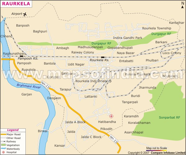
Rourkela has a hilly and undulating topography .The city was once surrounded by forests and today there are two reserved forests around the area of the city. The Durgapur forest lies in the north of the town and the Sonparbat reserve forest lies in the south. The Brahmani River flows in the west of the city. This seasonal river is formed by the confluence of two small tributaries the Koel and the Sankh and flows at the periphery of Rourkela city.
Parts of the Rourkela city developed after the setting up of the Rourkela steel plant here. The old Rourkela area or Purana Rourkela including Entabatti and Phulbari is the older part of the city .The new parts of the city are Pamposh, Rourkela Township, and Ambagh. The inhabited urban areas are Udit Nagar, Pamposh, Aam Bagh, Railway Colony, and the Industrial Estate or strip. South Rourkela is predominantly rural in areas such as Jalda , Lathikanta, Pikodih, Tangarpali, Tarapur. The population in the surrounding areas is mostly tribal.
Road and Railway Connection
Rourkela is connected through the National highway no 23 which passes through the city. The NH 23 connects Jharkhand, passing through Rourkela, to Talcher in Odisha, at the junction of NH 42.
As Rourkela is an industrial city, it has a very well developed rail connection to major cities in the country, such as Ahmedabad, Bengaluru, Bhubaneshwar, Chennai, Jamshedpur, Nagpur etc. The city is on the South Eastern railway line which connects Kolkata and Mumbai. The railline passes through the heart of the city and has two major railway stations. These are the Rourkela Railway junction and the Pamposh Railway station. The area around the rail line has the urban townships.
The Rourkela Airport is in the west of the city. The airstrip was built in the sixties. The Airport offers limited flights to some cities and is not open for public.
