
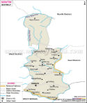
South Sikkim comprises of a population of 1,31,506, and 68,227 male and 63,279 female.
The local people of South Sikkim practice "Terrace Plantation". Most of the people of this district depend on the tourism industry to earn their living.
South Sikkim is blessed with many tourist spots, chief among which is the Namchi, Meanam wildlife Sanctuary, Tea gardens and many other places equally appealing to the tourists.
Important Places in South District
Riyot, Maidong, Brang Polot, Lingi, Lingmo, Mangjing, Rabang, Aitbare, Sosing, Rabongia, Sangmo, Yangang, Ben, Reyong, Maidong, Damthang, Maidong, Ranguthang, Parbing, Jorthang, Namthang, Chidam, Manjhitar, Sumbuk, Melli Bazar
Last Updated on : April 17, 2026