

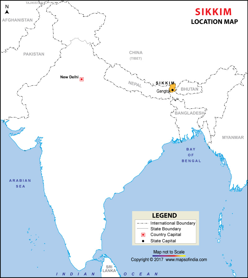



Where is Sikkim Located?
Sikkim is located in the eastern Himalayas and is the smallest state in India in terms of area. It lies approximately between 27°04'46" N and 28°07'48" N latitudes and 88°00'58" E and 88°55'25" E longitudes. The area of the State is approximately 7096 square kilometres.
The State is located in a key position in the Himalayan region. It is surrounded by the Tibet Autonomous Region of China in the North and North-east, Bhutan in the East and South-east, Nepal in the West and south-west, and West Bengal in the South. Hence, Sikkim has Tri-junctional borders on its three sides and is linked with mainland India through West Bengal.
The geographical location map of Sikkim is helpful to understand the boundaries and Sikkim's position in the context of India. It also guides the user to recognise Sikkim as a landlocked state in the Himalayas and its being surrounded by high mountain ranges and valleys.
Sikkim and Its Neighbouring Regions
Sikkim has a unique international/National boundary pattern due to its geographical location.
- North and Northeast: Sikkim shares its boundary with the Tibet Autonomous Region of China.
- East and Southeast: Bhutan lies along Sikkim's eastern and southeastern boundary.
- West: Nepal borders Sikkim along its western side.
- South: West Bengal is the only Indian state that shares a direct boundary with Sikkim.
Sikkim’s Terrain and Mountain Landscape
The mountain ranges are rough, deep valleys, glaciers, forests, rivers and high-altitude lakes are present in Sikkim. Geographical relief in the State is very great over a small area, with resulting variations in climate and vegetation. The Government of Sikkim states that it has a subtropical environment in the lower region, a temperate environment in the middle region and an alpine environment in the upper region.
Major Himalayan ranges bordering and traversing the state contribute a lot to the geographical features of the state. To the west, Sikkim is bordered by the Singalila Range, to the east by the Chola Range, which is part of the Eastern Border region. To the north, the landscape is dominated by the Greater Himalayan ranges. Historically, Sikkim has been linked with Tibet through important passes in the mountains such as Nathu La and Jelep La.
Khangchendzonga, also known as Kangchenjunga, is one of the most prominent geographical features of Sikkim. It is the highest peak in India and the third-highest peak in the world at an altitude of about 8,586 metres. Sikkim's natural and cultural values are symbolized and defined by the mountain and its high-lying terrain.
Rivers and Drainage
The drainage system of Sikkim is greatly influenced by the locality and mountainous topography. Teesta and Rangeet are the main rivers of the state. The origin of Teesta is in the high-altitude northern part of Sikkim and flows in a south-to-south-east direction through the state and joins West Bengal. The Rangeet also drains a significant portion of Sikkim and connects with the Teesta at Melli.
It has a large drainage network of mountains in Sikkim, including several streams, glaciers and lakes. It is located in the high-altitude region of the state, and famous lakes include Gurudongmar Lake, Tsomgo Lake and Khecheopalri Lake. These water bodies play a key geographical role, as well as being a key attraction for visitors.
Districts and Administrative Location
The state of Sikkim is at present divided into six Districts – Gangtok, Mangan, Namchi, Pakyong, Soreng and Gyalshing. The state capital, as well as an important administrative, commercial and tourist centre, is Gangtok. The official map of the state shows the six districts and their administrative centres, and gives a detailed picture of the internal geography of Sikkim.
The districts are spread throughout the mountain state. The northern portion is in Mangan, the west in Gyalshing and the south-west in Soreng. Gangtok and Pakyong are in the central and eastern parts of the area, and Namchi in the southern part. The distribution of their sites corresponds to the diversity of the land and population of the state.
Importance of Sikkim's Location
The geographical, environmental, cultural and strategic significance of the location of Sikkim cannot be denied. Being situated between Nepal, Bhutan and Tibet as well as West Bengal, it comes at the crossroads of several regions of the Himalayas. The state is also adjacent to the Siliguri Corridor, a vital land link between mainland India and the North-East states.
Sikkim is also blessed with a rich diversity due to its Himalayan environment. It is found on a variety of landscapes, from lowlands in the tropics to higher altitudes in alpine areas. This diversity provides a wide variety of flora and fauna, and the state is a significant ecological region of the eastern Himalayas.
Besides its location, Sikkim is also important for tourists. It is a popular mountain destination, with renowned monasteries, lakes, glaciers, valleys and high passes in the country, welcoming visitors from all over India and around the globe. Gangtok is a major gateway to visit the eastern and central part of the state, while other places like Pelling, Namchi, Lachung, Lachen and Yuksom offer access to various parts of the mountainous terrain of the state.
Sikkim Location Map: Key Facts | |
|---|---|
| Feature | Details |
| Location | Northeastern India, Eastern Himalayas |
| Area | 7,096 sq km |
| Capital | Gangtok |
| Latitude | 27°04'46" N to 28°07'48" N |
| Longitude | 88°00'58" E to 88°55'25" E |
| North/Northeast | Tibet Autonomous Region of China |
| East/Southeast | Bhutan |
| West | Nepal |
| South | West Bengal |
| Number of districts | 6 |
| Major rivers | Teesta and Rangeet |
| Highest peak | Kangchenjunga |
Why Use the Sikkim Location Map?
The Sikkim Location Map is useful for students, researchers, travellers and anyone studying the geography of India. It definitely puts Sikkim on the Indian map and gives the user an understanding of its relation with its neighbouring countries and with West Bengal. The map will also be used as a starting point to explore the physical map, district map, road map, rivers and other geographical features of Sikkim.
In general, the geographical location of Sikkim is characterized by its geographical proximity to the eastern Himalayas, with its border states of China, Nepal and Bhutan to the north, east and west respectively and its geographical proximity to West Bengal in the south. Geographically, it is unique due to its small size, its high-altitude terrain and varying climates. The Sikkim Location Map is therefore a very important tool for geographical understanding of one of the most strategically located and geographically diverse Himalayan states of India.
FAQs
Q1: Where is Sikkim located in India?
Sikkim is located in Northeast India, in the eastern Himalayas. It is bordered by West Bengal, Nepal, Bhutan and China.
Q2: Which states and countries border Sikkim?
Sikkim shares its southern border with West Bengal and international borders with Nepal, Bhutan and China.
Q3: What is the capital of Sikkim?
Gangtok is the capital of Sikkim. It is an important administrative, commercial and tourism centre of the state.
Q4: Which Indian state is closest to Sikkim?
West Bengal is the only Indian state that directly borders Sikkim. It connects Sikkim with the Indian plains.
Q5: Which countries border Sikkim?
Sikkim shares international boundaries with Nepal, Bhutan and China. Nepal lies to the west, Bhutan to the east and China to the north.
Q6: What is the geographical location of Sikkim?
Sikkim lies between approximately 27°04′N and 28°07′N latitudes and 88°00′E and 88°55′E longitudes.
Q7: What does the Sikkim location map show?
The Sikkim location map shows the state's position in India, its boundaries with neighbouring countries and its connection with West Bengal.
Last Updated on August 21, 2026
| Cities |
|
|
|
| Districts |
|
| States Location Map |
| Union Territories Location Map |
