The district of North Sikkim has a total area coverage of 4226 sq. km. North Sikkim constitutes a total population of 4,10,23 with 23,410 men and 17,613 women. As per 2001 census, the literacy rate of North Sikkim is 54 %.
North Sikkim is primarily an agricultural district. The main cash crop of the district is cardamom. The district also produces a sizeable amount of paddy, apple, corn, cabbage and potato.
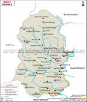
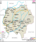
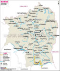
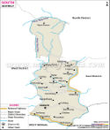
The district of North Sikkim is bestowed with natural scenic beauty. There are many places of tourist attraction in the district like Mangan, Chungthang, Lachung, and Yumthang.
Important Places in North District
Mindo, Lungma, Kambe, Donkung, Nakpolatok, Naku, Gogong, Oakra, Laten, Cheora, Olo, Nachungthangka, Chorten Labsang, Goma, Pukchhang, Phuring, Theulacha, Rangsha, Goma, Thanggu, Yume Samgang, Shawaphi, Yathang, Talam, Burumkhancha, Chimakaru, Phyaktol, Lahungthosa, Ratiomthang, Lachung, Yumthang, Shabrung, Annual Fair, Latong, Yuigang, Tolung Gompa, Shabrung, Laven, Lingthem, Lingdong, Gyathang, Kaliyo, Sangam, Pakel, Theng, Long Nadom, Shampung, Khedum
Last Updated on : June 24, 2026