

Latitude : 27.3 N
Longitude : 88.3 E
| |||||
 | |||||
|





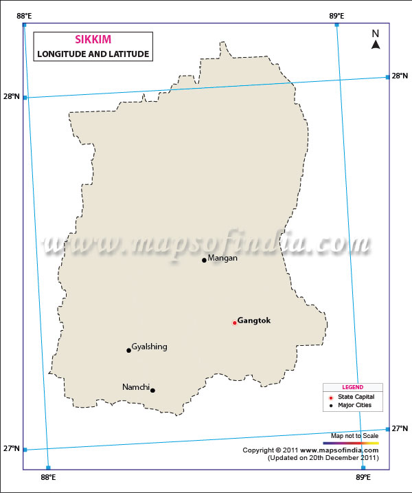
*The Map showing the Latitude and Longitude of the State Sikkim, India
Disclaimer: All efforts have been made to make this image accurate. However Mapping Digiworld Pvt Ltd and its directors do not own any responsibility for the correctness or authencity of the same.
Disclaimer: All efforts have been made to make this image accurate. However Mapping Digiworld Pvt Ltd and its directors do not own any responsibility for the correctness or authencity of the same.
Explore State Latitude and Longitude: Latitude and Longitude Finder
Sikkim is a small landlocked state in the eastern part of the Himalayas of India. It lies in the strategically important area of the Himalayan region, surrounded by Nepal in the West, Bhutan in the East, West Bengal to the south, and the Tibet Autonomous Region of China to the North. The Latitude and Longitude Map of Sikkim helps in identifying the state's exact geographical position on the globe, and it also serves as a good reference for the state's position, extent and its relation with the neighbouring areas.
The Sikkim latitude and longitude map shows the state falling between the 27.3° North latitude and 88.3° East longitude. The map offers a geographic reference point for Sikkim and is useful for students, research scholars, travellers, map users, & for anybody interested in studying the geography of Sikkim. The latitude and longitude of Sikkim provide a precise geographical reference for locating the state on maps.
Latitude and Longitude of Sikkim
The geographical extent of Sikkim lies between 27°04′ North latitude and 28°07′ North latitude, and 88°00′ East longitude and 88°55′ East longitude. The state is located north of the Tropic of Cancer and between the mountains of the eastern Himalayas.
Latitude is the measure, in degrees, of an angle between a location and the equator, and longitude is the measure, in degrees, of an angle between a location and the prime meridian. These coordinates can be combined to give an exact way of pinpointing a location on the Earth's surface. The geographical coordinates of latitude and longitude can thus be used to pinpoint the geographical location of Sikkim in the Northeast region of India.
The approximate central coordinates from the Maps of India page are 27.3°N latitude and 88.3°E longitude. The geographical position of Gangtok, the capital of Sikkim, is at 27.20° N latitude & 88.40° E longitude.
Geographical Extent of Sikkim
The geographical area of Sikkim is approximately 7,096 square kilometres, and the size of Sikkim is about 114 km x 64 km from North to South and East to West respectively. Despite its relatively small area, the state has considerable variations in elevation and terrain.
The north-south trend is especially important in view of the fact that the latitude and elevation interact to shape the climate, vegetation, settlement, and natural features of the state. There are sharp contrasts between the lower hills and valleys in the south and the higher mountains and snow-covered regions in the north.
The coordinates plotted on a Sikkim latitude longitude map also give an idea of how the state is between the Himalayan ranges and is a very narrow mountainous territory. The site has influenced its unique natural and cultural associations with adjacent parts of the Himalayas.
Sikkim's Location in India
Sikkim is located in the north-eastern part of the Indian state and is also bordered by international boundaries all around. Nepal is to the west, Bhutan is to the east, and the Tibetan region of China is to the north. Sikkim's southern border is shared with West Bengal, and it is the main land link with the rest of India.
Sikkim is an important Himalayan state both in geographical and strategic aspects due to its location. From ancient times, the passes, valleys, rivers and high elevation geography of the state have linked it to Tibet, Bhutan, Nepal and the plains of India.
The geographical coordinates also separate Sikkim from other northeastern states. Sikkim is located on the narrow width of the Himalayas between latitude 27° to 28 °N and longitude 88° to 89 °E, unlike many other states further east.
Physical Geography and Coordinates
The latitude and longitude of Sikkim are closely linked with its unique physical features. The state features high passes, steep mountains, deep valleys, forests, rivers and lakes. It is over a very small geographical area, and the elevation is quite variable, resulting in a wide range of climatic and ecological subzones.
As per the Sikkim Government, the state is a land of dramatic contours - rugged mountain peaks, deep valleys including dense forests, rivers, lakes and waterfalls. There are tropical, temperate and alpine regions in the state.
The northern landscape is dominated by the Greater Himalayan ranges, with lower hills and valleys more noticeable towards southern Sikkim. The State's geographic landscape is characterized by the presence of Khangchendzonga, one of the world's highest mountains, which is also the highest point in India. Sikkim's physical landscape is dominated by the mountain and the high-altitude area surrounding it.
Rivers and Natural Features
The geographical location of Sikkim is also significant from the perspective of the river systems of the region. The two main rivers in the state are Teesta and Rangeet. The Rangeet rises in the western part of North Sikkim, and the Teesta is a high-altitude branch from the western part of North Sikkim, flowing southwards. The two rivers finally converge near Melli, and the combined flow heads towards the plains of West Bengal.
There are also several glaciers and high-altitude lakes in Sikkim. These natural features are closely related to the high elevations and mountainous terrain of the state. Because of latitude, relief and altitude, the geographical landscape is varied.
Importance of the Sikkim Latitude and Longitude Map
A latitude and longitude map of Sikkim is useful for understanding more than just the state's coordinates. It provides a geographic foundation for studying its location in relation to India, neighbouring countries, mountain ranges, cities, rivers, and other physical features. The map can be particularly useful for:
- Identifying the exact geographical position of Sikkim.
- Understanding Sikkim's location within India.
- Studying the state's northern, southern, eastern, and western extent.
- Locating Gangtok and other important places using geographic coordinates.
- Understanding the relationship between latitude, longitude, terrain, and climate.
- Supporting school and college geography projects and map-based studies.
- Helping travellers and researchers understand Sikkim's position in the eastern Himalayas.
Latitude and Longitude of Gangtok
Gangtok is the capital as well as an important administrative and commercial centre of Sikkim. The latitude and longitude of Gangtok as per the Maps of India are 27.20 N latitude and 88.40 E longitude.
Gangtok is significant as a reference point when studying the Sikkim latitude longitude map, which is situated in the eastern part of the state. The mountain landscape surrounding the city and the importance of its several destinations and geographical features of the state.
Why Sikkim's Coordinates Matter
Geographical Coordinates are crucial for pinpointing a spot on a map and in digital mapping applications. The coordinates of Sikkim are used to describe the state irrespective of map projections or scales used.
The coordinates are helpful to the student for geography classwork and map work. Latitude and longitude provide assistance for geographic analysis, surveying, navigation, environmental studies and spatial planning for researchers and planners. In the mountainous state, the coordinates are also a new way for travellers to comprehend the location of the destinations.
In general, the Latitude and Longitude Map of Sikkim provides a geographical point of reference for the location of Sikkim in the eastern Himalayas. The unique physical and climatic features of Sikkim can be attributed to its location between latitudes 27°04′ N and 28°07′ N and longitudes 88°00′ E to 88°55′ E and to its varied topography and altitude. The latitude and longitude of Sikkim are therefore important for understanding its geographical position and physical setting.
FAQs
Q1: What are the latitude and longitude of Sikkim?
Sikkim is located approximately at 27.3° N latitude and 88.3° E longitude. The state extends from about 27°04′ N to 28°07′ N latitude and 88°00′ E to 88°55′ E longitude.
Q2: Where is Sikkim located on the map of India?
Sikkim is located in the eastern Himalayas of northeastern India. It shares borders with Nepal, Bhutan, China, and West Bengal.
Q3: What are the latitude and longitude of Gangtok?
Gangtok, the capital of Sikkim, is located at approximately 27.20° N latitude and 88.40° E longitude.
Q4: What is the geographical extent of Sikkim?
Sikkim covers an area of approximately 7,096 square kilometres. It extends about 114 km from north to south and 64 km from east to west.
Q5: Which countries border Sikkim?
Sikkim shares international borders with Nepal in the west, Bhutan in the east, and China in the north. West Bengal borders the state to the south.
Q6: Why is the latitude and longitude map of Sikkim important?
The Sikkim latitude and longitude map helps identify the state's precise geographical location, extent, and position in the eastern Himalayas. It is useful for geography, mapping, research, and navigation.
Q7: What are the coordinates of Sikkim?
The approximate coordinates of Sikkim are 27.3° N latitude and 88.3° E longitude. These coordinates help locate the state accurately on maps and digital mapping platforms.
Last Updated on : August 24, 2026
| Location | Latitude | Longitude |
| Gangtok | 27.20 N | 88.40 E |
Latitude and Longitude of Indian States & UT's
