


Telangana Road Network
Telangana is the 29th (the newest) state of India, coming into existence on June 2, 2014. Earlier it was a part of the state of Andhra Pradesh. It comprises of an area carved out of the ten north-western districts of the former state of Andhra Pradesh, which are Adilabad, Nizamabad, Karimnagar, Medak, Warangal, Khammam, Rangareddy, Hyderabad, Nalgonda and Mahbubnagar. The region shares its border in the North and North-West with that of Maharashtra. To its West lies Karnataka, while Chhattisgarh occupies its North-East side. To the East, it is surrounded by Odisha.
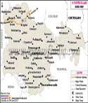
National Highways in Telangana
Around 6 national highways form a large network of roads in the state. These highways interconnect every district, making journey from one town to another a smooth affair. The longest national highway that crosses Telangana is NH7, which enters the state from its North, starting from Adilabad and going on to Mahbubnagar before exiting the state on its South. Along the way it touches the important districts of Nizamabad, Medak, Rangareddy and Hyderabad, the capital of the state. The Hyderabad city would serve as the joint capital of both Telangana and the rest of Andhra Pradesh for ten years.
NH9 crosses the state, surpassing Hyderabad, Medak, Nalgonda and Rangareddy along its way. In Andhra Pradesh it passes through Zahirabad, Suryapet, Narketpally, Vijayawada, Kodad and Machilipatnam.
NH16 in the state passes through the important towns of Karimnagar, Adilabad and Nizamabad. This national highway crosses NH7 at Nizamabad before ending at the district HQ. NH222 is the shortest of all the national highways in the state which touches only Adilabad district of the state. NH202 stretches from Hyderabad to Warangal. NH221 is another important national highway that passes through Khammam.
Last Updated on : May 29, 2014
Roads Map of Telangana