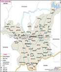
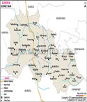
Udham Singh Nagar District Map |
|
||||||||||

|
||||||||||
|
| *Map showing National Highway, Major Roads, District Headquarters, Major Towns, Rivers and etc in Udham Singh Nagar District. |
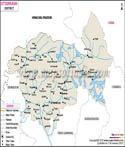
| Major Districts of Uttarakhand |
 |
 |
 |
 |
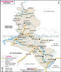
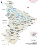
| Uttarkashi District Map | Dehradun District Map | Nainital District Map | Tehri Garhwal District Map |
 |
 |
 |
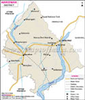 |
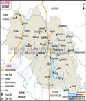
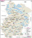
| Almora District Map | Pithoragarh District Map | Chamoli District Map | Haridwar District Map |
| other districts of Uttarakhand >> | |||
About
One part of Uttarakhand that stands out is Udham Singh Nagar, formed in 1995 when it split from Nainital. This land honors the revolutionary Udham Singh through its name. Flat, lush fields stretch across the area, sitting right in the green Terai zone. Because the ground holds so much life, farming thrives here more than in many northern regions. Rice grows tall beside golden wheat, while sugarcane and pulses fill the rest. That deep earth feeds both people and markets, shaping how the state earns.
The main office for the district sits in Rudrapur, a place that's grown into an industrial hotspot. Thanks to SIDCUL's growth, factories and plants have spread quickly here, pulling in businesses from across India and beyond. Farming still runs alongside these industries, shaping an economy unlike many others around. Trains roll through regularly, roads link up neatly - movement feeds trade more than anything else could.
History and Culture
Rooted in movement of people, farming growth, followed by recovery plans after freedom, this place evolved slowly. Long before 1947, thick woods mixed with wetlands stretched across the zone - nestled where mountains meet plains. Few lived here because sickness spread easily plus roads and homes were missing. Then colonial times began shifting things: trees came down so soil could grow crops instead.
Not long after the Partition of India in 1947, a big shift took place as families - many from Punjab, including Sikh groups - began building new lives here. Thanks to their efforts, farming changed fast; fresh methods turned dry ground into rich fields ready for crops. While that was happening, others arrived too - not just from nearby areas but also Uttar Pradesh and Bengal, bringing different ways of living together. By 1995, this area became its own district, called Udham Singh Nagar to remember how he stood up for independence.
What stands out most is how different backgrounds blend here, shaped by people from many ethnic roots. Not just one faith finds space - lives unfold through Hindu, Sikh, and Muslim ways without friction. Celebrations like Diwali, Holi, Eid, and Baisakhi light up communities, each marked with similar energy. Taste it in meals, see it in attire, hear it in music - Punjabi life pulses at the core.
Music shifts block by block, one neighborhood pulsing with bhangra beats, another circling to gidda rhythms, while farther off, Kumaoni melodies rise like morning smoke from hearths.
Food here tells a story of mixed traditions. Not just roti, rice, and lentils from North India, but also Punjabi flavours like sarson da saag with makki di roti show up on many tables. Dishes brought by migrants add more layers to daily meals. In every bite, you taste how lives have woven together over time.
Economy
This area's economy stands among Uttarakhand’s strongest, built on farming mixed with growing industries. Thanks to its spot in the lush Terai belt, farming holds up village life here. Deep alluvial dirt plus steady weather helps crops thrive. Wheat grows widely. So does rice. Sugarcane spreads across fields. Pulses appear too - oilseeds and greens round out what farmers harvest. People often call it the state’s food hub because so much comes from these lands.
Farms work better when water comes through canals or underground sources. Thanks to people who arrived after independence, machines and new methods now help grow more food. Milk production and raising chickens add value to village livelihoods.
Beyond farming, factories have reshaped how money flows here. Thanks to SIDCUL setting up shop near towns like Rudrapur, Sitarganj, and Pantnagar, big names from across the country and overseas started moving in. Car makers, drug producers, food packagers, fabric weavers - each brought jobs, pulling more people toward cities. Because of these clusters, one thing became clear: this place now hums with making things others rely on. Northern India watches closely as workshops and plants turn quiet land into busy ground.
Goods move easily here thanks to solid roads and train routes. Town hubs such as Rudrapur and Kashipur buzz with farm output trading hands alongside factory-made items. Being close to Uttar Pradesh and nearby regions adds weight to business ties across borders. Connections grow stronger when neighbors trade more.
Tourism
Fewer visitors come here than to Uttarakhand's mountain areas, though temples, green views, and closeness to big tourist spots give it weight. Sitting across the Terai stretch, it mixes holy places with chances to see animals and explore nature up close.
A well-known place of worship sits at Giri Sarovar in Kashipur, pulling followers in every season. This small city carries weight from long-ago times, tied by belief to early human habitation. Not far off stands Atariya Temple, alive with pilgrims when yearly festivals spark movement across surrounding areas.
Just beyond lies the well-known Jim Corbett National Park, tucked into the neighboring Nainital area. Travelers moving across often pause here before heading into the reserve, drawn by dense forests teeming with life - tigers most of all. Being so close gives this place a quiet role in how people explore nature around these parts.
Green farms and pockets of trees in the Terai open doors to nature-based travel, along with glimpses into village life. What you see here stands apart from the high peaks most people link with Uttarakhand. Harvest times bring color and rhythm that lift the land’s quiet appeal. A different face of the state shows itself when fields glow under seasonal change.
Folks heading through often find a place to rest right where roads meet - Rudrapur or Kashipur - with shops nearby, places to stay, and ways to keep moving without delay. Tracks laid long ago still carry people in and out while buses roll on schedules just as steady.
Demographics
One thing about this place stands out right away - cultures mix here like nowhere else nearby. Though small on the map, people keep moving in, drawn by jobs and open fields. Back when the last headcount happened in 2011, more than 1.6 million already called it home. That number packed tightly into towns and villages makes it busier than most others across Uttarakhand. Fertile soil pulls farmers, factories pull workers, so crowds grow without slowing down.
The people come from many different backgrounds. Waves of movement shaped this - especially once India split into two nations. People arrived from places like Punjab, then later from Haryana and areas west of Uttar Pradesh. From Bengal too, folks made their way in, adding more layers. One thing became clear: nobody holds majority status here.
Folks here follow many religions, though most practice Hinduism, while others lean toward Islam or Sikhism.
Most people speak Hindi when dealing with official matters or just chatting day to day. Still, Punjabi pops up a lot, especially within Sikh families and Hindus from Punjab. You might hear Kumaoni, Bengali, or even Urdu too, thanks to where folks originally came from. All these tongues mixing together shows how different backgrounds fit under one roof here.
Even now, the balance between men and women stays just under the country's usual mark - something seen across much of north India.
City living matters more now. As factories spread through SIDCUL zones, settlements swell fast - drawing workers from many places. Because of that shift, town numbers climb without pause even though country spots still live off farming land.
Administration
Running things here depends on a setup meant to keep decisions clear, progress steady, besides safety managed. Oversight comes from the larger state power based in Uttarakhand, placing control firmly in district hands. Leading that effort is the District Magistrate, known locally as the DM, taking charge across daily operations. Keeping peace falls to them first, along with rolling out new rules from above plus watching construction projects grow. Working beside them stands the Senior Superintendent of Police, often called SSP, holding watch over officers and quiet inside borders.
Broken up for easier management, the area splits into chunks like Rudrapur, Kashipur, Kichha, Sitarganj, Gadarpur, Jaspur, and Bajpur. Leading each chunk, an SDM takes charge of tax gathering, property details, along with everyday local tasks. With these smaller units, decision power spreads out, making it quicker for people on the ground to get what they need.
From town to village, daily oversight happens via elected city and countryside groups. While cities like Rudrapur rely on municipal councils and corporations, their work centers on clean streets, steady water flow, alongside road upkeep. Out in farming zones, small village assemblies take charge - these Gram Panchayats steer progress projects, listening closely to what locals ask for. Power shifts downward here, shaped by tradition yet tied to modern rules for growth.
One seat in the Lok Sabha includes this area, linking it to national politics. Inside its borders sit multiple assembly segments, each picking a voice for the state legislature. Through these sections, choices reach higher levels of government. Representation here flows both ways, shaping laws on different scales.
Down at the district level, different arms of government handle tasks like health care, schooling, farming support, one after another. Industrial activity gets extra scrutiny because SIDCUL areas are active there, so officials keep a steady watch to maintain order. These zones need consistent management, otherwise operations might stumble.
| Facts of Udham Singh Nagar District | |
|---|---|
| State | Uttarakhand |
| District | Udham Singh Nagar |
| Area (km2) | 2542 |
| Division | Kumaon |
| Population | 3,198,982 |
| Named After | Udham Singh |
FAQs
Q1: How many villages are there in the district?
688 villages.
Q2: What is the population of the district?
3,198,982.
Q3: What is this district famous for?
Agriculture (rice and wheat), industrial hubs (SIDCUL, Rudrapur), Terai farming, and diverse migrant culture.
Last Updated on : May 08, 2026
| Buy this Map |