
Introduction
The Uttarkashi district is considered to be among the most important and geographically memorable districts of the Indian state of Uttarakhand which is placed in the Garhwal region of the western Himalaya. Reputed by its religious significance, the rugged landscape and untouched natural elegance makes the district a crucial aspect in the upper Ganga basin and this is a sacred place in Hindu heritage pilgrimage.
The physical features that characterize the land are high mountain ranges, but deep valleys, glaciers and thick forests, which precondition such a character of the terrain and make it a very picturesque and strategically significant district. It borders Tibet (China) on the north and Himachal Pradesh to the west and internally, other Uttarakhand districts are Chamoli, Tehri Garhwal, Rudraprayag and Dehradun.
Uttarkashi is more or less referred to as the entrance to some of the most religious pilgrimage destinations in India, with Gangotri being one of them that is regarded as the origin of the River Ganga. It is also a starting point of various trekking paths, mountain climbing, ecological research. The landscape is a formidable factor but allows a small population who mainly relies on agriculture, pastoral life and tourism. The 2011 Census recorded that the population of the district is approximately 330,086 but it has low population density because of geographical features, mountains.
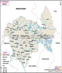
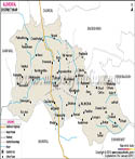
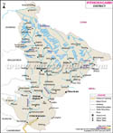
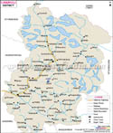
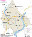
The Uttarkashi district map is regularly engaged to figure out the complicated topography, river regime as well as settlement plans that characterize the area. A map of the Uttarkashi district comes in handy especially in imagining and mapping the Bhagirathi valley and related settlements.
History
The history of the Uttarkashi district is closely connected with the historical development of the whole territory tested by the Garhwal region. The region has been inhabited since the times immemorial, and it can be strongly related to the mythology of the Hindu religion, sages, and the tradition of the ascetic way of life. It is held that penance was done here by numerous sages and the Himalayan valleys in the higher parts have traditionally been a sacred land.
Historically, the area was a part of the Tehri Garhwal kingdom, which governed most of the current Uttarakhand until the mid-20 th century. Uttarkashi district is an administrative unit formed on official basis on 24 February 1960 by subdivision of Uttarkashi parts of the former Tehri Garhwal district especially the Rawain and Uttarkashi parganas.
Uttarkashi town is also of ancient origin and has always been regarded as a great religious centre. The district was named after its spiritual connection with Varanasi because all the two are situated between two rivers that share the same names Varuna and Asi. At Uttarkashi the rivers are symbolized by local streams that reflect the geographical sacredness of the plains.
Throughout centuries, there were the impressions of different dynasties and the local chieftains in the region. Large-scale invasions were commonly curtailed by the rough landscape that gave native cultures and traditions opportunity to thrive rather undisturbed. Regional behaviour was not significantly altered but the British colonial period involved administrative restructuring, road construction and some modernisation to a small extent of the region.
Uttarkashi district map will prove to be a valuable resource to historians as they trace out historical routes, trade links and patterns of settlements. Geography and its role in political boundaries and governance is also revealed in the Uttarkashi district map. Moreover, the Uttarkashi district map would facilitate in the realization of the strategic importance of the region especially when it was in connection with the closeness to Tibet. The Uttarkashi district map also depicts the allocation of ancient pilgrimage routes which have been in existence since ages.
Culture
The culture of the Uttarkashi district is a funky mixture of the traditional Garhwali traditions, religious influences and the local tribal influences. The district is mainly Hindu and spirituality, rituals and festival are very closely emphasized. Temples and pilgrimage sites dominate the everyday life, and the observations of religion are involved deeply in the culture of the country.
The linkage with the Char Dham pilgrimage, especially Gangotri is one of the characteristics of the Uttarkashi culture. Every year thousands of pilgrims come to the district, and there is made a culture of both a devotional and hospitable character. Old fairs and festivals like Makar Sankranti and villagers temple festivals are also celebrated with passion and in most cases followed by folk music and dancing.
The district has another different indigenous community such as Bhutia tribe in the elevated areas. The cultures of these communities and the specifics of their clothing and way of life are related to the severe conditions of the Himalayan environment.
Another aspect of art and craft is found in the Uttarkashi region in terms of wool weaving, wood carving and traditional architecture which is adapted to the mountainous climate. The cultural identity is closely related to nature where most rituals are devoted to rivers, mountains and forests.
The map of Uttarkashi district gives an understanding of the areas of distribution of cultural regions and village settlements. The Uttarkashi map of the district also contributes in the recognition of pilgrimage centres and villages with old customs which are still followed. The Uttarkashi district map also shows the role played by geographical isolation in ensuring that the in-depth cultural identities are preserved. Uttarkashi district map remains an ideal source of cultural diversity information in the district.
Language
The Uttarkashi district has linguistic diversity which can be shown by language. The official and administrative language is Hindi which is well comprehended in the district. Nevertheless, the language most commonly used by the local residents is Garhwali that is an essential component of the cultural heritage in the area.
As census data demonstrate, most of the population are Garhwali speakers, and Hindi is their lingua franca that allows uniting various communities. There are other languages that are also spoken like the Nepali and some Tibetic languages especially the border and high-altitude regions.
Dialectal variations additional to the linguistic landscape also do not spane valley to valley since the place is geographically isolated. These discrepancies add to the peculiarities of the oral traditions in the region, folk songs and storytelling traditions.
The linguists usually study the space distribution of languages and dialects through the Uttarkashi district map. The Uttarkashi district map is used to explain the impact of the terrain on linguistic differences and the patterns of the communication process. In addition, the Uttarkashi district map identifies the regions with the presence of minority languages and dialects. Uttarkashi district map is an effective tool of comprehending how geography and language relate in the district.
Geography
The topography of the Uttarkashi district is characterized by the mountainous landscape, high altitude mountains, glaciers and rivers. It is also unique in that it spans one of the largest areas in Uttarakhand and is marked by extreme altitude and climate variations in the area which covers a total of about 8,016 square kilometres.
The district is situated in the high parts of the Himalayas and it has the Greater Mountain Range and the Lesser Mountain Range. The district is a source of the Bhagirathi River which starts in the Gangotri Glacier and serves as a lifeline to the district. The area is also well endowed with forests, alpine meadows and biodiversity.
Uttarkashi has got extremely cold winters with snowfall in elevated areas and relatively mild summers. The monsoon is associated with heavy rain, and this in some cases may result in landslides because of the weak mountain ecosystem.
Uttarkashi district map is also critical to the terrain and river system that is complicated. More so, the Uttarkashi district map helps in getting the path of trekking, pilgrimage path and isolated settlements. The Uttarkashi district map still remains as an important resource to any geographer, planners, and travellers.
Besides the mountainous topography, Uttarkashi district has some high-layered glacial systems that are critical in the hydrology of the northern India. There are many smaller glaciers and snow-maker streams to feed the river network which maintains downstream ecosystems and human settlements. The Uttarkashi district map comes in very handy specially in pinpointing these glacial areas and the location from which the glaciers are in relation to the river basins and valleys. Snowmelt variations in seasons play a significant role in determining the amount of water especially in the flow of water, and hence studying of these glaciers is important in the management of water resources and climate studies.
One more significant feature of the Uttarkashi geography is the ecological diversity of the region in the form of subtropical forests at low altitude to the apline vegetation in the high altitude. The region has diverse plants and animals with some being Himalayan endemics. Forest divisions and other well-preserved areas are essential in preserving biodiversity as well as managing the requirements of the local people. The Uttarkashi district map assists in identifying forest cover, the location of wildlife and the regions of wildlife conservation in varying altitudes. It also helps the researchers and administrators to track environmental changes, evaluation of the effects of human activity and design sustainable development programs into this environmentally sensitive area.
| Facts of Uttarkashi District | |
|---|---|
| Official Name | Uttarkashi District |
| Area | 8,016 km² |
| Population | 330,086 (As of 2011) |
| Language | Hindi, Garhwali, Nepali |
| Religion | Predominantly Hinduism |
FAQs
Q1: What is Uttarkashi district famous for?
Uttarkashi district is famous for its religious significance, especially the Gangotri pilgrimage and Himalayan landscapes.
Q2: When was Uttarkashi district formed?
Uttarkashi district was established on 24 February 1960.
Q3: Which river flows through Uttarkashi?
The Bhagirathi River flows through Uttarkashi district.
Q4: Why is Uttarkashi called the Kashi of the north?
It is called the Kashi of the north due to its religious importance and similarity to Varanasi’s sacred geography.
Last Updated on : May 08, 2026
| Buy this Map |