On 8th September 1962 the Chinese made their first incursion into Indian Territory in the Eastern sector. A 60 people strong People’s Liberation Army (PLA) began occupying positions which dominated one of India’s posts. There was no gunfire initially, but later the then Prime Minister of India Pandit Jawaharlal Nehru said that the Indian Army had instructions to “free our territory” and the troops were given the freedom to exercise their judgment to use force whenever they found it necessary.
However, on 11th September 1962 when the Chinese incursions did not stop the patrols were given the permission to fire at any armed Chinese who entered Indian Territory. This was the beginning of what came to be known as the Sino-Indian war which began on 20th October 1962 and lasted till 21st November 1962.
The reason for the Sino-Indian war was cited to be a disputed Himalayan border, but there were several other factors which contributed to this war as well. The Tibetan Uprising in 1959 gave rise to many gruesome border incidents, because Indian had given asylum to the Dalai Lama.
A Forward Policy was initiated by India under which it had posted small army camps a little distance away from the main force, to guard the nation against a surprise attack. Many of these outposts were posted north of the McMohan Line, the Eastern Position declared by Chinese Premier Zhou Enlai in 1959.
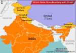
One of the main causes of the Sino-Indian War was the dispute over the geographically separate Aksai Chin and Arunachal Pradesh border region. India claims Aksai Chin to be a part of Kashmir, while China considered it to be part of Xinjiang. Aksai Chin contains a crucial road link which connects the Chinese territories of Tibet and Xinjiang. One of the major reasons of the conflict was the construction of this road.
Apart from the conflict between Aksai Chin, other areas which led to the war were the borders shared by Himachal Pradesh and Uttarakhand with Tibet. Disputed areas included Shipki La and Kauri in Himachal Pradesh and areas such as Thag La, Barahori, Kungri, Bingri La, Laptal and Sangha. China also laid claim to 90,000 sq miles of territory in Arunachal Pradesh, such as Tawang, Bum La, Asaphi La and Lo La.
The conflict regarding the border between India and China has existed since time immemorial. One of the fist incursions took place in October 1959 when the Chinese army crossed the Sino-Tibetan border and moved towards Lhasa. Following that in May 1954, India and China signed the Panchsheel Treaty (Five principles of peaceful co-existence). Despite this in January 1959 Chinese Premier Zhou Enlai lays claim to more than 40,000 sq miles of Indian territory in Ladakh and NEFA (present day Arunachal Pradesh).
Talk to sort out the border issue in April 1960 ended in a dead end and in September 1962 Chinese forces crossed the McMohan Line in the Thang La Region in the East and opened gunfire on Indian soldiers. On 20th October 1962 China launched an attack from various corners, all the way from Ladakh to Arunachal Pradesh. By 15th November 1962 Chinese attacked on the eastern front, invading Tawang and Walong. By 18th November 1962, the Chinese army had captured Bomdi La in the NEFA Region.
Since the PLA had reached the claim lines it did not advance any further and on 19th November 1962, China declared a cease fire. The cease fire came into effect on 21st November 1962, following which firing along the border stopped and from 1st December 1962 Chinese troops began withdrawing 20 km behind the Actual Line of Control (LoAC) between both countries.
After the war India increased its support towards the Tibetan refugees, some of whom had settled in India. The Sino-India war is notable for the harsh conditions under which it was fought. Combat took place at an altitude of 4,250 meters. During the war, neither country deployed the Air Force or Navy.
Later in 1993 and 1996 both India and China signed the Sino-Indian Peace and Tranquility Accords agreeing to maintain peace and harmony along the LoAC.
Also on This Day:
1320: Ghazi Malik was hailed as Sultan.
1952: The first World Convention of Copyrights was signed at Geneva by 35 nations, including India.
1960: Feroze Gandhi, Indira Gandhi’s husband passed away.
1998: Vijaypat Singhania, Chairman of the Raymond Group and a keen aviator, reached Ahmedabad from London in his micro-light single aircraft, thereby creating a world record.