For several decades after independence, Arunachal Pradesh was largely cut off from much of India’s development. Given its mountainous geography, land covered by dense forests, and a landscape that is subject to almost continuous landslides. The construction of roads was both prohibitively difficult and expensive. Additionally, given the sensitivity of the location, the central government was cautious to develop too quickly for fear of negative Security considerations based on the history of Chinese incursions in the early 1960s.
The 1962 Sino-Indian War was pivotal in highlighting the vulnerability of India's northeastern frontiers. Roads have subsequently been prioritised by the government in Arunachal Pradesh. This not only impacts economic integration but also demonstrates territorial sovereignty.
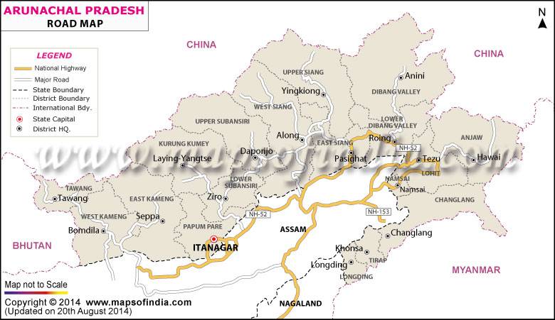
The Trans-Arunachal Highway (TAH)
The Trans-Arunachal Highway is arguably the most ambitious and transformative infrastructure project in the state, and it is a 2,407 kilometre long corridor from Tawang in the west to Kanubari in the east. The goal for TAH was to serve as the backbone of road transportation across the state, linking 16 districts and connecting small towns and villages that were previously isolated.
The project is a combination of National Highways NH-13 and NH-15 and connects strategic locations such as Bomdila, Seppa, Ziro, Daporijo, Along (Aalo), and Pasighat. The implementation of the project has been hampered by land acquisition, environmental clearances, and the difficult terrain. However, in 2023, a vast majority of the road is operational, and the remaining segments will be completed shortly. The Trans-Arunachal Highway is responsible for better access to healthcare, education, and markets for remote communities, resulting in an altogether better quality of life.
NH-13 Sela Tunnel (All Weather Strategic Connectivity)
The NH-13 portion of the Trans-Arunachal Highway is crucial to connect western Arunachal Pradesh with mainland India. An important part of NH-13 is the Sela Tunnel, which was completed in 2024. The 1.5 km Sela Tunnel is at an elevation of 3,000 meters and bypasses the dangerous Sela Pass, a pass that is snowbound for several months every year. The Sela Tunnel provides all-weather connectivity to Tawang.
Tawang, which has a border with China, is of great strategic significance. The Sela Tunnel will enable years of travel time and relatively year-round troop movement and civilian access in Tawang. The Sela Tunnel is an engineering achievement and further demonstrates India's infrastructure capabilities and connectivity in sensitive border areas.
Arunachal Frontier Highway
The suggested Arunachal Frontier Highway (AFH) shall be yet another impactful project. The AFH will be almost 1,748 km along the Indo-China border, providing an additional transport route along a proposed LAC route. The route is likely to start at Bomdila and end at Vijaynagar in Changlang District.
Once completed, this route is intended to be a parallel transport route to the LAC and while it is a very important strategic initiative, it would also provide access to previously inaccessible hinterlands of the state. The amount of logistics preparation to build the AFH is truly enormous; there are challenges within the ecological sensitivity of many of the areas it shall traverse as the majority shall generally fall under wildlife sanctuaries or forests.
Importance of road development and national security
Due to its strategic distance from China, Arunachal Pradesh is a major piece of India’s national security. The Doklam standoff in 2017 and border skirmishes thereafter have highlighted the pressing need for robust infrastructure in the frontier areas. Structures such as the TAH, the NH-13, and the proposed AFH enable the Indian Army to mobilize effectively in the event of an emergency.
Further, infrastructure acts as a psychological deterrent; it signals India’s commitment to its defence of its territorial claims. The creation of satellite towns along the border, later supported by enhanced transport corridors, roads, railways, and airports, etc. also forms a part of India’s strategy on border management.
Tourism Potential and Cultural Integration
The development of road infrastructure in Arunachal Pradesh has emerged as a powerful enabler for tourism and cultural integration in one of the most geographically isolated and ethnically diverse states in India. Arunachal Pradesh is home to more than 25 major tribes and over 100 sub-tribes, including languages, customs, and festivals. A vibrant, living example of the wealth of cultures in India. It was because of the limited access and poor transportation infrastructure that relegated this rich source of ethnic diversity beyond the reach of India and the world. The expansion and modernization of the "crossroads" represented through key projects such as the Trans-Arunachal Highway, Sela Tunnel, and proposed Arunachal Frontier Highway will unlock the state's rich tourism potential and provide access to this cultural diversity, in which national consolidation is vibrant.
One of the most direct impacts of road development has been the opening up of remote and picturesque destinations. Tawang, Ziro, Mechuka, Bomdila, and Namdapha National Park have seen remarkable increases in the number of both domestic and international visitors. The ability for visitors to quickly travel by road to explore beautiful valleys, high altitude lakes, monasteries, and national parks is safer than ever before.
For instance, Tawang is home to the second-largest monastery and is immersed in Tibetan Buddhist culture. The Sela Tunnel boosts all-weather connectivity to Tawang, a drought of connectivity that previously almost entirely curtailed the drifting nature of the travel time and access to tourism, particularly facet winter months. The Trans-Arunachal Highway is another such important road that connects the central and eastern parts of the state's tourism potential - a place like Ziro Valley, for example, that is largely known for the Ziro Music Festival and UNESCO nominated Apatani tribal cultural landscape.
Road systems have enabled grassroots tourism models such as homestays, guided tribal tours, and eco-tourism initiatives, which not only sustain the indigenous people’s culture but also provide sustainable livelihoods. Tourists can now interact with the local tribes and participate in local festivals such as Losar, Solung, Nyokum, and Mopin, as well as eat authentic food, which is all now much easier due to road connectivity.
Road development reduced travel time as well as ensured hassle-free logistics, has greatly enhanced the tourist industry and persuaded government and the private sector to upgrade tourism facilities (rest houses, facilities, waypoints and information centres) and all in turn enhances the tourism economy through improved supply-side inducements.
More than the economic benefits that improved road networks bring, the cultural integration process is nuanced and deep. Mobility brought about by improved road connectivity has facilitated the capacity of people in the rest of India to experience cultural diversity in Arunachal Pradesh, thereby reducing a significant dimension of cultural understanding. The local communities are also slowly being integrated into the national mainstream culture at the same time, without completely erasing their cultural identity.
Educational exchanges, cultural festivals, and interstate tourism schemes have increased due to better roads. Projects under the Swadesh Darshan Scheme, which build conceptual thematic tourist circuits, have aimed to connect tourism with cultural heritage. For example, the Bhalukpong-Bomdila-Tawang circuit has taken center stage with regard to Buddhist heritage tourism, which has drawn interest from local Indians and foreign tourists as well.
FAQs
Q.1: What is the Arunachal Pradesh road map and what is its significance?
The Arunachal Pradesh road map refers to a planning initiative for road system development to improve connectivity throughout the state. Given the rugged geography in the area, difficulty of reaching remote villages, and location where a state borders two countries, road development will be necessary for economic integration as well as for strategic defense. The Arunachal Pradesh road map includes key projects such as the Trans-Arunachal Highway, the Sela Tunnel, and the proposed Arunachal Frontier Highway, and the goal is to connect the western, central, and eastern regions of the state in a timely manner.
Q.2: What implications does the Trans-Arunachal Highway have for the state’s connectivity?
The Trans-Arunachal Highway is over 2,400 kilometers in length and has become the backbone for the state’s transportation network. The highway connects important administrative town stations such as Tawang, Ziro, Aalo, Pasighat, and Roing, allowing for an increase in intra-state travel which continues to improve exceedingly well. The Trans-Arunachal Highway also reduces travel time, travel costs, and supports the speed at which our resources can arrive with the speed of a response, or needed logistics for disaster relief, whether natural disasters, medical emergency response, or issues relating to borders.
Q.3: In what ways has road improvement positively changed the lives of local communities?
The improved road network has been a game changer for day-to-day life in Arunachal Pradesh. The availability of ambulances, mobile medical units, and school buses means that access to healthcare and education is vastly improved. Farmers and artisans are able to get their products to market more easily and increase their incomes. Roads have also allowed greater access to government schemes and administrative services, which in turn reinforces governance and the presence of the state in remote areas.
Last Updated on : June 24, 2026