
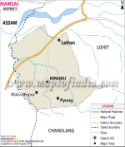
Arunachal Pradesh is an important state in Northeast India. The district maps of Arunachal Pradesh show all the districts that make up the state. It is one of the Seven Sister States of India. The districts of Arunachal Pradesh function as the administrative subdivisions of the state.
About the districts of Arunachal Pradesh
The state of Arunachal Pradesh is made up of 16 districts. Every district of the state is governed by a district collector who also looks after the requirements of the regional population. Given below are the names of the 16 districts of Arunachal Pradesh:
- Changlang District
- Tirap District
- Anjaw District
- Lohit District
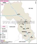
- Upper Dibang Valley
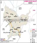
- Lower Dibang Valley
- West Siang District
- East Siang District
- Lower Subansiri District
- Upper Siang District
- Kurung Kumey District
- Upper Subansiri District
- East Kameng District
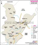
- Papum Pare District
- Tawang District
- West Kameng District
Information about the districts of Arunachal Pradesh
Given below are some important facts and figures about the districts in Arunachal Pradesh:
| District | Headquarters | Code | Population (2011) | Density (/km2) | Area (km2) |
|---|---|---|---|---|---|
| Anjaw | Hawai | AJ | 21089 | 6 | 3234 |
| Changlang | Changlang | CH | 147951 | 27 | 4662 |
| East Kameng | Seppa | EK | 78413 | 14 | 4134 |
| Pasighat | East Siang | ES | 99019 | 22 | 4005 |
| Lohit | Tezu | EL | 145538 | 13 | 2402 |
| Lower Subansiri | Ziro | LB | 82839 | 10 | 10135 |
| Papum Pare | Yupia | PA | 176385 | 42 | 2875 |
| Tawang Town | Tawang | TA | 49950 | 19 | 2085 |
| Tirap | Khonsa | TI | 111997 | 42 | 2362 |
| Lower Dibang Valley | Roing | UD | 53986 | 4 | |
| Upper Siang | Yingkiong | US | 33146 | 5 | 6188 |
| Upper Subansiri | Daporijo | UB | 83205 | 8 | 7032 |
| West Kameng | Bomdila | WK | 87013 | 10 | 7422 |
| West Siang | Along | WS | 112272 | 12 | 8325 |
| Upper Dibang Valley | Anini | 7948 | |||
| Kurung Kumey | Koloriang | 89717 | 7 |
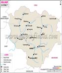
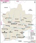
Anjaw district
Anjaw district is a newly formed district. The district headquarters are located in Hawai. It is the easternmost district in India. The major rivers in this district are as follows:
The major harvests include millet, maize, beans, rice, orange, cardamom, plum, pears, and apple. The divisions of the district are Hawai, Hayuliang, Goiliang, Manchal, Kibithoo, Walong, and Chaglogam.
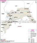
Changlang district
The headquarters of Changlang district are located in Changlang. The four subdivisions of the district are Miao, Changlang, Bordumsa, and Jairampur. The district houses the Namdapha Tiger Reserve.
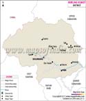
East Kameng District
East Kameng district has its headquarters in Seppa. The two subdivisions of the district are Chayangtajo and Seppa. These are further divided into the following areas: Sawa, Chayangtajo, Bameng, Khenewa, Gyawe Purang, Lada, Seppa, Pipu, Pijirang, Richukhrong, Seijosa, Pakke-Kessang, and Dissing Passo. The district is famous for the Pakhui Tiger Reserve.
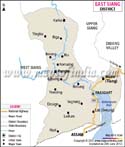
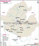
East Siang district
The headquarters of East Siang district are located in Pasighat. The five legislative assembly constituencies of Arunachal Pradesh situated in this district are Nari-Koyu, Panging, Pasighat East, Pasighat West, and Mebo. The district houses the D'Ering Memorial (Lali) Wildlife Sanctuary.
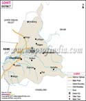
Lohit district
The administrative headquarters of Lohit district are located at Tezu. A major subdivision of this district is Namsai. The four assembly constituencies coming under this district are Chowkham, Tezu, Lekang, and Namsai. The district is known for the Kamlang Wildlife Sanctuary.
Lower Subansiri district
The government headquarters of Lower Subansiri district are situated at Ziro. The six administrative circles forming this district are Ziro (Sadar), Pistana, Yachuli, Kamporijo, Raga, and Dollungmukh. It houses two assembly constituencies: Ziro-Hapoli and Yachuli. There are three blocks in the district: Tamen-Raga, Ziro-I, and Ziro-II. The Lower Subansiri district is home to the Tale Valley Wildlife Sanctuary.
Papum Pare district
Papum Pare district is the most populated district in the state. It was formed in 1999. The two subdivisions of this district are Yupia Capital complex and Sagalee. The district is again subdivided into nine administrative circles and they are Leporiang, Mengio, Toru, Sagalee, Doimukh, Kimin, Tarasso, Balijan, Itanagar, and Naharlagun. Doimukh, Itanagar, and Sagalee are the three assembly constituencies in the district. The famous Itanagar Wildlife Sanctuary is located in this district.
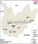
Tawang district
The district headquarters of Tawang district are located in Tawang town. The three subdivisions of this district are Lumla, Tawang, and Jang. The district houses three assembly constituencies: Tawang, Lumla, and Mukto.
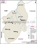
Tirap district
The administrative headquarters of Tirap district are located in Khonsa. The district houses seven assembly constituencies: Khonsa East, Namsang, Borduria-Bogapani, Khonsa West, Longding-Pumao, Kanubari, and Pongchau-Wakka.
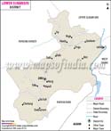
Lower Dibang Valley district
The government headquarters of Lower Dibang Valley district are located in Roing. Dambuk and Roing are the two assembly constituencies in this district. The Mehao Wildlife Sanctuary is located in this district.
Upper Siang district
The administrative headquarters of this district are situated in Yingkiong. Mariyang-Geku and Tuting-Yingkiong are the two assembly constituencies in this district. Mouling National Park is a part of this district.
Upper Subansiri district
The headquarters of Upper Subansiri district are located in Daporijo. Taliha, Nacho, Raga, Daporijo, and Dumporijo are the five assembly constituencies in the district.
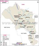
West Kameng district
West Siang district
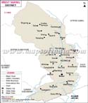
The headquarters of West Siang district are located in Along. Likabali, Liromoba, Along East, Along West, Mechuka, and Rumgong are the assembly constituencies in the district. The Kane Wildlife Sanctuary lies in this district.
Dibang Valley district
The headquarters of Dibang Valley district are located in Anini. It is the biggest district in the state and is home to one assembly constituency: Anini. The Dibang Wildlife Sanctuary lies in this district.
Kurung Kumey district
Kurung Kumey district has its headquarters in Koloriang. Nyapin, Palin, Koloriang and Tali are the four assembly constituencies in the district.
List of Districts in Arunachal Pradesh
| Sr. No. | District | District HQ | Population (2011) | Growth | Sex Ratio | Literacy | Area (km2) | Density (/km2) |
|---|---|---|---|---|---|---|---|---|
| 1 | Anjaw | Hawai | 21167 | 14.19% | 839 | 56.46 | 6190 | 3 |
| 2 | Changlang | Changlang | 148226 | 18.18% | 926 | 59.8 | 4662 | 32 |
| 3 | Dibang Valley | Anini | 8004 | 10.07% | 813 | 64.1 | 9129 | 1 |
| 4 | East Kameng | Seppa | 78690 | 37.62% | 1029 | 60.02 | 4134 | 19 |
| 5 | East Siang | Pasighat | 99214 | 13.52% | 980 | 72.54 | 3603 | 27 |
| 6 | Kurung Kumey | Koloriang | 92076 | 116.56% | 1032 | 48.75 | 6040 | 15 |
| 7 | Lohit | Tezu | 145726 | 16.59% | 912 | 68.18 | 2402 | 28 |
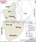
| 8 | Longding* | Longding | * | * | * | * | * | * |
| 9 | Lower Dibang Valley | Anini | 54080 | 7.20% | 928 | 69.13 | 3900 | 14 |
| 10 | Lower Subansiri | Ziro | 83030 | 49.00% | 984 | 74.35 | 3508 | 24 |
| 11 | Papumpare | Yupia | 176573 | 44.73% | 980 | 79.95 | 2875 | 51 |
| 12 | Tawang | Tawang Town | 49977 | 28.40% | 714 | 59 | 2085 | 23 |
| 13 | Tirap | Khonsa | 111975 | 11.61% | 944 | 52.19 | 2362 | 47 |
| 14 | Upper Siang | Yingkiong | 35320 | 5.87% | 889 | 59.99 | 6188 | 5 |
| 15 | Upper Subansiri | Daporijo | 83448 | 50.78% | 998 | 63.8 | 7032 | 12 |
| 16 | West Kameng | Bomdila | 83947 | 12.53% | 819 | 67.07 | 7422 | 12 |
| 17 | West Siang | Along | 112274 | 8.04% | 930 | 66.46 | 8325 | 23 |
Last Updated on : June 24, 2026