

|
||||||||||
| ||||||||||
|





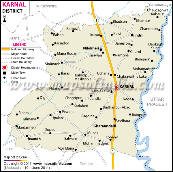
| *Karnal District map showing National highways, district headquarter, roads, towns, etc. |
About
Situated in northern Haryana, Karnal district stands out as a key hub for both agriculture and history. Fertile soil defines much of its landscape, supporting crops that anchor the region's rural economy. Karnal city, serving as the district's main hub, operates as a key spot for administration, learning, and trade. Growth here has come fast - not just in farming methods but also in built-up zones. Schools, clinics, shops, homes, and factories keep spreading, bringing jobs along with them. With each phase of development, more people find work while the local economy strengthens slowly. Carnival lights glow during Diwali, yet daily life holds steady in Karnal’s quiet lanes. Though skyscrapers rise near farmland, village speech keeps Haryanvi alive. Instead of fading, old customs blend into new routines.
History and Culture
Long before modern times, Karnal took form through shifts that mirrored those seen across northern India. Positioned on key ancient pathways, it slowly gained significance due to constant flow of people and goods. Karnal might take its name from Karna, the famed figure of the Mahabharata, as tradition holds. This area could have been shaped by his presence, some stories say. Because of such tales, the land links deeply with India’s early past. Though scholars question the proof, people still value the bond today.
The reign of dominance in the region changes over time. It went in the hands of Rajput and then to the Mughals. Under Mughal rule, it became part of the broader imperial framework. Local structures came to be reorganized. Colonial oversight followed much later, new forms of bureaucratic management were introduced.
Strategically positioned, the area rose in significance through both Mughal and colonial times. Under imperial oversight, transport routes stretched further, shaped by growing administrative needs. Irrigation channels spread across farmland, quietly transforming how crops were grown. Roads, once basic tracks, evolved into vital links that boosted farming yields alongside commerce.
Later, schools helped shape political thinking across Karnal. Though quiet at first, conversations about change grew louder over time. Because of shared goals, people joined protests tied to national efforts elsewhere. From early on, town meetings fed into larger waves sweeping north India.
Years after freedom came, fields in Karnal began shifting fast - fueled by the Green Revolution. With new techniques emerging alongside better water access, yields climbed sharply. Seed upgrades played a role, just like science centers focused on crops. Progress here didn’t slow; it pushed Karnal into the front rank among Haryana’s farm regions.
Festivals matter deeply here. Color spills into the streets when Holi arrives, pulling neighbors together. As night falls during Diwali, lamps glow in houses, shops brighten, joy spreads without announcement. Among women, especially where fields stretch beyond roads, Teej carries weight handed down through years. When Krishna's birth is marked, crowds appear - Janmashtami draws them quietly. Dussehra follows, gathering people again, not forced but expected.
Economy
Karnal thrives through farming, schools, factories, commerce, alongside service sectors shaping its economic base. Though rooted in crops, learning institutions add steady momentum. Manufacturing enters the picture where exchange of goods grows. Services evolve slowly yet contribute meaningfully. Each part connects without relying on one single source.
Government Sector
From district offices to hospitals, public sector jobs emerge across services run by officials. Schools and colleges offer roles managed under state oversight. Law enforcement units operate with staff hired into structured positions. Welfare programs rely on personnel placed within community frameworks. Healthcare delivery depends upon teams organized through regional planning. Administration at local levels functions using appointed individuals.
Public Sector
Across the district, progress relies on services run by government bodies, hospitals, schools, financial institutions, plus transit networks shaping daily life. Farming assistance programs along with development initiatives boost regional economies more broadly. Though often overlooked, these efforts create conditions where rural areas can thrive over time.
Services Sector
Steady growth marks the service industry across Karnal and nearby towns. Besides schools and colleges, shops also create jobs for many residents. Medical centers contribute alongside eateries that serve daily customers. Transport firms operate continuously, linked closely with telecom providers. Hotels support livelihoods too, forming part of this broader network. Each business type adds value in its own way. Employment rises as these sectors gain momentum together.
Though modest in size, local factories add value to the regional economy. From milling grains to preparing food products, these operations keep production active across sectors. Instead of large corporate setups, many rely on simpler machinery and nearby labor. Some make packages for goods, others repair tools used on farms. Construction supply workshops operate alongside them, forming a network of small producers. Their combined output helps maintain steady economic movement at ground level.
With cities growing, new openings have appeared across shops, home building, banking tasks, alongside learning programs run by non-public groups.
Fueled by farming vitality, growth in city-based services pushes Karnal's economy forward. While fields remain productive, new business activity in towns adds momentum. Progress emerges not just from soil but also shifting daily needs. Rural output pairs with evolving infrastructure, shaping financial trends. Change unfolds quietly where crops meet commerce.
Tourism
Starting off with ancient sites, Karnal district includes places of worship alongside serene water bodies. Gardens blend into the mix, offering green spaces near learning centers. Temples stand close to spots tied to past events. Water features sit beside areas built for study. Places linked to history appear throughout, often near spots meant for reflection or education.
Around here, Karna Lake stands out as a notable site. People come looking for leisure, drawn by open water and quiet shores. Linked to tales from the Mahabharata, it carries weight beyond scenery alone. A stretch of open greenery sits downtown - Karna Park draws families seeking relaxed outings. Though urban, its lawns stay busy most days.
A key player in dairy science, the National Dairy Research Institute sits in Karnal. Its presence strengthens the area's role in education. Not just a lab hub, it shapes training and innovation across India’s milk sector. This institution adds weight to the region’s learning landscape. Through research, it quietly influences national agricultural progress.
Regional dishes served in familiar settings create moments people remember. Shopping for spices, baked goods, or handmade treats adds texture to the journey. These everyday places shape experience more than expected. Festivals throughout the year bring people together around shared customs. These events grow naturally from local ways of living. Community bonds strengthen when traditions are celebrated openly. Moments like these root culture in everyday experience.
Demographics
In 2011, Karnal recorded nearly 15 lakh residents during the national count, positioning it as a notable region within Haryana due to demographic weight and progress. Rather than being purely city or countryside, its identity emerges through coexistence - villages rooted in agriculture stand beside towns gaining size over years. Life in many areas still turns on crop cycles; fields dominate routines where families depend mainly on cultivation for income. Yet shifts occur: cities grow slowly, altering how people live, work, and access institutions tied to learning, commerce, support roles, enterprise.
Across Karnal district, Hindi appears most frequently in speech, forming the base for official work, schools, and routine interaction. Within rural areas, talk often shifts toward Haryanvi forms, where tradition supports its steady presence among residents. In some zones, voices carry Punjabi words - echoes of cultural overlap and community variety take shape there instead.
Over recent decades, education systems have grown without pause, leading to better reading abilities and broader societal growth. Close to 75 percent of people in the region now possess basic literacy skills - a change shaped by schools, policy efforts, and rising value placed on attending classes. Learning centers ranging from primary schools to vocational programs have broadened availability, reaching towns as well as remote locations. Even though certain regions still face uneven access or inconsistent teaching standards, long-term gains remain evident through higher numbers of literate individuals.
Rooted in age-old farming practices, Karnal also sees gradual expansion of city-like structures. Life in villages unfolds slowly, guided by seasons, harvests, because shared rituals hold communities together. On the contrary, urban zones gain momentum through better transport networks, schools appear more frequently, medical access improves gradually, commerce spreads without fanfare. Instead of replacing old patterns, new developments layer over them quietly. Tradition does not fade here - rather, it shifts shape under quiet pressure from evolving needs and steady construction alike. Identity forms not from one force alone, but how fields meet pavement across generations.
Administration
Karnal holds the role of main administrative hub for the district. While functioning as a central node, it manages regional governance tasks. Its position supports coordination across local institutions. With steady operations, oversight extends through surrounding areas. Authority flows through its established offices. Governance here shapes daily civic functions.
Karnal stands out among the main subdivisions, along with Assandh shaping the region's layout. Gharaunda plays a role just as Indri contributes to administrative structure. Nilokheri appears consistently in discussions of local hubs, while Nissing completes the set through its presence across records.
Around 400 villages lie within the district, scattered through farmland and towns that grow slowly outward. While farming shapes much of the land, pockets of city-like development appear where movement increases. Overseeing schools falls under administrative duties, while medical services are managed locally. Support for farmers emerges alongside road building, each tied to regional oversight. Clean water systems appear where governance extends, often paired with social aid efforts. Policing connects deeply to these functions, forming part of daily civic structure.
City management prioritizes roads, utilities, and buildings alongside education or healthcare access. Meanwhile, transit networks shape how people move through metropolitan areas. Development strategies often reflect population growth patterns. Planning processes include zoning laws that guide construction projects across districts. Still rolling out initiatives, government offices focus on schooling, support for women, medical services, job creation, yet updates to farming practices.
| Official Name | Karnal |
| Location | Haryana |
| Area | 2520 sq. km |
| Population | 1505324 |
| Language | Hindi, Haryanavi |
FAQs
Q1: How many villages are there in the district?
There are 435 villages in Karnal district.
Q2: What is the population of Karnal?
The population of Karnal according to the 2011 census is 1505324.
Q3: What is the district famous for?
Karnal district is famous for rice production, agriculture, Karna Lake, dairy research institutions, and its role as one of Haryana’s leading farming regions.
Last Updated on : July 10, 2026
