

|
||||||||||
| ||||||||||
|





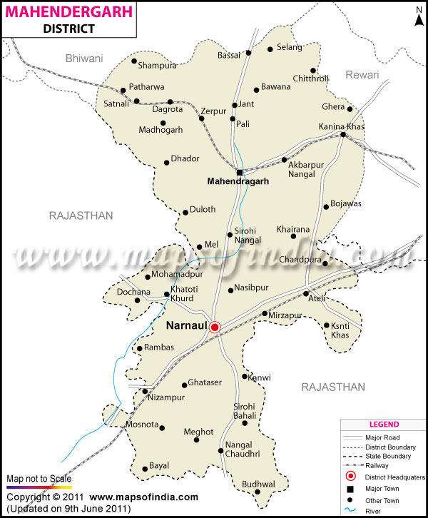
| *Mahendragarh District map showing National highways, district headquarter, roads, towns, etc. |
About
Mahendragarh is among the historic districts of Haryana state in India. The District is situated in the South-Western part of the state, bounded by the State Rajasthan and also with several Districts of Haryana like Rewari, Charkhi Dadri and Gurugram. The district is known for its long history, educational institutes, agricultural economy and army heritage. When talking about the structure of geography, means of transport, settlement pattern in Mahendragarh district, many students, travellers and researcher often use this Mahendragarh district map. The administrative area of the district is 1900 km² and situated in the semi-arid conditions of the south of Haryana. Rocks, low hills, agricultural plains and clumps of forest make up the landscape. The education and infrastructural development as well as the strategic location of Mahendragarh makes it significant. The Mahendragarh district map is being used mostly to understand the commutation network as well as Tehsils and other important tourist spots are dotted in all directions.
History & Culture
Mahendragarh district has a rich and historical heritage. The District takes its name from Maharaja Mahendra Singh of Patiala who had been prominently involved in 19th Century administration of the area. The area has been part of various Rajput States in the past and later, under various Delhi Sultanates, Mughals and the Princely rulers. The headquarters town of Narnaul is an important town for trade, military and architectural aspects. The heritage of the district still stands testimony to the architectures of various ruling families: wall of old buildings, forts, tombs and Step wells. For the locations of historical settlements, forts and heritage monuments throughout the district, the Mahendragarh district map is referred. The district has a deep connection with Indian military conventions also. Many citizens of Mahendragarh have been serving for many generations in Indian Armed Forces for various generations. This martial tradition is a significant part of the local identity and social pride. The area is also linked to a number of folk practices and oral histories that are related to bravery, sacrifice and rural life. Historical sites such as villages and areas within the Mahendragarh district map can be helpful in identifying the parts of the district that hold historical significance with regards to historical military involvement and heritage. Culturally Mahendragarh does reflect tradition of southern Haryana and Ahirwal region of the area. Cultural heritage, attire, music and social life are highly influenced by the Ahirwati and Haryanvi culture. The traditional folk songs, dances and the agricultural fairs are still very much in evidence as a major feature of cultural celebrations. There are various festivals, like Holi, Diwali, Janmashtami, Teej and Makar Sankranti which are observed with great enthusiasm across the district. During festive seasons, there are also regularly rural sports, wrestling competitions and community gatherings. Local dishes consist of bajra roti, churma, kheer and many other dishes with milk and dairy, based on the agriculture lifestyle of the region. There is deep roots of religious and spiritual traditions in the district. Devotees from neighboring localities and states flock to the Temples, Shrines and ancient pilgrimage centres. Mahendragarh has maintained a balance between the passage of time and developing educational progress and rural conventional values, while becoming culturally different from other parts of Haryana.
Economy
The economic activities of Mahendragarh District are mainly agriculture, government jobs, education and small scale commercial activities. In general agriculture is still the mainstay in the livelihoods of rural population where crops like Mustard, Wheat, Bajra, Barley and Gram are grown extensively throughout the district. Farming activities are supported with irrigation facilities and tube wells and rainfall in the district during the rainy season, which has a semi-arid climate. The Mahendragarh district map is a document that is referred to by farmers and agricultural planners for information on irrigation networks, cultivation zones and village level distribution of agriculture. The Government Sector has a significant contribution in the economic structure of the district. The government schools, colleges, administrative offices, police and medical services offer significant jobs. Educational institutions, particularly, have worked to foster economic growth in recent years. Development of Universities and Colleges in and around Narnaul and Mahendragarh town has promoted educational development and promoted employment to the people in the town. Institutional planning for roads and educational institutions in either rural or urban areas, as well as public welfare schemes, also uses the Mahendragarh district map. The Public Sector contributes in the realm of infrastructure development, transport services and public utilities. The connectivity in the district has contributed with state funded schemes for rural electrification and drinking water supply and road construction activities.The connectivity in the district has resulted from the state sponsored schemes related to rural electrification, drinking water supply and road construction activities. With the development of the railway connectivity, trade and transport have been enhanced in the region along the railway line at Narnaul & other nearby towns. Rural infrastructure investments are ongoing in areas such as public works and development agencies with the goal of enhancing the economic opportunities within the rural community. The steady growth in the Services Sector over the last decade has been impressive. Today there are new sectors that have become significant in the economic landscape: banking, retail trade, transport services, telecommunications and educational coaching centres. In towns like Ateli, Mahendragarh and Narnaul small businesses and local markets cater to the commerce of the towns and employ the residents as well. There are also tourism-related services that are related to the heritage sites and pilgrimage destinations in the district that contribute in small amounts to the district's economy. Besides, there are numerous inhabitants from the district to be working in the army, educational institutes and private enterprises throughout India which can provide stability to the households of the district. Due to the rocky terrain of the Aravalli region some parts of the district are having mining activity and some industries related to stone. But they are not eliminated from shaping business growth in regards to environment and sustainable development issues. In a general context, the economy in Mahendragarh is a mixture of agriculture, public employment, education, and the increasing service-based economy.
Tourism
There are several historical, religious and natural wonders of Mahendragarh too which are the sources of tourism to the place throughout the year. This is because the architectural past of the town derives the township to be one of the most important tourist centres of district. The influence of Mughal and medieval era has been reflected in historical monuments like Chor Gumbad, Jal Mahal, Birbal Ka Chhatta and Shah Quli Khan's Tomb. The travellers consult the Mahendragarh district map every now and then when exploring these monuments and charting their way from one monument to another. Apart from the large monuments, this district also has temples, rural heritage sites and natural landscape natural to the Aravalli hills. The villagers can attend village fairs and festivals; and they can enjoy the culture and hospitality of the Haryanvis. People visit religious centres of their worship as well as their saints from a distance. Tourist facilities are being gradually developed in the district, improvement of roads, system of accommodation and transportation.
Demographics
According to the census data of 2011, population of Mahendragarh district was around of 922088. Nearly 77.72 per cent of the people in the District were literate, which is nearly the same level as many other Districts of the region. There are around 485 people per square kilometre. Planners and researchers frequently use the Mahendragarh district map to investigate settlement pattern, concentration of the rural population in the district and urbanization processes. The main language used in the district is Hindi, with Haryanvi also being extensively used and Ahirwati as another language used for everyday communication. The traditional identity of rural communities remains strong but there are more languages spoken in educational centres and towns due to educational development and urbanisation. The district has a combination of rural and urban population with a significant population segment residing in the villages and depending on agriculture or allied activity. In social aspects of the district, there exists the culture of the people of Ahirwal area of Haryana.
Administration
Mahendragarh district is divided into various tehsils and blocks for further effective implementation of governance and development of the district. Some of the important tehsils are Narnaul, Mahendragarh, Ateli, Kanina and Nangal Chaudhary. The Mahendragarh district map is largely adopted for revenue administration, public service delivery, administrative planning and infrastructure planning at Tehsils which comes under the Mahendragarh District of the Government of India. It has over 350 villages and several towns and Municipalities. The village administration is exercised by gram panchayats and the urban administration is handled by municipal bodies. Updated version of the Mahendragarh district map is still an indispensable document for demarcation of villages, roads & other developmental areas within the Mahendragarh district. However, the district has its headquarters in Narnaul and it is the main administrative, educational and commercial centre. Politically the district is represented in Assembly by the following constituencies of the state: Narnaul, Mahendragarh, Ateli and Nangal Chaudhary. The overall aim of public administration is geared towards rural development, services to welfare, education, healthcare and road infrastructure, and agriculture's upswing. In recent years the government's work to improve the area's literacy, infrastructure and employment opportunities have been beneficial in the district.
FAQs
Q1: How many villages are there in Mahendragarh district?
Mahendragarh district has more than 350 villages according to administrative and census records.
Q2: What is the population of Mahendragarh district?
According to Census 2011, Mahendragarh district had a population of approximately 922,088 people.
Q3: What is Mahendragarh district famous for?
Mahendragarh district is famous for its historical monuments, Dhosi Hill, military heritage and Ahirwal culture.
Last Updated on : July 17, 2026
