


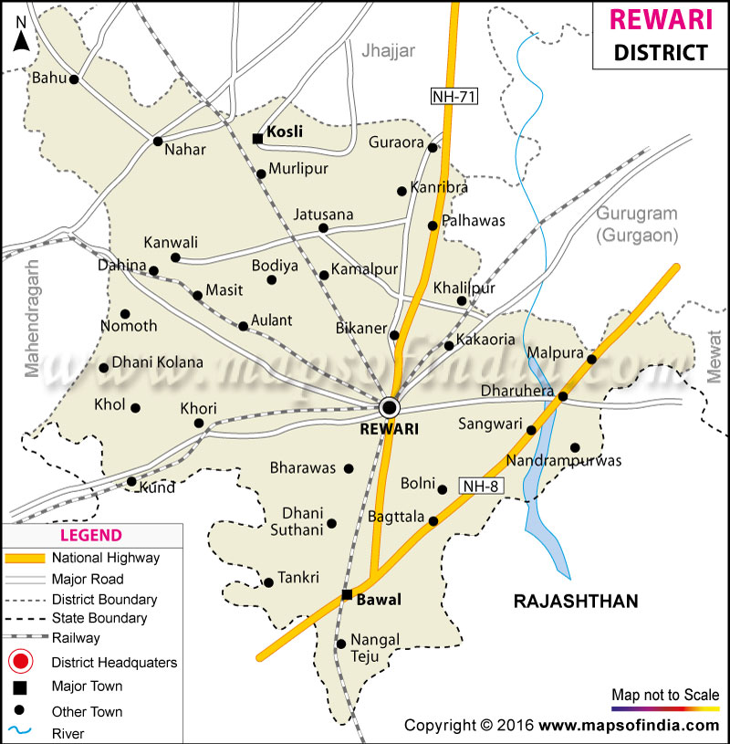





Rewari district is one of the important districts in south region of the state of Haryana of India. As it is so near to the capital region it has acquired a significant administrative, trading, educational and industrial importance in the region. Equipped with proper connectivity to all major cities like Delhi, Gurgaon, Jaipur etc. through road and rail, the district is being headquartered in the city of Rewari. The strategic location of the district has been an important contributor to the economic and social growth in the district during the years. A number of students, travellers and researchers use the Rewari district map to get an insight into the geographical location, transportation system and population distribution in Rewari in India.
History & Culture
Rewari district has a rich historical background, which not only bears testimony of Haryana but also embody the legacy of north-western India. The region has historical past with references to prehistoric settlements, as well as historical trade routes, dating back for centuries. Rewari was under the rule of several other Rajput and other regional dynasties in the medieval era and later was under the Delhi Sultanate and Mughals. It became prominent during the reign of Rao Tula Ram, one of the prominent freedom fighters of the Revolt of 1857.
The resistance was led by Rao Tula Ram who was a prominent leader in the organisation of the fight against the British regime and has been crowned a hero of Haryana history. In studies of the past, and educational activities to record the location of events pertaining to the 1857 rebellion the Rewari district map is frequently utilized. Apart from that the Rewari district map also shows the whereabouts of the traditional villages and old trade routes, which were important for the history of the district.
Rewari district is rich with the culture of Haryana merged with the influence of Rajasthan's culture. The folk music, traditional dance forms and local fairs are still a vital aspect of social life. Haryanvi is used in a large number of rural areas and Hindi is being used in the administration and education. Distinctive features of Haryanvi and Rajasthani language are also present in local dialects.
The district celebrates various festivals such as Holi, Diwali, Teej, Makar Sankranti and Dussehra with great enthusiasm. At the time of festivals, rural communities hold festivals, wrestling and folk contest. The old customs and clothes are still followed during wedding ceremonies and gatherings. The district is also known to have military heritage with members of the Indian Armed Forces from various families serving in the military. This legacy has earned Rewari a reputation for patriotism and discipline.
Economy
Rewari district is quite diversified economy and comparatively developed in comparison to many other areas of Haryana. The district's economy is mainly to its agriculture, manufacturing and trade and services. It has been a great advantage to the district because of its nearness to Delhi and Gurugram, both having experienced a vast increase in industries and cities.The district has gained much due to its proximity to Delhi and Gurugram where a huge number of industries have prospered in the surrounding and increased urbanization. Rewari district map is often used by the investors and development planners to identify industrial corridors and transport connectivity and growth centres in the district area.
Government Sector
Rewari district is well-served by the government sector in terms of administration and development. The government has different departments that handle public welfare, agricultural support program, education, healthcare and rural development. The administrative staff at Rewari city co-ordinates the governance at district level and implements programs of state and central govts in the district.
The quality of life in the district has improved with public infrastructure like roads, irrigation system and educational institutions. As the Government schools, colleges and health centres are providing essential services to both urban and rural population. The Rewari District map is quite popular for planning authorities for developing the development of Roads, Public transport and the connectivity of the villages.
Public Sector
Development of industries and economic development in Rewari district has been promoted by the public sector. The district has been transformed by the industrial activity of the districts like Dharuhera and Bawal and has now become a hub of industrial development in Haryana. The industrial area consists of Auto manufacturing units, Engineering industries, Metal processing industries and ancillary production center.
The district is also linked with Delhi Mumbai Industrial Corridor to boost opportunities for investment and employment. The transport and industrial development in the district have been promoted through public investments and have encouraged private companies to set up operations in the district. The development of industrial estates and logistics infrastructure has facilitated the work of goods and bolstered the ties between the regions.
Services Sector
In recent decades, the increasing demand for urbanisation and the development of industrial activities has contributed in a significant way to the growth of the services sector. The district has a robust banking, education, health care, retail trade and transportation sector. Rewari city has grown into a business hub with educational institutes, markets and business establishments thriving to provide employment to its people.
Strategic position of the district close to the main road and railway ports is particularly relevant with regard to transport and logistics. Students from neighbouring districts also attend the educational institutions and coaching centres. The Rewari District Map will guide any business or service provider and will show connectivity between industrial towns, rural areas and urban centres.
In rural parts of the district agriculture still plays an important role for people's livelihood. Farmings of crops like wheat, mustard, bajra and gram is popular. Rural livelihoods obtain income also from dairy business and animal husbandry. In some areas of the district the use of modern farming practices and then irrigation has enhanced the productivity of the agricultural sector.
Tourism
The Rewari Steam Locomotive Shed is one of the most renowned and is known for its efforts in the preservation of the vintage steam locomotives. The heritage railway becomes a popular destination for railway enthusiasts and the tourists from all over India. The Rewari District map has been widely adopted by tourists for people to find the closest sites of interest, railway museums and sites of cultural heritage within Rewari district.
The memorial of Tula Ram in remembrance of another famous freedom fighter of 1857 is also another point of attraction. His legacy lives on and inspires people the state of Haryana. For the interested students of Indian Freedom movement, the locations of the Revolt of 1857 are in special interest.
Bawal and Dharuhera are not only the Industrial areas but also famous for urban activities and development of infrastructure and connectivity as a part of Kheri city. The cultural and traditional village settlements in some of the temples of the district are an expression of its cultural identity. Pilgrims come to religious centers for the festivals or religious activity; and worshipers visit religious centers for religious activities.
Apart from this, the district is also linked with the tourist centres in neighbouring hilly haryana and Rajasthan which makes it an important point for the traveller people. The tribal people, who celebrate their culture at traditional fairs, local markets and in rural areas, can be felt at their various rural places. The Rewari district map explores the new routes by which the researchers or tourists can visit the different villages or urban centres and the historic landmarks.
Demographics
The 2011 Census reported that Rewari district had a population of ~900,332. The district has experienced a consistent population increase since the time of industrialisation, urbanisation and the improvement of economic opportunities. Rewari is the major township and headquarters of the district. The Rewari district map is utilized in statistical studies and planning reports for analysing the population distribution and settlement patterns in the area.
Literacy rate in Rewari is round about 80.99 per cent, which is reasonably high as compared to other districts of the state of Haryana. There is a wider difference between male and female literacy rates, but in the most recent years improvements have been made with education for women. Some schools, colleges and technical institutes have partaken in the creation of awareness and educational training within the district.
Hindi is the District's official and the predominant language. Haryanvi is commonly used in villages and rural sectors as well as English is being increasingly used in educational, administrative and business sectors. In certain places the influence of neighbouring Rajasthani language is noticeable in the local dialects.
The district is a mixed rural–urban population district. Although agriculture still plays a significant role in the life of the villages, industrial activities and business are more prevalent in urban centres like Rewari, Dharuhera and Bawal. The Rewari district map has been found as useful in understanding the occurrence of urban settlements, industrial towns and agricultural villages.
Administration
Rewari district is administered by the Government of Haryana and administered as a part of Haryana's division form Gurugram in Haryana. Administratively the district has the Deputy Commissioner with the duties of maintaining law and order, coordination and implementation of various government projects and schemes.
From administrative perspective there are five tehsils such as Rewari, Bawal, Kosli, Nahar and Palhawas in the district. The tehsils are further divided into blocks and villages which are the administrative units to ensure proper functioning. The officials and the planners for rewar project use it as a Rewari district map while planning and administration.
According to the census there are about 403 villages throughout the district with varying administrative division which may vary slightly from time to time. The rural governance system is gram panchayat which plays prominent part in the development of villages and activities of sanitations and welfare of villages. It is further important to have a map of the Rewari district as it can be used to monitor infrastructure, transport and plan village wise etc.
FAQs
Q1: What is the total number of villages in Rewari district?
Rewari district has around 403 villages according to administrative and Census records.
Q2: What is the population of Rewari district?
According to the 2011 Census, Rewari district has a population of approximately 900,332 people.
Q3: What is Rewari district famous for?
Rewari district is famous for its industrial growth, heritage steam locomotive shed and the legacy of freedom fighter Rao Tula Ram.
Last Updated on : July 10, 2026
