

|
||||||||||
| ||||||||||
|





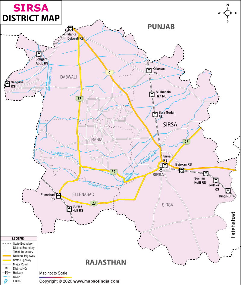
| *Sirsa District map showing National highways, district headquarter, roads, towns, etc. |
About
Situated near the edge of Haryana, Sirsa marks a quiet transition - where farming lands give way to dry terrain beyond. Rooted in older times, the district's title carries stories shaped by nature and power long gone. Green with dense thickets once stood here, locals say, thanks to clusters of Siris trees spreading wide under open skies. One version traces the label back through rulership - not foliage - with credit going to Raja Saras, known for shaping stone into defense. Built around 300 CE, his stronghold anchored influence where trade and travel crossed unnoticed borders. Where cultures meet across these lines, habits blend - ways of living, working, speaking - not neatly divided but woven unevenly over time. Size sets it apart: no other district in the state covers more land. Movement defines much of its role - goods pass through, people move along routes that cross here, linking parts of India otherwise distant in climate and custom.
History & Culture
Long before modern borders took shape, Sirsa stood within a landscape shaped by time and movement. Along the shifting course of what once flowed as the Ghaggar - linked through old traditions to the revered Sarasvati - signs of early settlements have emerged under careful digging. References appear in foundational writings; one epic from antiquity names it Sairishaka, describing towers, trade, and wealth held behind strong walls.
Positioned between major centers such as Delhi and Multan, its roads carried more than goods - they bore armies, rulers, and displaced crowds. With each passing era, conquest followed rebuilding, loss met renewal, often without pause. Through layers of soil and story, remnants tell of endurance, not just survival. A grim hunger spread across the land during 1783, emptying villages until fields lay silent beneath an open sky. By contrast, in 1838, order returned through Captain Thoresby - a British official - whose vision shaped a new settlement on old ground. Though ruin had ruled for decades, detailed layouts emerged slowly under his direction. From those beginnings rose a structured town, recognized fully only in 1867 as an established civic entity.
In Sirsa, culture unfolds through centuries-old ties between Hindu, Sikh, and Sufi ways of life. From this blend emerge speech habits, public events, and routines shaped by shared experience rather than division. Festivals here gather vast numbers each year - Baisakhi's arrival, the lights of Diwali, Teej’s rituals, alongside devotional gatherings at Sufi sites - drawing visitors across regions. Soundscapes rise from village courtyards: Punjabi rhythms drive Bhangra and Gidda, while Haryanvi voices carry tales in Saang performances and traditional songs.
Unity appears less as policy and more as rhythm, repeated daily without announcement. Cream dairy products, flat breads which are made from Millet and vegetables are grown in the garden itself. Apart from this most of the homes have homemade desserts which are rooted in the fertile farmland yield. Because of this balance between heritage and daily life the district has come to be known for the quiet reverence, shared gathering and the warmth which is offered freely in the villages as much as in the towns.
Economy
Deep within Haryana, Sirsa’s economy rests on rich farmland that feeds much of the region. Water flows steadily through canals linked to the Bhakra Nangal system, turning what was once dry ground into fertile fields. Crop yields here rank among the highest, especially for valuable harvests sold commercially. Alongside farming, factories slowly grow in number, adding new layers to local income sources. Shops and trade hubs hum with consistent activity, shaping another pillar of financial stability. Over time, tools and techniques have improved, boosting output without draining resources too quickly.
Government Sector
Stability in Sirsa leans heavily on government operations, offering jobs and shaping roads, buildings, and utilities across regions. With court systems spread throughout districts, alongside city councils and agencies managing social aid, oversight reaches deep into daily life. Health access takes form through large civil hospitals and clusters of small clinics reaching far into villages. From the ground up, medical services cover needs most often overlooked elsewhere. Anchored firmly in place, the Indian Air Force base near Sirsa fuels economic movement via supply chains and auxiliary businesses. Money flows in ways not always visible - through housing, transport, food, and repair work tied directly to military presence. Learning pathways emerge strongly under Chaudhary Devi Lal University's reach, employing educators and staff who shape minds.
Public Sector
Although often overlooked, government activity in Sirsa shapes access to finance, upkeep of roads, and reliable electricity supply. Branch networks run by state-owned banks reach deep into villages, supporting farm lending alongside local business initiatives through cooperative setups. Instead of private firms, power delivery relies on regional bodies like Uttar Haryana Bijli Vitran Nigam, keeping pumps active during crucial growing periods. Grain handling leans almost entirely on federal and state entities - Food Corporation of India among them - operating large-scale storage units scattered throughout the area. These facilities absorb harvest surges each season without relying on outside logistics support.
Services Sector
Growth in Sirsa's service industries now moves at an accelerating pace, driven by upgrades in shops, communication networks, delivery routes, along with money-handling operations. Because trains and highways meet here - linking Haryana to both Rajasthan and Punjab - movement of goods supports large numbers: drivers, cargo handlers, scheduling coordinators form its backbone. Banks, insurers, investment advisors have flooded into town, drawn by farmers’ rising incomes. Instead of only working fields passed down through families, young people increasingly find roles in crop consulting firms, tuition hubs, learning institutes run privately, medical testing labs opening across neighborhoods.
Tourism
Standing quietly at the edge of time, Gurudwara Chilla Sahib marks where Guru Nanak Dev once meditated for more than four months, sharing wisdom with Sufi mystics under open skies. Though centuries have passed, devotion still hums within its walls.
Among green fields rises Tara Baba Kutiya, less a single shrine and more a world apart - its grounds unfold slowly, revealing gardens trimmed with care, pathways lined with shade, then suddenly, the towering form of Lord Shiva carved high into view. At dusk, when light fades behind the 108-foot figure, silence settles like mist across stone steps and prayer halls alike.
Among quiet lanes and fading echoes of resistance stands Rania's aged fortress, once home to defiant leaders confronting invasions two hundred years ago. Hidden across the Ghaggar floodplain, weathered heaps of earth draw curious minds eager to uncover broken ceramics and sun-dried stones beneath their feet. Within Sirsa’s core stretches a wide stretch of green named after Bhagat Singh - paths wind through trees while children laugh near dancing jets of water under open skies. Older corners of settlement hold descending staircases carved long before modern pipes arrived, built when droughts shaped how people stored every drop they could gather.
Demographics
Looking closely at who lives in Sirsa reveals much about its people - rooted in village life yet touched by city expansion. Official data from 2011 counts precisely 1,295,189 residents here, showing growth of nearly 16 percent since ten years earlier. Spread across the area, around 303 persons occupy each square kilometer; this leaves room for wide farming fields despite rising numbers. Unlike busier parts of eastern Haryana, crowding remains limited. For every thousand men, women number 897 - a gap slowly narrowing due to health services and programs safeguarding girls through early years.
Although literacy continues to shape Sirsa's path forward, only 68.82% of residents were counted as literate in 2011. Men show higher participation here - 76.43% able to read and write - compared to women, where the figure drops to 60.40%. Close to the edge of three states, speech patterns shift subtly across villages. Punjabi and Haryanvi dominate daily conversation throughout most areas. In the south, near Rajasthan, voices often carry Bagri, a dialect rooted in Rajasthani tradition. Despite variety in spoken forms, one thread holds steady: Hindi runs through offices, schools, and government work, linking different groups without disruption.
Administration
Under careful oversight by the Deputy Commissioner, governance in Sirsa district flows clearly down to local levels through a well-ordered setup. Law enforcement, public order, and developmental initiatives fall within this official's scope of responsibility. Divided purposefully into four Tehsils, the area allows smoother handling of revenue tasks. Land documentation processes operate more efficiently due to this geographic segmentation. Local-level civil disputes find resolution closer to residents because administrative functions are decentralized. Each sub-unit acts as a core point for managing government affairs across its zone
Centered within the district lies Sirsa Tehsil, its biggest subdivision, where key government functions are based.
Near the northern edge, Dabwali Tehsil handles large-scale commerce linked to Punjab. Trade flows steadily across this frontier zone due to its strategic placement. Movement of goods defines much of the local economic rhythm here. Proximity to Punjab shapes how markets operate within the tehsil. Cross-border exchanges remain a consistent feature of daily activity.
Rania Tehsil oversees the ancient western parts of the region.
Situated near the Rajasthan frontier, Ellenabad Tehsil oversees farming areas in the south. Agricultural activity shapes daily life across these lands, guided by local oversight. Rural communities rely on seasonal cycles, adapting to shifting conditions. Governance here focuses on land use, water access, and crop sustainability. Patterns of cultivation reflect both tradition and environmental constraints.
Beneath the level of Tehsil governance, the countryside consists of 330 officially recorded census villages woven into an extensive, linked structure. Though spread out, these settlements cluster within distinct community development blocks. Within each block, elected village councils take charge of basic services - supplying clean water, extending electricity access, supporting elementary education
| Official Name | Sirsa |
| Location | Haryana |
| Area | 4277 sq. km |
| Population | 1295189 |
| Language | Hindi |
FAQs
Q1: How many villages are located within Sirsa district altogether?
Across Sirsa district’s wide terrain lie 330 officially recorded census villages, grouped under four administrative subdivisions known as tehsils.
Q2: How many people live in Sirsa district based on the latest census data?
1295189 people live in the district according to the 2011 census.
Q3: What is the district famous for?
Known widely for vast cotton and wheat harvests made possible through canal-fed farming, Sirsa stands out. Its past stretches into times told in the Mahabharata, giving weight to its long presence on the map. Places like Gurudwara Chilla Sahib hold deep spiritual meaning for visitors. So does the quiet site of Tara Baba Kutiya, often sought by those on personal journeys.
Last Updated on : July 17, 2026
