
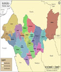
| Tehsil/Taluk Name | Total (Rural + Urban) Population (2001) in Number | Total (Rural + Urban) Population (2011) in Number | Pin Code |
|---|---|---|---|
| Aut | 26,873 | 30,973 | 175121 |
| Baldwara | 40,330 | 43,809 | 175033 |
| Bali Chowki | 33,663 | 37,906 | 175106 |
| Bhadrota | N.A | 21,627 | N.A |
| Chachyot | 50,435 | 57,740 | 175028 |
| Dharmpur | 30,898 | 34,783 | 175040 |
| Jogindarnagar | 75,675 | 84,440 | 176120 |
| Karsog | 83,379 | 93,102 | 171304 |
| Kotli | 23,941 | 25,858 | 175003 |
| Lad Bharol | 25,404 | 25,787 | 176126 |
| Mandi | 39,487 | 215,929 | 175001 |
| Nihri | 31,777 | 35,573 | 175038 |
| Padhar | 44,144 | 49,363 | 176121 |
| Sandhol | 18,443 | 16,917 | 176090 |
| Sarkaghat | 78,469 | 64,226 | 175024 |
| Sundarnagar | 101,437 | 111,232 | 174401 |
| Thunag | 44,106 | 50,253 | 175048 |
| Total | 748,461 | 999,518 |
Last Updated on : May 08, 2026