The state of Madhya Pradesh , which is situated in the central position of the state, is popularly known as the "Heart of India" and the "Central Province". Bordered by the state of Uttar Pradesh towards its north east, Rajasthan towards its north west, Gujarat towards its west, Maharashtra towards its south, Chhattisgarh towards its south east, the state covers a total area of 3, 08, 252 sq. km. As far as the area is concerned, this is the biggest state of the Republic of India.
Madhya Pradesh Physical Map
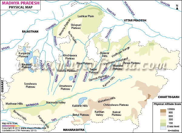
Similar to all the other physical maps of a given region, the physical map of Madhya Pradesh even assists one in gaining knowledge about the different topographical regions of the state. Color coded in different shades, each and every region varies from one another in terms of the elevation of a particular region from the level of the sea as well as the nature of the land in the respective regions. Each and every geographical variation is represented with different shades of color. The rivers and the other water bodies are being represented by the blue color though.
Physical Features of Madhya Pradesh
This central Indian state has got varied physical features, which is featured with mountain ranges, plateau regions, river valleys as well as plains. Two of the most famous mountain ranges in this state are Satpura range and Vindhya Range. Apart from that, a major portion of this state of India is covered by lush green forests and cultivated land. The different river basins form an important part of such a region of varied geographical features. Based on the climatic conditions, the total area of the state can be divided into the below mentioned topographies:
- The Chhattisgarh Plains
- The Hilly area of the Vindhyas range
- The Malwa Plateau
- The mountainous area of Bastar
- The Narmada River Valley
- The Northern Plains
Rivers in Madhya Pradesh
The state has got a number of famous rivers flowing through it. Thus, this place is the location of watersheds of many rivers as well as several river basins. Being located at the center of the country, the catchments of numerous rivers of the nation are located there. The Narmada River that is among the main river of the state meanders through the state from east to west. The other major river flowing in the westward direction within the state is the Tapti River. The river Narmada along with the river Tapti as well as their river basins divides Madhya Pradesh into the following 2 parts:
The northern part: This part, largely, drains into the Ganga river basin.
The southern part: The rivers of this region, mostly, drains into the river systems of the Godavari river and the Mahanadi river.
To name a few of the other rivers flowing from the western part to the eastern side of this state of central India are as follows:
- The Betwa River
- The Chambal River
- The Indravati River
- The Mahanadi River
- The Sone River
Last Updated on : May 12, 2026