
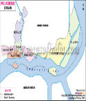
The territory of this former French Colony has four administrative districts of Puducherry, Karaikal, Mahe, and Yanam. All the district towns are located in coastal areas and are enclaves embedded in the surrounding states. Karaikal district lies in the south of Puducherry on the East coast within the state of Tamil Nadu. Whereas Mahe, the smallest district town, is located on the Western Ghats. It lies in the Malabar Coast in Kerala, 603 kilometers away from Puducherry. Yanam district lies on the coast of Andhra Pradesh, 807 kilometers from Puducherry.
Puducherry, the capital city, is located on the east coast. The other towns are Bahoor, Thirukanoor, Nettapakam, Koodapakkam, Pudukuppam, Sedarapet, Abhishegapakkam, Mudallarpet, Kirumampakkam, and Embalam.
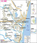
Roads and Rail Line in Puducherry Pocket
The district has an extensive road network with main towns connected with metalled roads. Two highways National Highway 32 runs in the state of Tamil Nadu and connects Puducherry city. National Highway 332 starts from Puducherry city and links it to Villupuram.
Southern railways connect the Puducherry district. A broad gauge rail line connects Puducherry city to Villupuram in Tamil Nadu. Villupuram is a major rail junction in Tamil Nadu.
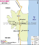
Tourist attractions in Puducherry
Given its French charm and beautiful beaches, Puducherry is very popular among domestic and international tourists alike. Another huge draw to Puducherry is the Aurobindo Ashram, where Sri Aurobindo spent his last years. The experimental city of Auroville, located on the outskirts of Puducherry, which attracts people from all corners of the world. Other than that, there are many attractions which are popular among tourists such as Mahe riverside, Karaikal church, Immaculate Conception Cathedral, and so on.
Puducherry State Information | |
|---|---|
| Capital | city of Puducherry |
| Date of formation | '1 November 1954 |
| Lt. Governor | Kiran Bedi |
| Chief Minister | V. Narayanasamy |
| Tourist attractions | Serenity Beach, Plage Paradiso beach, Karaikal Beach, Place du Government, Aurobindo Ashram, Auroville, Mahe riverside, Karaikal church, Immaculate Conception Cathedral |
| Festivals | Fire-Walk Festival, Sedal Festival, Mascarade Festival |
| Languages | Tamil, Telugu, Malayalam, English and French |
| Size | 483 km2 (186 sq mi) |
| Population (Census 2011) | 1394467 |
| Major crops | Paddy, pulses, coconuts, Areca nut, spices |
| Factoids | Mahe is also known as Mayyazhi or the 'sea's eyebrow'. |
| The ancient town of Arikamedu traded pottery, beads, precious stones and textiles with the Romans in exchange for wine, olive oil and fish sauce. | |
| No. of District | 4 |
Last Updated on : April 17, 2026
Union Territories of India
About Puducherry
Puducherry Transport & Infrastructure
Puducherry Travel & Hotel Information