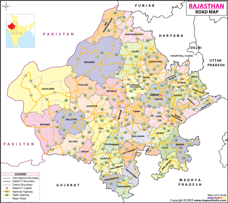
A number of national highways join Rajasthan to the other parts of India. A Rajasthan road map shows all the important highways (national and state) in the state. The most famous highway in the state is National Highway 8. It is the oldest highway with 4-8 lanes in the country.
The state houses one inter-city surface transport infrastructure comprising bus services and railways. All the major cities in the state are joined by railways, flights, and roadways.
Roadways
Rajasthan is sufficiently linked with all the major cities in India like Ahmedabad, New Delhi, and Indore through both National and State Highways.
The RSRTC or Rajasthan State Road Transport Corporation, which is a state-owned organization, offers regular bus services to different parts of the state. Privately owned operators also run bus services.
The national highways system in Rajasthan encompasses an overall span of 5,585 km. The NH8, the most well-known highway in the state, joins major cities such as Ajmer, Jaipur, Udaipur, and Chittorgarh. The length of the NH 8 is around 688 km inside the borders of the state.
The names of the other national highways in the state are as follows: NH 11, NH 3, NH 11B, NH 11A, NH 14, NH 12, NH 65, NH 15, NH 79, NH 76, NH 89, NH 79A, NH 112, NH 90, NH 113, NH 116, and NH 114.
At present, the number of state highways in the state is 85 and the combined span of these thoroughfares is 11,716 km.
The state highways and national highways in Rajasthan represent 14.5% of the transportation system. At the same time, these highways handle 85% of the traffic movement. Bitumen roads join approximately 60% of the villages in Rajasthan.
The state is well joined with a roadways network spanning 150,876 km that runs across the state.
Given below are the names of the national highways in Rajasthan:
- NH3 - The distance between the border of Madhya Pradesh and the border of Uttar Pradesh - Majiyan is 20 miles or 32 km
- NH8 - Starting from the border of Gujarat - Bechiwara - Khairwara -Udaipur - Nathdwara - Dewair - Bhim - Beawar - Ajmer - Kishangarh - Jaipur - Manoharpur - Kotputli - Behror - Ajarka till the border of Haryana (covers a distance of 688 km or 428 miles)
- NH11 starting from Bikaner on National Highway 15 - Sri Dungarh - Ratangarh - Fatehpur - Sikar - Ringas - Jaipur - Dausa - Mahwa - Bharatpur till the border of Uttar Pradesh (covering a distance of 330 miles or 531 km)
- NH11A - Starting from Kothum on National Highway 8 connecting Lalsot, Dausa and Manoharpur (covers a distance of 90 miles or 145 km)
- NH11B - Starting from Dhaulpur on NH 3 - Bari -Barauli - Anjai - Muthra - Sir - Karauli - Gangapur and ending at its meeting point with NH 11A close to Lalsot (covers a distance of 110 miles or 180 km)
- NH12 - From Jaipur - Kothum - Tonk - Devli - Bundi - Kota - Jhalawar - Aklera - Ghatoli till the border of Madhya Pradesh (covering a distance of 250 miles or 400 km)
- NH14 - Starting from border of Gujarat - Mawal - Beawar - Abu Road - Pindwara - Sirohi - Sanderav - Pali - Chadawal (covering a distance of 190 miles or 310 km)
- NH15 - Starting from the border of Gujarat - Sanchor - Barmer - Shiv - Devikot - Jaisalmer - Pokaran - Phalodi - Kolayat - Bikaner - Lunkaransar - Suratgarh - Ganganagar and ending at the border of Punjab (covering a distance of 563 miles or 906 km)
- NH65 - Starting from Pali - Jodhpur - Soila - Nagaur - Deh - Ladnun - Salasar - Fatehpur - Churu - Rajgarh and ending at the border of Haryana (covering a distance of 252 miles or 405 km)
- NH71B - Starting near the border of Haryana close to Taoru and ending at Bhiwadi which is also close to the border of Haryana (covering a distance of 3.1 miles or 5 km)
- NH76 - Starting from the border of Madhya Pradesh - Deori - Shahbad - Kishanganj - Baran - Kota - Kheri - Pindwara - Chittaurgarh - Udaipur and ending at Gogunda (covering a distance of 300 miles or 480 km)
- NH79 - Starting from the border of Madhya Pradesh - Nimbahera - Chittaurgarh - Jharwasa - Nasirabad - Ajmer (covering a distance of 140 miles or 220 km)
- NH79A - Nasirabad (National Highway 79) - Kishangarh (National Highway 8) (covering a distance of 22 miles or 35 km)
- NH89 - Bikaner - Nokha - Nagaur - Ren - Pushkar - Ajmer (covering a distance of 190 miles or 300 km)
- NH90 Aklera - Baran (covering a distance of 62 miles or 100 km)
- NH112 - Barmer Kawas - Tilwara - Balotra -Pachpadra - Kalyanpur - Jodhpur - Kaparda - Bilara - Jaitaran - Bar - and ending at the highway's meeting point with NH 14 close to Bar (covering a distance of 213 miles or 343 km)
- NH113 - Starting from the border of Gujarat to Banswara - Bari - Sohagpura - Pratapgarh and ending at its meeting point with National Highway 79 close to Nimbahera (covering a distance of 120 miles or 200 km)
- NH114 - Starting from near Pokaran on National Highway 15 to Dechhu - Shaitrawa - Balesar and ending at the highway's meeting point with National Highway 65 close to Jodhpur (covering a distance of 110 miles or 180 km)
- NH116 - Starting from Sawai Madhopur and ending at the highway's meeting point with National Highway 12 close to Tonk - r - Uniara (covering a distance of 50 miles or 80 km).
Last Updated on : February 19, 2026
Places to Visit in Rajasthan


