

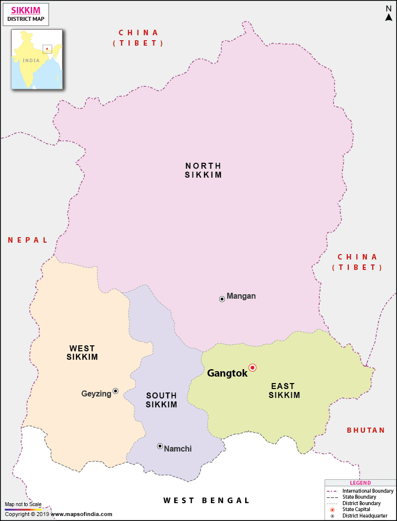




In recent years, changes have been introduced at the administrative level of Sikkim. Previously, Sikkim was divided into four districts, namely East Sikkim, West Sikkim, North Sikkim and South Sikkim. The names were changed to Gangtok, Gyalshing, Mangan and Namchi, respectively, and Pakyong and Soreng were established as new districts. Currently, the state of Sikkim consists of 6 districts – Gangtok, Mangan, Namchi, Gyalshing, Pakyong and Soreng.
Districts of Sikkim
The Sikkim district map helps users understand the location and administrative spread of all six districts. Each district has its own headquarters and distinctive geographical and cultural characteristics.
Gangtok District
Gangtok District, being part of the former East Sikkim, has the capital of Sikkim, Gangtok, which is also a significant administrative and commercial hub. The district is one of the most highly populated areas of the state and is a tourist hotspot. The district has several popular tourist spots such as Tsomgo Lake, Nathula Pass and Rumtek Monastery. The district is also significant for transportation and connectivity to other parts of Sikkim. The mountain setting is a mix of urban settlements, forests, valleys and agricultural land.
Mangan District
The old name of Mangan District was North Sikkim. It is the largest district of Sikkim by geographical area, with rugged Himalayan topography, high-altitude valleys, glaciers, alpine topography, etc. Mangan is the district headquarters. There are a number of reputed places in the district like Chungthang, Lachung and Yumthang. It is rather important for mountain tourism, biodiversity and adventure activities due to its natural environment. The district's topography also can alter the accessibility from one season to the next.
Namchi District
The District of Namchi is located in the south of the State, earlier known as South Sikkim District. Namchi is its headquarters and has developed into an important tourism centre. The district is famous for its beautiful environment, farming activities, tea gardens and religious sites. The scenery features hills and valleys, with some settlements visible along the winding mountain roads. Namchi and places around here are also popular tourist locations, with agriculture and tourism being significant parts of the regional economy.
Gyalshing District
Previously, West Sikkim was called as Gyalshing District. Gyalshing is the district headquarters. The district's cultural heritage, monasteries, mountain scenery, and trekking routes are the main attractions.
Pelling, Pemayangtse, Yuksom and the Ruins of Rabdentse are of interest. The district is endowed with forests, mountains and historical sites that are a great attraction for nature and heritage tourism.
Pakyong District
Pakyong is one of the newer districts of Sikkim and was a part of the erstwhile East Sikkim district. It is headquartered in Pakyong. The district comprises agricultural areas like Rhenock and Pakyong, settlements, and mountainous areas.
The eastern location of the district has significance with regard to connectivity, administration and the broader context of regional development. Pakyong is also linked to the state's growing transportation network.
Soreng District
Soreng is another new district formed from the erstwhile West Sikkim district with Soreng as its headquarters. It covers Daramdin, Kaluk, Mangalbarey and Soreng areas.
The district is famous for its green hills, green agricultural land and rural settlements. It is a place of scenic beauty and is close to other places of interest in the western section of Sikkim, which has the potential for tourism and economic development.
Importance of the Sikkim District Map
The Sikkim District Map can be beneficial in learning the administrative geography of Sikkim. The map is helpful for Sikkim as the geographical landscape is highly mountainous in nature, thereby making it easier to determine the relative position of districts, headquarters, roads and important towns. The map is particularly useful for:
- Identifying all six districts of Sikkim
- Locating district headquarters
- Understanding the administrative division of the state
- Planning travel between different parts of Sikkim
- Studying the state's geography and regional development
- Locating major towns and tourist destinations
- Understanding the relationship between districts and the surrounding Himalayan region
Sikkim District Map and Tourism
The geographical and tourism potential of the districts of Sikkim vary widely. Gangtok is famous for urban tourism, monasteries and eastern Himalayan destinations. Mangan is known for its alpine scenery, and destinations like Yumthang and Gyalshing are known for Pelling, Yuksom and historic Buddhist sites. Namchi is a place of scenic beauty and religious and cultural interest. There are chances to explore less urbanized parts of the state at Pakyong and Soreng. The district-wise approach is, therefore, useful in administration as well as to understand the distribution of natural, cultural and tourism resources in Sikkim.
Conclusion
Sikkim District Map not only provides an easy understanding of the administrative geography of the state but also allows you to explore different maps of the state. The present district structure of Sikkim (six districts—Gangtok, Mangan, Namchi, Gyalshing, Pakyong and Soreng) is the outcome of administrative reorganization of Sikkim. The district-wise map gives the location of the districts, headquarters, major towns and the nature of the region for students, researchers, travellers and students studying geography of Sikkim. The district map is also clickable to explore each district and provide a more detailed understanding of the diverse Himalayan landscape of Sikkim.
FAQs
Q1: How many districts are there in Sikkim?
Sikkim has six districts: Gangtok, Gyalshing, Mangan, Namchi, Pakyong and Soreng. The Sikkim district map shows their locations and boundaries.
Q2: What are the names of the districts in Sikkim?
The six districts of Sikkim are Gangtok, Gyalshing, Mangan, Namchi, Pakyong and Soreng.
Q3: Which is the largest district in Sikkim?
Mangan is the largest district in Sikkim by area. It covers much of the northern part of the state and features high Himalayan mountains and valleys.
Q4: Which district is the capital of Sikkim?
Gangtok District is the capital district of Sikkim, with Gangtok as its headquarters and the state's administrative centre.
Q5: Which are the newly created districts of Sikkim?
Pakyong and Soreng are the two newer districts of Sikkim. They were created during the state's administrative reorganization.
Q6: What are the headquarters of Sikkim's districts?
The headquarters are Gangtok, Gyalshing, Mangan, Namchi, Pakyong and Soreng, corresponding to their respective districts.
Last Updated on: August 21, 2026
