
Introduction
Bageshwar district is a large administrative and cultural unit found in the Kumaon division of the Indian state of Uttarakhand. Since its creation as a separate district in 1997 by subdivision of Almora district, it has progressively grown to be a significant governance, spiritual and regional centre of the central Himalayan belt. It has its headquarters at the town of Bageshwar, where the Saryu and Gomti meet, and has given it religious and even geographical significance throughout centuries.
The area is also well known in terms of its picturesque natural beauty with its forested mountains, river gullies and snowy mountains which are part of the bigger Himalayan ecosystem. It also has a topography that is scenic and rugged and receives the pilgrims and nature lovers. Mythology is also firmly enshrouded on the land, though the myths attribute it to Lord Shiva, and Baghnath Temple is a centre of worship.
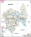
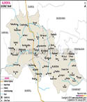
The district contributes much in the socio-economic set up in Uttarakhand especially farming, small-scale industries and tourism. Although it is of rather limited size, the cultural and ecological value of this region is enormous, and it becomes an indispensable town of the Kumaon region. The Bageshwar district map also shows the accessibility of isolated villages to the administrative centres illustrating the challenge and opportunities of administration in a mountainous area.
History
History Bageshwar district has a very close connection with the general historical course of the Kumaon region. The region during the old days was referred to as Danpur and governed by Katyuri dynasty which existed between the 7 th century and 13 th century. Katyuris left strong political and cultural backgrounds in the form of temples and architectural structures that serve as evidence of the ruling Katyuris.
When the Katyuri kingdom fell, the area was overtaken by the Baijnath Katyurs who were immediate successors of the previous kings. In the 16 th century, Chand dynasty gained its influence in Kumaon and in 1565, King Balo Kalyan Chand incorporated the Danpur into his kingdom. It was a time of serious administrative and cultural unity in the region.
In the late 18 th century, the Gorkhas of Nepal invaded Kumaon and governed the territory close to 24 years. Their reign was brought to an end in the Anglo-Nepalese War where the British East India Company overpowered the Gorkhas in 1814. British rule established in 1816 over Kumaon with Bageshwar as part of it, was formalised in the Treaty of Sugauli in the year 1816.
The region joined the United Provinces under the British rule as part of Almora district. With time, Bageshwar emerged as a local administration centre and was proclaimed a tehsil administration in 1974 and later in 1976 it became a pargana. The pressure to have a distinct district had been rising in the late 20 th century and finally the official creation of the Bageshwar district took place in September 1997.
The Bageshwar district map offers a historical insight into the evolution of the territory of the area in terms of the development of smaller entities within bigger kingdoms and the period when this form of government was transformed into an independent administrative administration. It is also used to determine how different dynasties and colonial structures of governance impacted the territories and settlements.
That is why, the history of Bageshwar district is a wonderful cloth of the dynastic reign and the colonial governance and creation of modern states. The Bageshwar district map is still a very vital resource to be known to decode these changes and their effects to the current district.
Culture
The Bageshwar district culture is representative of the larger Kumaon region culture whose values are hallmarked by strong attachment to nature, spirituality and community life. The main feature of culture expression is religious practices where temples and festivals are a leading part of everyday life. The Baghnath Temple which is dedicated to Lord Shiva is one of the key religious figures in the district that draws pilgrims all the year round.
The festivals in Bageshwar are very colorful and strongly-traditional. One of the most important cultural events in the district is the Uttarayani fair that took place in January every year. It also brings individuals in distant villages to have fun with music, dance, trade and socializing. It is not the religious spirit of the territory only that is reflected in this fair but an equally valuable economic and social meeting point.
There are traditional forms of music and dances (Jhora, Chanchari and Chholiya) which are part and parcel of culture in the district. These arts have been commonly used in festivals and celebrations, as a part of the rich heritage of the Kumaoni people. The Bageshwar district map assists in discovering cultural centres and pilgrimage destinations thus giving a graphic look at what is available in cultural terms within the district.
The Bageshwar local cuisine is simple but healthy as the region has different agricultural activities. The dishes prepared using locally produced grains, pulses and vegetables are typical and old recipes are intergenerational. The other significant aspect of the cultural identity of the district is handicrafts (woollen garments and wooden artefacts).
The distribution of villages and cultural centres is also presented in the Bageshwar district map and shows the way the traditions are maintained both in the isolated and accessible regions. The compact community setup and strong sense of place are some of the factors that help in maintaining the cultural heritage within the district. In general, the culture of the Bageshwar district can be considered a nice combination of spirituality, tradition and the ordinary life, and the Bageshwar district map can be taken as the great help in comprehending the culture geography of the Bageshwar district.
Language
The Bageshwar district language is a very crucial issue of its cultural identity which represents the traditions and history of Kumaon region. Kumaoni is the most commonly spoken language in the district; this language is used as the mother tongue by most of the inhabitants of the district. Census reveals that Kumaoni is the most commonly spoken language in the district with approximately 94 per cent of the entire population speaking this language.
The Hindi is the official administrative language, which is also read and spoken in education, governance and communication. There are also smaller groups of the population that speak other languages like Garhwali, Nepali and Urdu due to the cultural diversity of the district.
The Bageshwar district has a representation of linguistic landscape that is more related to its geography as the geography shows variations in dialects between valleys and patterns among villages. The Bageshwar district map can be used to gain an insight into these lingual differences as it shows the localization of settlements and how isolated or connected they are to each other. Even Kumaoni as such has its own dialects, which depend on geographical characteristics and historical encounters. These dialects are thus adding more linguistic heritage to the district, and are also adding to the cultural diversity. Oral traditions, folk literature and local literature are basically written in Kumaoni, which holds the memory and identity of the people in a collective manner.
Geography
The topography of Bageshwar district can be determined by its place being in the central Himalayas which is mountainous, full of deep valleys and rivers. The district is neighboured by the Chamoli district to the north, Pithoragarh district to the east and Almora district to the south and west.
The area is located on a relatively high elevation that differs considerably, and the valleys is lower whereas the peaks are elevated to great heights. Bageshwar town per se is at a height of approximately 900 to 1,000 metres above the sea level, and in a valley created as a result of a meeting point of the Saryu and Gomti rivers.
The percentage of forests in the district is very large; over half of the whole geographical area is covered. These are dense forests with lots of biodiversity and some species they contain are pine, fir as well as oak. Forests are not only a habitat to the wildlife but they also contribute immensely to the ecological balance and providing a livelihood to the local people.
The weather of the Bageshwar district is generally cool, winters are cool and summers are pleasant. Within the monsoon season, the region experiences high rainfall that is healthy in terms of agricultural activities, but typical of landslides, soil erosions, etc. Farming has been reliant on large-scale terraced farming which has adapted to the hilly nature of the district. Rice, wheat and pulse crops, and horticultural goods are usually cultivated. The Bageshwar district map shows the pattern distribution of the agricultural lands, forest cover and river length which gives an overall picture of the physical structure of the district.
The Bageshwar district map is especially helpful to realize the spatial relations between natural resources and human settlement. It puts into focus the issue of connectivity in hilly areas, and how sustainable development practices are. To sum up, the culture, economy and lifestyle of Bageshwar district are characteristic of the geography of this area. The Bageshwar district map is an invaluable visual aid of topographical analysis of the district with its intricate terrain and topographical features.
| Facts of Bageshwar District | |
|---|---|
| Official Name | Bageshwar District |
| Population | 2,59,898 (As of 2011) |
| Area (km2) | 2,246 |
| Religion | Predominantly Hinduism |
| Language | Hindi, Kumaoni |
FAQs
Q1: What is Bageshwar district known for?
Bageshwar district is known for its religious significance, scenic Himalayan landscapes and the Baghnath Temple.
Q2: When was Bageshwar district established?
Bageshwar district was established in 1997 after being carved out of Almora district.
Q3: Which rivers meet in Bageshwar?
The Saryu and Gomti rivers meet at Bageshwar town.
Q3: Which rivers meet in Bageshwar?
The Saryu and Gomti rivers meet at Bageshwar town.
Q4: What is the main festival of Bageshwar district?
The Uttarayani fair is one of the most important and widely celebrated festivals in the district.
Last Updated on : May 08, 2026
| Buy this Map |