
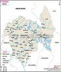
Introduction
The Tehri Garhwal district is not only one of the most geographically and historically important in the Indian state of Uttarakhand, located in the Garhwal division of the central Himalayas, but also forms the part of central Himalayas. Garhwal is called the land of forts (garh) in reference to the historical defensive accommodation of the region and hill forts.
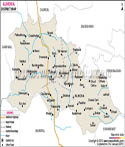
Tehri Garhwal is strategically located and intermingled by districts like Uttarkashi, Dehradun, Pauri Garhwal and Rudraprayag. The topography of the area is also diverse as the district is a special geographical feature, which is usually learned with the help of Garhwal district map to comprehend the elevation gradient, river basins, and the settlement structure.
The headquarters of the district is at New Tehri which is a planned town developed following the submergence of Old Tehri. The area is of enormous significance not just in regard to its natural beauty but also as far as, hydro electric power generation, pilgrimage routes, and heritage. Still, regardless of the analysis using a map of Garhwal district or direct experience, Tehri Garhwal can be discussed as a place of the synthesis of tradition and modern development in the belt of the Himalayas.
History & Culture
The Tehri Garhwal owes much of its history to the history of Garhwal Kingdom that was founded in the medieval times and included rulers like Ajay Pal. The locality was an accredited princely state that was referred to as the Kingdom of Tehri Garhwal until the year 1949 when it became a part of the Indian Union. It operated as a semi autonomous monarchy under the British control before gaining independence. The patterns of forts and settlements in mountainous countries have frequently been noted in terms of the strategic positioning of these sites within historical texts and interpretations on the basis of the Garhwal district map.
The Tehri Dam became one of the most characteristic historical changes that happened in the late twentieth century. Old Tehri town was submerged and thousands of people were resettled due to this project. Although the inner story is controversial, it also changed the modern history and development course of the district. The geography and lifestyle of this region have been changed significantly as demonstrated by the Garhwal district map today showing the huge reservoir that has been formed through the dam.
Tehri Garhwal is a cultural hub of Garhwali customs. Mainly the local community is Hindu and the district is scattered with the old temples of god like Shiva and Durga. Celebrations such as Makar Sankranti, Basant Panchami and Harela are taken with a festive spirit as the community is agrarian in character. Pandav Nritya and folk music are just some forms of folk dances that are incorporated in local celebrations.
Garhwali language is commonly spoken, along with Hindi, and it is a vehicle of oral traditions and folklore, as well as songs. The culture tends to follow the routine of seasons and as such, these can be traced geographically with the Garhwal district map, which helps in showing how the landscape shapes the way of life. The district is also characterized by handicrafts, woolen clothes and rural cuisine. The failure to lose traditional practices in favor of assimilating modernity serves as an important indicator of cultural strength of Tehri Garhwal.
Economy
The Tehri Garhwal economy is varied and is mostly influenced by its mountainous nature. The economic structure of the district may be perceived based on its government, its public and services area which is affected by the accessibility and the terrain as in the Garhwal district map.
Administrative services, education, and the public welfare programmes become important in the government sector in terms of employment creation. Government projects are typically oriented towards rural development, accessibility of roads, or disaster management as the region is a hilly district. New Tehri is one of the administrative centres and can be identified on the Garhwal district map quite easily.
The hydroelectric generation is the main power in the public sector and Tehri Dam is one of the largest ones in India. The project has a higher impact on the energy supply in the state and offers jobs in the sphere of engineering, maintenance, and other fields. The Garhwal district map clearly shows this change due to the reservoir and other related infrastructure that has changed the economic outlook of the district.
The economy has a traditional underpinning of agriculture, but it is mostly based on subsistence because of low arable land. There is general production of crops, like millets, wheat and pulses and horticulture, like fruits, such as apples and apricots, is also becoming important. Terrace cropping is a unique characteristic, which has been adapted to mountains. Such farming trends are interpretable on the basis of heights zones that have been illustrated on the Garhwal district map.
The service industry especially tourism is soaring. Many residents depend on hospitality, transport, and local trade as a source of livelihood. The adventure tourism and pilgrimage activities like trekking and camping ensure that more people visit the country hence increasing revenue. The Garhwal district map is usually used as a roadmap to plan out the routes and discover the tourist circuits. In general, Tehri Garhwal economy is a compromise of traditional culture and modern development projects.
Tourism
Tehri Garhwal is a leading tourism attraction site in Uttarakhand, which is a combination of natural attractions, spiritual worship, and adventure experience. The mountainous terrain of the Garhwal district has its attractions scattered, which makes the Garhwal district map one of the indispensable maps of the region to the travellers.
The most striking sight is the Tehri Lake which is created as a result of the Tehri Dam reservoir. It has been developed into a water sporting destination which includes boating, jet skiing and kayaking. With the picturesque environment and serene waters it is a favorite tourist spot amongst the local and international ones. Its location and reachability is well noted in the Garhwal district map and this helps the visitors in making plans.
The other important location is Chamba which is a beautiful hill station with a panoramic view of the Himalayas. It is the main access point to various tourist destinations and it is also accessible through road. The map of the Garhwal district will assist in determining the location of Chamba in terms of other destinations.
There are also religious temples like Surkanda Devi Temple in the district that is situated on a high altitude and provides spectacular views. It is a spiritual experience and also an adventure as pilgrims go on an expedition to visit the temple. Equally, another holy spot is Kunjapuri Temple, which also draws both devotees and other people who visit the area. The Garhwal district map tends to map these temples as important religious places.
To nature lovers, such destinations as Dhanaulti provide a heavy forest, eco-parks and serene environment. There are many trekking trails, camping places where one can also venture out to find out the Himalayan terrain. Garhwal district map would come in handy especially in the navigation of these trails and the topography of the area.
Generally, Tehri Garhwal is a destined area that is diversified in terms of tourism denoting both spiritual trips as well as adventure sporting activities. The natural and cultural diversity of the district guarantees a rich experience to be enjoyed by visitors and the map of the Garhwal district is an inseparable complement in the exploration.
Demographics
The population of Tehri Garhwal district is about 618,931 according to census of India 2011. The population is spread in the rural and semi-urban states, where there is a large amount of people living in the villages located on mountainous land. The Garhwal district map also gives an understanding of the population distribution with the settlements being affected by geography.
The district literacy rate is also about 75.1, which indicates a stable development in education despite the geographical factors. Learning institutions are centralized in convenient zones, as can be determined on the Garhwal district map. The government has made efforts that have enhanced literacy over the years.
The dialects spoken in the district are Garhwali and Hindi, where Garhwali is the main local language that is spoken and used in the day-to-day activities. The cultural zone tend to follow the tongue patterns and this can be explained by the Garhwal district map.
The demographic portrait of Tehri Garhwal reveals the existence of a community, which is very close to its surrounding and customs, but changes gradually under the impact of modernity.
Administration
Tehri Garhwal district is an administrative district subdivided into various tehsils in order to have good governance. These are Tehri, Devprayag, Narendra Nagar, Ghansali, Pratapnagar and Jakhnidhar. The tehsils are also a local administrative unit where they take responsibilities in revenue collection, law and order, and development work. Borders and the situation of these tehsils are also well exemplified in the map of Garhwal district.
The district has over 1,800 villages including most of them in remote locations and hilly regions. These are villages which are the main prosperous rural centers of the district economy and culture. Villages are not always easily connected with each other because of terrain, and this aspect can be clearly seen when Gawhwal district in the map is considered.
Local governance is conducted by use of Panchayati Raj institutions that are very important in carrying out the development programmes at the grassroots level. Even administrative planning and resource allocation is often based on information obtained using the Garhwal district map, which means that even isolated parts are taken into consideration. In general, the Tehri Garhwal administrative system is arranged in such a way to fit in the peculiarities of its location and to encourage the development and governing.
FAQs
Q1: What is the total number of villages in Tehri Garhwal district?
The total number of villages in Tehri Garhwal district is over 1,800.
Q2: What is the population of Tehri Garhwal district?
The population of Tehri Garhwal district is approximately 618,931 as per the 2011 Census.
Q3: What is Tehri Garhwal district famous for?
Tehri Garhwal district is famous for the Tehri Dam, scenic Himalayan landscapes, and its rich Garhwali culture.
Last Updated on :May 08, 2026
| Buy this Map |