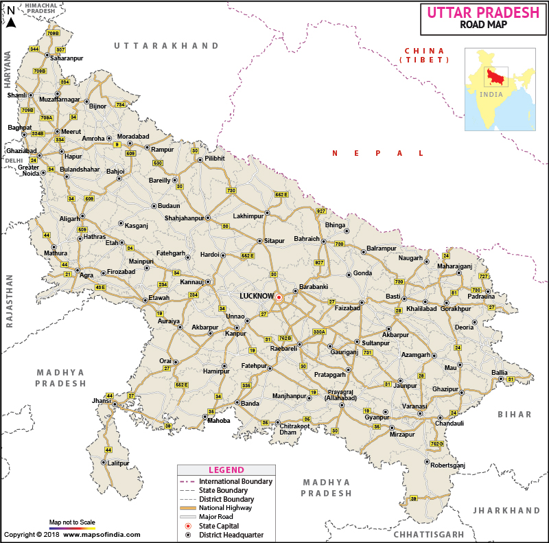
Uttar Pradesh Road Network
National highways and State highways in Uttar Pradesh
Uttar Pradesh was also called Northern Provinces during British era. It is the most populous state and one of the largest state-economies in India. Uttar Pradesh also has one of the largest road networks in the country, second only to Maharashtra.
Around 42 National Highways and 83 state highways form a large network of roads to ensure that every town and most of the villages are interconnected. This is essential to ensure smooth transportation and logistics operations in this densely populated commercial state.
National Highways in Uttar Pradesh
The longest national highway that passes through Uttar Pradesh is NH2 and it stretches up to a length of 752km in the state. This highway starts from Kosi, which is situated on Haryana border and passes through Mathura. Mathura is famous for Vrindavan, the abode of Lord Krishna, the mythical Indian deity.
After that, it goes to famous tourist destination in Agra. The Agra Fort and the Taj Mahal are the centre of attractions in Agra. Then the highway further stretches to Etawah and goes to commercial town Kanpur. From Kanpur it goes to Allahabad and Varanasi, the ancient cities. The last destination of this highway in Uttar Pradesh is Chandauli; the town is located on UP Bihar border.
NH24 is starts from Ghaziabad, near Delhi border. It goes through Hapur and Moradabad, the city famous for brass handicrafts. It further goes to Rampur and Bareilly and reaches capital Lucknow, the city of Nawabs. The total length of this road is 431 km.
National Highway 76 starts from Madhya Pradesh border. Jhansi is the origin of this highway in Uttar Pradesh; it takes you to Mauranipur tehsil on MP border. From there it goes to Banda and Mau and ends in Allahabad. The total length of this highway is 500 km, approximately.
NH91 also begins from Ghaziabad and goes through Dadri and Bulandshahr towns. It also passes through the industrial town Khurja, Aligarh and Kannauj in UP. This road terminates in Kanpur. The length of National Highway 91 is around 400 km.
NH93 is another important National Highway in Uttar Pradesh. It commences from the historic city of Agra and cruises through Hathras, Aligarh and Chandausi, before terminating in Moradabad. NH93 is 220km long. The combined length of the National Highways in Uttar Pradesh is around 5,900 km.
State Highways in Uttar Pradesh
State Highway1 lies in Eastern Uttar Pradesh; it passes through four towns Maharajganj, Gorakhpur, Dewaria and Balia, traversing a distance of 154km. UP SH1A also starts from Maharajganj and the route of SH1A is through Farenda- Naugarh- Basti- Shrivasti Marg and it covers Sidharthanagar, Balrampur and Gonda districts. The total length of this road is 230km.
UP SH5 is also a major state highway with a length of around 350km; it starts from Sidharthanagar and goes through Basti, Jaunpur, Mirzapur and ends up in Sonbhadra.
Some other important state highways are SH13 and SH21. They are 228km and 385km respectively.
SH33 is known as Bareilly-Meerut Road. It passes through Badaun, Soron, Kasganj and Sikandra Rao. Badaun is a junction of three State Highways and they are SH33, SH29 and SH51. State highways in Uttar Pradesh cover a total distance of 8,432km.
Last Updated on : January 14, 2026
