Orissa, a state of Oriya speakers, was established as a province of British India on 1 April 1936. The English name Orissa was changed to Odisha on 4 November 2011. Odisha’s history is at least 5,000 years old.
The Kalinga War of the 3rd century BC, which made emperor Ashoka embrace non-violence and adopt the teachings of Buddha, was fought in Odisha. In subsequent centuries, the area was ruled by various monarchs and came under great dynasties such as Harsha’s. Towards the end of the 8th century, the areas comprising Kosala and Utkala were united into one empire by Jajati Kesari I.
The remarkable Sun Temple at Konark was built by King Narasimha Dev.
In the 16th century Odisha came under the rule of the Sultanate of Bengal. In 1576 the Mughals got hold of coastal Odisha. Some other parts were ruled by smaller Hindu kingdoms. In the mid-18th century, the Marathas took control of parts of coastal Odisha.
After the Carnatic Wars the British East India Company merged the southern coast of Odisha with the Madras Presidency.
From the Raj to Swaraj
British misrule brought misfortune to the state of Orissa in the 19th century. At the same time, however, there was a growth in both linguistic consciousness and national sentiment among Oriya-speaking people.
As Paresh Sahoo wrote in the Orissa Review in April 2006: “The local newspapers like the Utkal Dipika of Cuttack, Prajabandhu of Rambha, and the Sambalpur Hitaisini of Bamara played an important role . . . [in creating] national consciousness among the Oriyas under the towering personalities of [people like] Shyamasundar Rajguru of Paralakhemundi, Nilamani Vidyaratna of Bamara, [and] Gaurisankar Roy of Cuttack.”
In 1912 the coastal section of Bengal was made into the separate provinces of Bihar and Orissa.
A commission appointed by the central government, consisting of C.H. Phillip and A.C. Duff, visited places like Vizagpattam, Mandasa, Chikiti and Rambha in 1924 to get a first-hand view of the people’s opinion. It concluded: “There is a genuine and long standing deep-seated desire on the part of the educated Oriya classes of the Oriya speaking tracts to amalgamate with Orissa under one administration.”
Finally, in 1936, Odisha got its current identity when the Oriya-speaking people got their own province. The addition of two dozen princely states after Independence nearly doubled the area of this state in independent India.
Facts and Figures
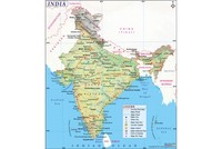
With a population of 41 million (2011 Census), Odisha is the 11th most populated state in the country, with a share of about 3.5% of India’s population. Its area of 155,820 sq km makes it the 9th largest state.
The literacy rate of the state (73.45%) is nearly equal to the national average, but there is a huge gap between male (82%) and female (64%) literacy. The state’s sex ratio of 978 and child sex-ratio (934) are higher than the corresponding national figures.
However, Odisha’s poverty headcount ratio (57.2%) is at the bottom of the list of Indian states, according to the 2009 Tendulkar Committee Report.
Oriya, the official language, is spoken by over four-fifths of the population. Scheduled Castes and Scheduled Tribes together constitute 38.7% of the state’s population.
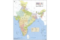
Orissa has 30 districts. Other than the capital Bhubaneswar, the important cities include Cuttack, Rourkela and Brahmapur.
Places of interest
Odisha has a lot to offer every kind of traveller.
Bhubaneswar, the seat of Lord Tribhubaneswar, is both a Hindu pilgrimage centre and a modern city. One can still find hundreds of temples in the old quarters.
Chilka, one of Asia’s largest brackish water lakes, spread over an area of 1,100 sq km, is great for fishing, boating and bird-watching. Thousands of migratory birds come here in the winter months.
One of India’s architectural landmarks, the Sun Temple at Konark, is a superb example of Orissa’s temple architecture. In the words of poet Rabindranath Tagore, “Here the language of stone surpasses the language of man.”
The magnificent 12th-century Lord Jagannath Temple at Puri attracts visitors from all over the world.
These form only a tiny sample of the tourist attractions in the state. The long coastline and forests make it possible to take a much less-travelled path as well.
Also on this day:
1889 — K.B. Hedgewar, founder of the Rashtriya Swayamsevak Sangh, was born
1911 — Fauja Singh, British centenarian marathon runner of Sikh descent, was born
1936 — Tarun Gogoi, Chief Minister of Assam, was born
1937 — Mohammad Ansari, Vice President of India, was born
1984 — Murali Vijay Krishna, Indian cricketer, was born
References:
- Wikipedia