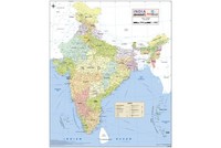
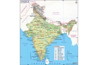
On 31st August 1956 the President of India gave his assent to the States Reorganisation Bill, which is now known as the States Reorganisation Act.
The States Reorganisation Act essentially sought to define the boundaries of Indian states and territories and organize them based on linguistic lines. Even though many changes have been made to the boundaries of Indian states since 1956, the States Reorganisation Act remains one of the most important changes in state boundaries since 1947. This act came into being at the same time as the Constitution (Seventh Amendment) Act 1956.
Before Independence in 1947, the British Indian Empire (which includes present day Bangladesh and Pakistan) was divided into the Provinces of British India (directly governed by the British officers) and the princely states (ruled by local leaders).
After Independence in 1947, British India was divided into the separate dominions of India and Pakistan. Following this the princely states were asked to join either India or Pakistan (though they were never compelled to do so). Most of the princely states joined India, while a few chose to become part of Pakistan. Between 1947 and 1950, the princely states were politically merged into the Indian Union, either into existing provinces or organized into new provinces.
On 26th January 1950, the constitution of India came into force, making India a sovereign democratic republic. The new republic also was to be a “Union of States” and the Constitution defined the three kinds of states.
Part A States: Former governors’ provinces of British India, which were ruled by an elected governor and state legislature.
Part B States: Former princely states ruled by a Rajpramukh.
Part C States: Included both the former chief commissioners’ provinces and a few princely states.
Part D States: The Andaman and Nicobar Islands was the only Part D state which was administered by a lieutenant governor.
In the years which followed Independence, political movements supporting the creation of new states began to develop and strengthen. One of the earliest movements in this regard was that to create a Telegu speaking state out of the northern part of what was then the Madras State. In 1953, 16 Telegu speaking districts of Madras state became the new state of Andhra Pradesh. Small changes to state boundaries were being made during 1950-1956. Bilaspur, a small state was merged with Himachal Pradesh on 1st July 1954 and former enclave of French India, Chandernagore became a part of West Bengal in 1955.
Following the creation of Andhra Pradesh for Telugu speaking people, gradually others started demanding separate states as well and the Government of India was under increasing pressure to allot separate states for people speaking different languages. Gujarati, Marathi and Punjabi speakers were all demanding separate states for themselves. The challenge was that India is a nation with numerous languages and dialects. Finally it was decided that the development of a state was largely dependent on the development of the regional language.
Even though many critics described this linguistic separation as a “division”, leaders like Gandhi (who championed the cause of linguistic division of states) was of the opinion that education, along with the true essence of democracy could only be explained to simple village dwellers in their regional language, which is why linguistic separation of states looked like a good idea. The Education Commission, created by the Government of India also believed that providing education to students was easier if done in their mother tongue. And since language was the basis tool through which two people communicated with each other and eventually clear communication leads to exchange of ideas and ultimately development, the decision to go ahead with linguistic division of states was made.
In December 1953, the then Prime Minister Jawaharlal Nehru appointed a States Reorganisation Committee, which was headed by Justice Fazal Ali and was known as the Fazal Ali Commission. The work done by this commission was supervised by Giving Ballabh Pant, who served as Home Minister from December 1954. In 1955, the commission drafted a report recommending the reorganization of Indian states.
On 31st August 1956 the States Reorganisation Act came into force and came into effect on 1st November of the same year. Though, before that a crucial amendment to the Constitution of India also came into force. Under this new amendment, the existing distinction among Part A, Part B, Part C and Part D states were done away with and they came to be known as the “states”, while the Part C and Part D states were replaced by a new entity of “Union Territory”.
Also on This Day:
1947: Jawaharlal Nehru visits riot-hit Punjab, along with Liaqat Ali and Sardar Patel
1969: Cricketer, Javagal Srinath was born in Mysore.
1995: Beant Singh, Chief Minister of Punjab assassinated in a bomb blast. He is remembered for playing a very important role in quelling militancy in Punjab.