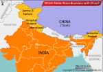
The Geological Survey of India (GSI) is a government organisation which is an office associated with the Ministry of Mines of Union Government of India. Established in Calcutta on 5 March 1851, GSI conducts geological surveys and studies and is one of the oldest of such organisation in the world. GSI is also the second oldest survey in India. Being the prime provider of basic earth science information to the Indian government, industry and the general public, GSI is also the most responsive participant in the international geoscientific fora, coal, steel, metals, power and cement industries.
The phrase “Geological Survey of India” was first used on William’s Map of the Damoodah and Adji Great Coal Field. While the work of Geological Survey was primarily refrained to exploration of coal for powering steam transport, oil reserves and ore deposits, it was in 1852 that Sir Thomas Oldham, father of Richard Dixon Oldham widened the scope of functioning of GSI by advancing the argument with Indian government that it was actually impossible to spot coal without first mapping the geological structure of India. To sum it up, the Geological Survey of India has indeed made excellent contributions to seismology via its meticulous investigations, studies and detailed reporting of earthquakes which shocked India in the 19th and early 20th century.