| Click any district on the map and get the detailed district map. |

|
Goa attained statehood on 30th. May 1987and became the 25th state of the Indian Union.
The state of Goa is divided into two administrative units North Goa, with its headquarters at Panaji and South Goa with its headquarters at Margao.
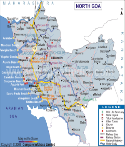
The district of North Goa has an area of around 1736 square kilometers and comprises of 6 talukas.
The district is famous for its beaches, palm trees and paddy fields. South Goa has an area of around 1966 kilometers and comprise of 5 talukas.
It is famous for its natural beaches, waterfalls, hill spots and coconut gardens.
 |
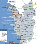 |
| North Goa District Map | South Goa District Map |
List of Districts in Goa
| Sr. No. | District | District HQ | Population (2011) | Growth | Sex Ratio | Literacy | Area (km2) | Density (/km2) |
|---|---|---|---|---|---|---|---|---|
| 1 | North Goa | Panaji | 818008 | 7.84% | 963 | 89.57 | 1736 | 471 |
| 2 | South Goa | Margao | 640537 | 8.73% | 986 | 87.59 | 1966 | 326 |
Last Updated on : August 25, 2014