






About
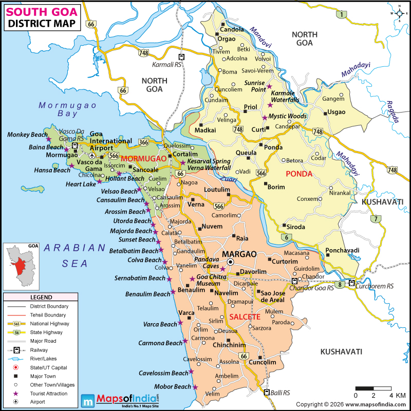
It doesn't matter how the soothing, humid wind blows through these dramatic landscapes of the Western Ghats; an unmistakable, very intoxicating allure emanates from a calm and serene South in India's tiniest state. As one traces the boundaries of the South Goa district map, one immediately observes a tapestry of pristine sun-drenched coastlines, green forests and serpentine rivers, rolling silently towards the sea. The place is a remarkably tranquil sanctuary of slow-paced authenticity and natural splendour, but removed from its wild and tourist-tackled northern equivalent. The administrative division, which covers approximately 1,966 square kilometres, spreads out like a landscape reaching endlessly from the blue Arabian Sea on the west to the summits of the mountains on the east, holding onto valiantly its historic administrative centre, Margao.
But further inland is a lush landscape of long traditional paddy fields and old spice and fruit trees, along the gentle currents of a river. If you examine it closely on a South Goa district map, you will see there is a wonderful balance of rough and smooth mountainous areas, and flat, fertile alluvions. From the old road tracks that weave through the forests to the Riviera routes that lie along the coast, the district welcomes you to an environment of beauty and tranquillity that appears to date back centuries, so that serene cycles of nature blend with centuries of coastal tradition.
History & Culture
These sun-kissed, palm-fringed shores have witnessed, by thunderous ocean swells, silently for tens of thousands of years, people moving around each other doing various things, some of them engaged in trade and others controlling power and imperialistic empires. In ancient times, the local dynasties, such as the Bhojas, Mauryas, Badami Chalukyas and Kadambas, extended their rule over these fertile lands and developed a lush riverine trade that created magnificent stone temples, long before modern cartographers drew the district boundaries of the South Goa district map. The Portuguese conquest of Goa, which took place in December 1510, marked the beginning of more than four hundred years of European colonial power, which transformed the social, architectural and spiritual landscape of the region.
When you carefully study an old South Goa district map, created when South Goa was conquered, you will see the traces of a remnant history of dividing South Goa into Velhas Conquistas (Old Conquests) and Novas Conquistas (New Conquests) very clearly, especially where old chapels are found, where the whitewashed churches are and where a mansion stands. Finally, after a long, complex history of colonial rule, the glorious military takeover of India under the name of Operation Vijay, on 19th December 1961, marked the end of the colonial era and later the full statehood of Goa was attained in 1987. The sense of inter-faith unity that pervades these unobtrusive hamlets is marked by colourful celebrations of Hindu Shigmo blending into joyful festivities of Catholic celebration and the internationally famous Goa Carnival.
The eternal essence of Susegad—the Goan, Coen jhola way of life, with harmony and tranquillity—is prevalent in every tranquil village marked on a South Goa district map, in traditional brass music bands and in folk dances such as Mando and Fugdi and the smoky fragrance of cashew feni made at home. Strolling through the village squares, one is struck by centuries-old tilework, grand arched porticos and sacred courtyards that display a fascinating synthesis of the Western European and traditional Indian sensibilities. These festivals here are not isolated occasions for the public, but are powerful symbols of communal gatherings, with whole neighbourhoods joining to celebrate and enjoy feasts, pray and observe traditional practices that they have inherited from their ancestors.
Economy
It's a beautiful district with swaying coconut palms, but also a strong and complex economy, contributing to the state's well-being and growth. The industries that run along the economic and industrial corridors mapped out on a South Goa district map are organised into an interesting combination of industrial activities, sea trade, agriculture and high value services. In the Government Sector, administrative departments, forestry divisions, as well as municipal councils and public service centres based around the Matanhy Saldanha Administrative Complex in Margao create a vast number of civic employment opportunities, and play a key role in coordinating the development of civil infrastructure; government agencies are then working hard to facilitate compliance with regulations in the environment and to ensure rural connectivity.
Critical installations for the Public Sector have enabled them to maintain their formidable and strategic presence, like the Mormugao Port Authority, which is one of the oldest and premier natural harbours of India and other such important establishments like naval and air force bases. Also, having vast public sector banking networks and national highways. These state-run enterprises ensure maritime transport and maritime trade logistics do not lag behind even during socio-economic crises or disasters, allowing the country's coastal areas to serve as an unbreakable link in global movements of trade goods.
Hospitality, financial, maritime logistics, and retail are the industries that hold core positions for the local economy in the Services Sector, in the field of which the vitality is outstanding. Every year, millions of domestic and international tourists flock to its lovely beaches, supporting high-end resorts, boutique homestays, transport infrastructures, and flourishing eco-tourism enterprises throughout the wild interior. In the meantime, the important manufacturing areas have developed around the large industrial estates at Verna, Nessai and Kakoda, where large-scale pharmaceutical industrial plants, manufacturing units for consumer goods, food processing and light engineering companies are thriving.
The agriculture and fishing sector is still the pillar of traditional livelihoods, along with remarkable rice fields, emerald fields and jungles of cashew orchards, coconut plantations, and spice gardens. In fact, analysing each and every commercial and industrial locality across a South Goa district map showcases a balanced, resilient economy of both the Old and the New, with the focusing and protecting effect of the landmark commerce and tourism ecology, while striving to balance all the dynamism of industrial enterprise with an eco- conscious and sustainable tourism and traditional agrarian practices.
Tourism
Embarking on the call of South Goa is protocol to enter into an ethereal realm of unsouiled marvels, golden beaches and historic attractions. As one follows the scenic roads through the beaches of South Goa, one arrives at the famous stretches such as Palolem beach, famed all over the world for its long arc of sand and peacefully lapping waters that are perfect for swimming.
Any hiker using a South Goa district map can easily navigate Bhagwan Mahaveer Sanctuary in South Goa. Spending nearby time in Netravali Wildlife Sanctuary or Cotigao Wildlife Sanctuary brings a sense of wonder as visitors are enticed by rare plants, exotic birds and invisible natural bubble lakes within the depths of the canopy. For the culture fans, it is easy to wander through the old stone halls of Cabo de Rama Fort on a dizzying cliff, gazing out at the sea's wide expanse.
Referring to a South Goa district map, each landmark offers a unique opportunity to experience the natural environment and the area's history, regardless of whether you are making your own aromatic spice plantation trail or about to soak up the peaceful sun on the tranquil beach. Maritime sightings happen along these untouched sea cliffs, where Sunset escapers line up and watch the red sun as local fishermen bring in the catch of the day.
Demographics
The impact of human geography on this scenic and lovely region of the sea provides hope for high levels of education, strong social cohesion and stable demographic dynamics. The population figures shown on the South Goa district map are obtained from the official Census, which is of 640,537 spread across the district, with a balance of 986 females to 1000 males. Social metrics are remarkable on the national stage, as literacy all over the community is impressive, exceeding 87 per cent. In an overall analysis of the literacy rate, one can see that literacy is remarkable as well and that a progressive attitude has been accepted with great emphasis on learning and human development throughout the community.
More than 60 per cent of the population lives in urban centres such as Margao and Vasco da Gama, while the rest of them enjoy a quiet life in the rural hamlets. In terms of language, Konkani is the rich and valuable primary and state language, and more than two-third of the population speaks it on a regular basis in their daily lives, songs, literature, commerce and in nearly all institutions of modern society, academia, government and business administration.
In terms of demography, all the municipalities and rural communes plotted on a South Goa district map demonstrate peaceful co-existence between the Hindu community and the Christian community, as well as significant Muslim minority communities. This rich mosaic inculcates an abiding sense of respect and togetherness, a local character that permeates the social fabric of everyday life in the district. As one of the most stable and peaceful areas in Western India, lots of families live side by side in their respective neighbourhoods, with good quality of life indicators and low crime rates.
Administration
Public governance is very well-structured in this coastal area, providing effective civic governance, environmental protection and public services to manage both urban and rural areas. The district is divided into seven key administrative subdivisions popularly called tehsils or talukas, namely in Salcete, Mormugao, Ponda, Quepem, Sanguem, Canacona and Dharbandora.
All talukas are administered by a Mamlatdar, who is responsible for local land administration, local public services and also coordinates with the district administration regarding revenue matters. There are 205 revenue villages within these sub-districts, and several census towns and village panchayats are found within each of these sub-districts. Each and every administration from the port town of Mormugao to the southern border of Canacona on a South Goa district is in tandem to act in protecting all public infrastructure and important ecosystems.
The function of the local panchayat is that people attend it to get suggestions for development programs, to obtain the solution of problems related to public sanitation and preservation of the environment and to stop illegal encroachments on forest lands and forests are playing a significant role.
FAQs
Q1: What is the district headquarters?
Margao is the district headquarters.
Q2: What is the total population?
The total population is 640,537.
Q3: How many tehsils exist here?
There are seven tehsils.
Q4: What is the literacy rate?
The literacy rate is 87.59 per cent.
Q5: How many revenue villages exist?
There are 205 revenue villages.
Q6: What is the main official language?
Konkani is the official language.
Q7: What makes the district famous?
It is famous for its beaches and heritage.
Last Updated on : August 04, 2026
