
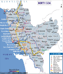
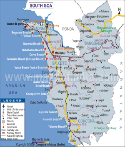
In contrast to the plateaus are the alluvial lowlands of North Goa. These are the in-filled stretches of the rivers which have deposited the eroded material from the Sahyadrian elevation along their banks, on losing their gradient when they emerge from the highlands to meet the sea. The major riverine plains in North Goa are those of Mandovi. Those of Chapora in the North are lesser basins.
A visit to Baga and Calangute is must for your itinerary. These beaches are famous for their extensive curved stretches, white sands and palm fringes. Of the many rivers that drain the land of the district, Tiracol, Mandovi and Sal are the most important. Lakes have a limited and local use for irrigation but constitute a scenic feature in Goa. The important lakes of North Goa are Mayem, Chimbel, Carambolim and Calapur.
The tropical wet forests, of evergreen type with a variety of species, occur in strands in the deeper valleys of the Ghats. Tall trees, dense canopy, sparse middle layer, climbing creepers and dense humus matting are characteristics. They include teak, which occupy most of the forest area. Bamboo and cane are also to be found in other areas. Major mineral deposits in North Goa comprise of iron, manganese, bauxite, limestone and clay. Extracting iron and manganese mining are the major industries of North Goa.
| Quick facts on North Goa |
| Area: | 1736 Sq. Km. |
| Geographical position: | 15o 48' 00" N to 14o 53' 54" N latitudes and 73o E to 75o E longitudes. |
| South boundary: | South Goa District. |
| Other boundaries: | The Sawantwadi & Dodamarg, of Ratnagiri District and Kolhapur District of Maharastra |
| Climate: | Summer: 24 o C-32 o C Winter: 21.3 o C-32.2 o C Rainfall: 320 cm (June to September) |
| Language: | Konkani, Marathi, Hindi, English & Portuguese. |
Last Updated on : May 12, 2026