
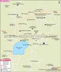
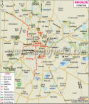
City Map of Mangaluru
Mangalore, an important educational and industrial port city of Karnataka is situated on the west coast, at the confluence of Nethravathi and Gurupura rivers. The city is located at 12° 52 ' N latitude and 74 ° 49' E longitude, bounded in the east by the Western Ghats and bounded in the west by the Arabian sea. Mangalore is in the Dakshin Kannada district of Karnataka, about 326 kilometers from Bengaluru, the capital of the state.
Mangalore city is spread out over an area of 132.45 square kilometers. The two rivers -Nethravathi and Gurupura encircle the city. Nethravathi flows in the south of the city and Gurupura flows in the north of the city. The rivers form an estuary in the south west of the city before flowing into the Arabian Sea. The new Mangalore sea port, India's ninth largest sea port is located north of the city.
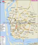
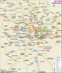
Mangaluru Road Network
The total length of the roads network in the city is 888.9 kilometers. Three national highways pass through the city. NH 17 links Mangalore to Panvel ( in Maharashtra ), Udipi and Kannyikumari (in Kerala). N 48 links Mangalore with Bengaluru. NH 13 links Mangalore with Karkal , passes through Andhra Pradesh and ends at Solapur in Maharashtra.
The main roads in Mangalore are the K S Rao Road which runs through the center of the city, and the Falnir Road, which runs in the south of the city. There are many hotels in the city located around the K S Rao Road. Fahrir Road has many company offices around it.
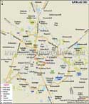
seum
- Jerosa Convent
- Rosario School
- Government College
- B G School
- Canara College
- Law College
- Padav School
- Women's Polytechnic College
- Kasturba Medical College (KMC)
- St Aloysius College
Last Updated on : May 11, 2026