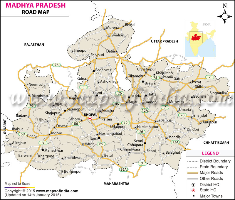
Madhya Pradesh Road Network
The state of Madhya Pradesh state houses an excellent roadways network which comprises national highways, state highways, district roads and other types of roads. It is home to 14 national highways spanning 4676 km and various state highways with an overall span of 8,728 km. The state is a trendsetter in the country in terms of execution of the Gramin Sadak Nirman Pariyojna, which is a plan supported by the Union Government to extend roadway networks to the villages. The table given below will give you an idea about the different types of roadways in Madhya Pradesh:
| B.T. | WBM | Class II | Total (in Km) | |
| State Highways | 5860 | 557 | 81.3 | 649930.00% |
| National Highways | 4676 | - | - | 467600.00% |
| Village Roads | 3560.2 | 13486.2 | 8321.8 | 2536820.00% |
| Major District Roads | 16566.8 | 12892.7 | 2056.3 | 3151580.00% |
The mean density of roadways in MP is 22.14 km per 100 sq km in comparison to the countrywide mean of 37 km.
State Highways in Madhya Pradesh
Given below is a list of the state highways in Madhya Pradesh along with their length:
| State highway No | Route | Length (in km) |
| MP SH 2 | Urai - Gopalpur (Uttar Pradesh) - Milhona - Ater - Porsa - Morena - Sabalgarh - Karoli - Till the boundary of Rajasthan | 247.2 |
| MP SH 1 | Mhow - Mandleshwar - Khargaon | 119.4 |
| MP SH 9 | Manikpur (Uttar Pradesh) - Rewa - Shahdol - Pandaria - Till the boundary of Chhatisgarh | 400.48 |
| MP SH 6 | Shivpuri - Sheopur - Sawai Madhopur - Till the boundary of Rajasthan | 143.6 |
| MP SH 10 | Ramanulganj (Chhatisgarh) - Jaisinghnagar - Barhi - Katni - Amanganj - Bijawar - Beldeogarh - traverses state boundary Border into UP - Tikamgarh (Uttar Pradesh)- Lalitpur (UP) - traverses state boundary in to Madhya Pradesh - Chanderi - Isagarh - Lukwasa - joins with National Highway 3 | 562.5 |
| MP SH 9 A | Shahdol - Amarkantak | 81.6 |
| MP SH 11 A | Seoni - Nainpur - Mandla | 72.8 |
| MP SH 11 | Gondia (Maharashtra) - Balaghat - Nainpur - Mandla Chabi - Shahpura - Umaria - Panpatha - Satna - Chitrakoot | 528.1 |
| MP SH 14 | Katni - Damoh - Sagar - Bina - Biaora Khilchipur - Jirapur - Susner (Rajasthan) - Mandsaur - Pratapgarh (Rajasthan) | 500.4 |
| MP SH 11 B | Chiraidongri - Kanha | 34 |
| MP SH 15 A | Sagar - Rehli | 42.2 |
| MP SH 15 | Sagar - Jaisinghnagar - Silwani - Bareli - Shahganj - Budhni - Hoshangabad - Harda - Ashapur - Kandwa | 362.9 |
| MP SH 19 | Jaithpur (Uttar Pradesh) - Mehgaon - Bhind - Seondha - Datia - Pichhor - Mungaoli - Kuwai - Vidisha - Salamtpur - Bareli - Chhiindwara - Nagpur (Maharashtra) | 743.4 |
| MP SH 18 | Bhopal - Sehore - Ashta - Dewas - Ujjain - Badnawar - Petlawad - Ahmedabad (Gujarat) | 362.3 |
| MP SH 22 | Sandalpur - Nasrullanganj - Hoshangabad - Piparia - Narsinghpur - Jabalpur - Dindori - Kabir Chabuthra (Chhattisgarh) | 530.1 |
| MP SH 19 A | Matkuli - Panchmarhi | 28 |
| MP SH 26 | Chipli (Chhattisgarh) - Balaghat - Seoni - Chhindwara - Multai - Betil - Khandwa - Khargone - Badwano - Alirajpur - Vadodara (Gujarat) | 692.2 |
| MP SH 23 | Sabalgarh - Birpur - Goras - Paron - Guna - Sironj - Bersia - Bhopal | 399.2 |
| MP SH 31 | Dhar - Khargaon - Bistan - Chiraiya - Padaliapal - Bhusawal (Maharashtra) - Lebad - Nagda - Ratlam - Jaora - Mandsaur - Neemuch - Nayagaon | 402.57 |
| MP SH 27 | Jhalawad (Rajasthan) - Agar - Ujjain - Indore - Mortakka - Chhaigaon - Burhanpur - Malkapur (Maharashtra) | 386.6 |
| MP SH 37 | Jhansi (Uttar Pradesh) - Orcha - Tikamgarh - Damoh - Jabalpur | 140.4 |
| MP SH 31 A | Neemuch - Manasa - Bhanpura - Jhalawad (Rajasthan) - Till the boundary of Madhya Pradesh | 50 |
| MP SH 37 | Jabalpur - Patan - Shahpura | 321.8 |
| MP SH 39 | Sendhwa - Badwani - Kukshi - Jobat - Jhabya - Thandia - Kushalgarh (Rajasthan) | 149 |
| MP SH 38 | Bandheri (National Highway 59) - Manwar - Khalghat - Maheshwar - Badwah | 145 |
| MP SH 40A | Dindori - Mandla - Lakhnadagon | 134.4 |
| MP SH 39 | Ratlam - Jhabua | 87 |
| MP SH 42 | Naktara - Dehgaon - Gairatganj - Beganganj - Rahatgarh - Khurai - Malthon | 160 |
| MP SH 41 | Kannod - Astha - Sujalpur - Sarangpur - Agar | 170 |
| MP SH 44 | Gairatgank - Silwani - Udaipura - Saikheda - Gadarwada | 85 |
| MP SH 45 | Mihona - Lahar - Bhandar (NH 25) - Till the boundary of Madhya Pradesh | 100 |
| MP SH 43 | Betul - Paratwada (Maharashtra) - Till the boundary of Madhya Pradesh | 67.8 |
| MP SH 49 | Damoh - Hata - Amanganj - Panna - Ajaygarh - Naraini (Uttar Pradesh) - Till the boundary of Madhya Pradesh | 165 |
| MP SH 47 | Chhindwara - Amarwada - Narsinghpur - Till National Highway 26 | 115 |
| MP SH 52 | Bela - Govindgarh - Rampur - Churhat | 63.5 |
| MP SH 51 | Sihora (National Highway 7) - Salaiya - Patera - Hata - Dargaon (National Highway 86) | 135 |
The overall span of the roadways network of the state of Madhya Pradesh is 68105.6 km.
National Highways in Madhya Pradesh
Given below are the 18 National Highways that pass through the state of Madhya Pradesh:
NH-7, NH-3, NH-12A, NH-12, NH-26, NH-25, NH-59, NH-27, NH-69, NH-59A, NH-75 Extension, NH-75, NH-78, NH-76, NH-86, NH-79, NH-86 Extension, and NH-92.
The national highways in Madhya Pradesh cover an overall span of 4676 km.
Last Updated on : May 12, 2026