|
||||||||||
 | ||||||||||
|





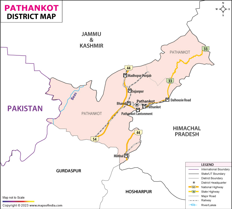
| *Pathankot District Map highlights the National Highways, Major Roads, District Headquarter, etc in Pathankot . |
Located where Punjab meets Himachal Pradesh and Jammu and Kashmir, Pathankot stands out across northern India's landscape - not just for views but also for access. Though small in size, its position shapes movement between flatlands and mountain edges. This junction funnels goods, people, and security operations through winding routes that lead deeper into high terrain. Over time, such placement turned it into a hub where commerce links with caution. Defense setups anchor here alongside market lanes, quietly supporting wider regional flows. Though small in size, Pathankot holds central importance as both administrative seat and primary urban node. Its role expands beyond governance due to strong transport networks reaching across northern regions by road and rail. Anyone bound for mountain resorts in Himachal Pradesh or sacred sites in Jammu and Kashmir typically moves through here. As a result, human traffic flows steadily, fueling local trade and daily economic rhythm without pause.
History & Culture
Across ages, Pathankot held strategic value due to its role as a junction between northern plains and mountainous zones. Because of the location of the district, there has been a constant flow of people in the past that has shaped the local life.
Back then, the area around Pathankot shifted between multiple realms and rulers across centuries. Riverside spots drew early habitation thanks to rich soil good for crops. Farming stood central to life, along with tending livestock and exchanging goods through commerce. Power shifts and warfare reshaped how the region evolved in later phases.
Though quiet at first glance, Pathankot gained prominence through medieval times due to where it sat on the map. Because it linked lowlands to highland zones, various local powers saw an advantage in holding its passes. Over time, governance and troop activity centered here began steering changes across northern India.
Backed by colonial priorities, transport networks grew across the region. Thanks to rail projects, Pathankot gained importance in regional commerce while linking plains and highlands more effectively. As new roads reached nearby territories, exchange of goods and movement of people picked up pace. Owing to its location, the area saw steady growth in military facilities over time.
After India won independence, Pathankot grew in significance due to shifting defense needs. Over time, armed forces infrastructure expanded here, shaping much of the region's character. Located near volatile frontiers and strategic northern zones, its place in safeguarding national interests deepened. Its border adjacency quietly cemented a lasting military presence.
Fresh rhythms shape Pathankot’s culture through layered regional traces. While Punjabi roots hold strong ground, touches from Himachal Pradesh and Jammu add quiet variety below the surface. Speech flows one way during harvest, another at temple fairs. Meals carry spice trails from mountain valleys, sometimes meeting flatbreads baked in village ovens. Fabric choices shift with seasons, echoing colors seen beyond borders. Celebration times blur lines - rituals start familiar, then twist into something newly shared.
Still today, music shapes much of how people celebrate across Punjab. Whether through lively Bhangra routines or age-old wedding customs, sound and movement bring folks together. During festival events, stages fill with dancers showing styles passed down for generations. Songs sung by elders echo at gatherings where younger ones listen and learn. Local art thrives most when rooted in shared moments like these.
Most meals in Pathankot center on wheat flatbreads, shaped by Punjabi roots alongside flavors from nearby hills. Dairy items appear regularly, often paired with stuffed parathas made fresh each morning. Seasonal produce finds its way into many plates, bringing variety through changing months. Lassi, thick and cooling, is a daily staple across age groups. Traditional Punjabi recipes stay common, passed down without fanfare. Street vendors and small eateries shape much of how people connect around eating. Market stalls bustle throughout daylight hours, offering more than just ingredients - they host chats, greetings, shared moments.
Among Indian districts, few blend flatland farming culture with hill heritage quite like Pathankot does. Shaped by Punjabi sowing and reaping customs, its roots stretch into highland zones too. Generations here grew up amid valley rhythms, yet kept step with lowland routines. Not many places hold both soil types - fertile fields below, rugged slopes above - and live fully in each.
Economy
Transport services help shape Pathankot’s economic base, while defense installations contribute steady employment. Farming remains a key part of daily life here, followed closely by local markets that thrive on movement of goods. Tourism adds seasonal income, boosted slightly by improved access routes. Urban centers now host more shops, offices, rising alongside traditional sectors without replacing them.
Farming still shapes life in country regions. While wheat and corn take center stage, other plants fill out the harvest picture. Alongside them grow sugar cane, greens, animal feed, and staple grains. Where soil runs rich and water flows steady, fields thrive under open skies.
Farmers often earn extra by raising cows alongside crops. Alongside these activities, small-scale animal husbandry supports household finances. Village markets play a role too, linking farmers to buyers nearby. Local trade hubs help circulate money within rural areas. These networks strengthen economic resilience quietly.
Government Sector
Among public entities, district offices stand alongside hospitals, educational facilities, law enforcement units, armed forces installations, and social support programs in shaping community infrastructure. Jobs emerge not only within military operations but also across linked industries and supply networks.
Public Sector
State-run banks, transit networks, schools, hospitals, and agencies handling construction projects help boost economies. In similar fashion, military-linked facilities add to government-driven financial output.
Services Sector
Among Pathankot’s key economic strengths lies its diverse service industry. Urban areas see steady job creation through hospitality units, eateries, shops, transit operators, supply chain providers, schools, and medical clinics. Employment spreads widely where people gather, sustained by daily demand.
Local workshops handling wood, making basic foods, fixing equipment, producing building supplies, or crafting goods add value to the economy. Visitors drawn to sacred places nearby boost business for eateries, inns, along forested mountain paths. Local shops gain activity when pilgrims pass through scenic highland trails.
Tourism
Gazing upon Pathankot, one finds faith etched in temples and shrines. Lush landscapes roll across the terrain, drawing eyes outward. Old forts whisper stories of past eras. Hill areas sit close by, reachable within short travel. Journeys here unfold without long distances to cover.
Perched amid quiet hills, Mukteshwar Temple ranks among the region’s top spiritual sites. Revered as a shrine to Lord Shiva, it attracts travelers seeking reverence or simply calm views. Though rooted in devotion, its appeal stretches beyond ritual - natural beauty plays its part too. Few places blend mountain air so closely with sacred stillness.
Among regional highlights stands the Ranjit Sagar Dam. Located along the Ravi River, it holds back a stretch of water framed by rolling hills and dense foliage. Travelers drawn to open spaces and natural settings often find their way here. Scenery dominates the experience, shaping much of what visitors remember afterward. Built under earlier systems of rule and defense, it carries traces of past strategic needs. Its walls speak less of noise now, more of endurance through shifting times. Even without active use, the structure helps shape how people remember the region’s past.
Demographics
With roughly 6.7 lakh residents, Pathankot district spans cities and farmland alike - Census 2011 reveals its makeup clearly. Though bustling markets rise in towns, wide stretches grow crops where families live off the land. Punjabi holds the lead as the top language spoken in the region. In official settings and schools, Hindi appears regularly instead. Some neighborhoods favor Dogri along with local speech forms more often. These variations appear depending on where one travels within the boundaries.
With around 84% of residents able to read and write, Pathankot ranks among Punjab's more advanced areas in education. Progress has come through growth in schools and higher institutions, alongside city development in the past few decades. Farming traditions, along with movement of people within the region, help define everyday life in these towns. Military presence has left its mark on local customs over time. Exchange of goods plays a role in shaping shared habits. Cultural variety emerges through layers of historical change.
Administration
Running across its territory, Pathankot district organizes work via administrative divisions alongside locally rooted governance bodies. These units handle tasks tied to growth, oversight, and delivery of civic services. Each level operates with defined roles shaping how decisions move from policy into practice. Coordination between tiers affects outcomes in planning and resource use. Governance here relies on structured frameworks yet adapts to regional demands. Located at the heart of the region, Pathankot holds responsibility for district governance. Its role extends beyond administration into coordination of local services.
Among the main subdivisions are Pathankot, followed by Dhar Kalan, while Narot Jaimal Singh also holds significance. Beyond four hundred settlements dot the landscape, scattered through farmland, patches of woodland, among pockets nearing urban form. Villages appear where crops grow, trees thicken, spaces blur between rural and developed edges. Spread unevenly, these communities occupy terrain shaped by farming needs, natural cover, shifting settlement patterns. Each zone holds clusters - some tucked into green stretches, others near roads feeding small market centers. Distribution follows land use, not uniform design, revealing how the environment guides habitation choices.
Sanitation efforts emerge through the combined work of the community, shaping cleaner environments over time. Health programs reach residents because these groups coordinate delivery on the ground. Roads take form where both entities align priorities. Infrastructure grows quietly under shared responsibility, step by gradual step. Welfare reaches farther when decisions stay close to people.
Transport management stands first among administrative goals, followed by efforts in rural growth. Education comes alongside improved access to medical care. Defense matters link closely with national security planning. Environmental protection receives steady attention across policy levels.
| Official Name | Pathankot |
| Location | Punjab |
| Area | 929 sq. km |
| Population | 626154 |
| Language | Punjabi, Hindi |
FAQs
Q1: How many villages are there in the district?
There are 462 villages in the district.
Q2: What is the population of Pathankot district?
According to the 2011 census, the population of the district is 626154.
Q3: What is Pathankot famous for?
Pathankot is situated at the junction where Punjab meets Himachal Pradesh and touches Jammu and Kashmir. This makes it an ideal place for tourists who travel across these regions. Places like Chamba, Dharamshala, Mcleodganj, and remote temples draw people forward after a night’s stay.
Last Updated on : July 10, 2026
