About Agra Metro
Agra is globally renowned for the presence of the majestic monument "Taj Mahal". It is the fifth largest city in the state of Uttar Pradesh in India. The Detailed Project Report (DPR) of Agra Metro Rail was submitted to Agra Development Authority in the December end. The construction of Metro in Agra is soon going to take place in March 2018. The project was made by the engineering consultancy firm Rail India Technical and Economic Service (RITES).
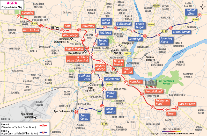
It is expected that Agra will likely get two metro routes. The complete metro line will be stretched to thirty kilometres. The line 1 will be the red line and Line 2 will be blue line. The Line 1 will start from Sikandara to Taj East Gate (6.4 kilometres is expected to be elevated and 7.6 kilometres is expected to be underground). The Line 2 will be stretched from Agra Cantt to Kalindi Vihar ( completely elevated). Some of the major stations to be built include Taj Mahal East gate, Agra Fort, Jama Masjid, Heeng Ki Mandi, Raja Mandi, Guru Ka Taal and ISBT in Line 1. Major stations of Line 2 are Sadar Bazaar, Pratapura, St John's crossing, Subhas Park, Kamlanagar, and Rambagh.
According to the reports of DPR, the three coach trains will make 136 trips in a day. A lot of structures will be affected due to this metro construction.
The total length of the metro routes will be around 25 kilometres and the estimated cost is Rupees 200 crore for elevated metro stations and Rupees 450 Crore for underground stations. Around 210 acres of land would be altogether needed for the construction of the metro.
Last Updated on : January 14, 2026
