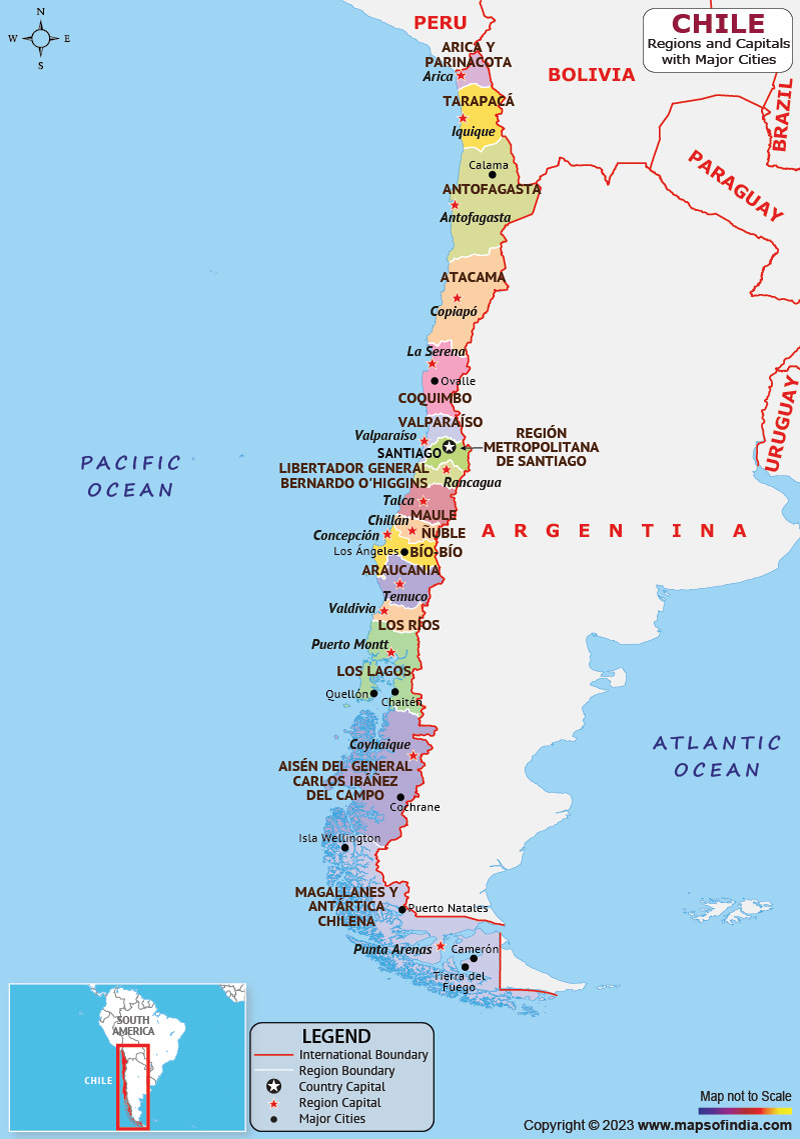
Chile is located in western South America and is the southernmost country in the world. It is located close to Antarctica. The borders of Chile are connected with Peru in the north, the Drake Passage to the south, Argentina to the east and Bolivia to the northeast. The capital of Chile is Santiago and it is also its largest city. Chile has a high-income economy and is one of the most socially and economically stable nations in South America.
History:
Spain conquered and colonized the region in the mid-16th century, replacing Inca rule, but it failed to conquer the independent Mapuche people in what is now south-central Chile. After declaring independence from Spain in 1818, and in the 1830s Chile emerged as a relatively stable authoritarian republic.
After declaring independence from Spain in 1818, Chile emerged as a relatively stable autocratic republic in the 1830s. Mapuche resistance was put to an end in the 1880s when in the 19th century Chile experienced territorial and economic growth. Chile underwent a process of democratization and experienced urbanization and rapid population growth until the 1970s. The country relied on exports from copper mining for its economy. During the 1960s and 1970s, severe left-right political polarization was faced by the country which was followed by a 16-year right-wing military dictatorship. Following a referendum in 1988, the regime ended in 1990.
Culture:
From early agricultural settlements to the late pre-Columbian period, northern Chile was a region of Andean culture, influenced by the Altiplano traditions that prevailed in the coastal valleys of the north, and the southern region of Mapuche cultural activity. The country’s culture was dominated by the Spanish during the early Republican period.
Language:
Unlike neighboring South American countries, the Spanish spoken in Chile is distinctively accented, as some consonants have a soft pronunciation and final syllables are often dropped. The emphasis shifts very slightly from north to south. Depending on social class or whether you live in the city or the countryside, the difference in accent is more noticeable. There are various indigenous languages spoken in Chile such as Aymara, Mapudungun, Rapa Nui, Qawasqar, Chilean Sign Language and Yaghan.
Geography:
Chile is situated on the west side of the Andes mountains. It is a long and narrow coastal Southern cane country. It encompasses a remarkable variety of landscapes and climates and is situated within the Pacific Ring of Fire. It stands as one of the longest north-south countries in the world. Considering only the mainland, Chile is unique in that it is narrow in the east-west direction in this group, along with other countries that are long in the north-south direction.
| Official name | Republican of Chile |
| Capital | Santiago |
| Population | 1.95 crores (2021) |
| Area | 756,950 sq km |
| Currency | Chilean Peso |
| Religion | Christianity and Roman Catholic |
| Language | Spanish |
| Major cities | Santiago, Puente Alto, Antofagasta |
FAQs
Q.1. When did Chile get independence from the Spanish?
Ans. Chile became independent from Spanish rule on September 18, 1810.
Q.2. Where is Chile located?
Ans. The country is located along a highly volcanic and seismic zone which is part of the Pacific Ring of Fire.
Q.3. What is Chile’s climatic condition?
Ans. Chile's climate varies from the Atacama Desert, the world's driest desert in the north, to the Mediterranean climate in the center, the humid subtropical climate of Easter Island, and the oceanic climate.
Last Updated on: July 08, 2025
