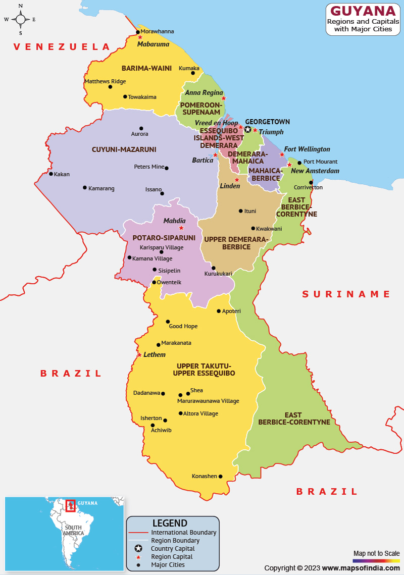
Guyana, officially known as the Cooperative Republic of Guyana has an area of 215,000 km2, making it the third-smallest sovereign state in South America's mainland. It is also the second-least populous sovereign state in the continent, and one of the least densely populated nations on Earth. It is biodiverse and has a wide range of natural habitats.
Georgetown serves as the capital. The shield-shaped landmass also referred to as the "land of many glasses of water," is commonly referred to as "the Guianas." The Wai Wai, Macushi, Lokono, Kalina, Wapishana, Pemon, Akawaio, and Warao are nine of Guyana's indigenous tribes.
History:
The British took over Guyana in the late 18th century after the Dutch colonized it. Until the 1950s, British Guiana governed it, with an economy based on plantations. As a republic within the Commonwealth of Nations, it gained independence in 1966. In 1975–76 and later in 1982–83, Guyana won two elections to the UN Security Council.
Culture:
Guyana's culture emerged due to immigrants' adaptations to and convergence with the prevailing British culture, both forced and willingly. Indian immigrants experienced less assimilation due to their late arrival and slightly more favorable circumstances, which allowed them to preserve more of their culture's distinctive traditions, food, music, and festivals. Its mixture of the dominant Indo-Guyanese and Afro-Guyanese cultures sets it apart from other regions of the Americas. In terms of food, celebrations, music, sports, etc., Guyana and the West Indies islands have a lot in common.
Language:
Guyana is the only country in South America where English is a primary language. Guyana has a large Guyanese Creole-speaking population. Some Indo-Guyanese continue to speak Guyanese Hindustani for cultural and religious reasons. Guyanese Bhojpuri may be used in folk songs, by older generations, or in a limited capacity at home.
A small portion of the population also speaks several Amerindian languages. These include Cariban languages like Macushi, Akawaio, and Wai-Wai and Arawakan languages like Arawak and Wapishana.
Geography:
It is located in Northern South America and part of Caribbean South America, bordering the North Atlantic Ocean, between Suriname and Venezuela, and has a total land area of roughly 214,969 square kilometers. The nation is located between 1 and 9 north latitudes and 56 and 62 west longitude. Guyana borders Venezuela on the west. It also borders Brazil on the west and south, and Suriname on the east. It has a 459 km (285 mi) long Atlantic coastline on the northeast. More than 90% of the population lives in the coastal plain, which makes up about 5% of the country's total area. Water is in abundance in Guyana. Many rivers enter the Atlantic Ocean, usually in a northerly direction.
| Official Name | Co‑operative Republic of Guyana |
| Capital | Georgetown |
| Population | 808726 |
| Area | 214,969 km² |
| Currency | Guyanese Dollar |
| Religion | Christianity and Hinduism |
| Language | English |
| Major Cities | Georgetown,New Amsterdam,Linden |
FAQs
Q1: What is the official language of Guyana?
English is the official language of Guyana.
Q2: What is the capital of Guyana?
Georgetown is the capital of Guyana.
Q3: What is the currency of Guyana?
Guyanese Dollar is the currency of Guyana
Q4: What is the climate in Guyana?
Guyana enjoys a wet tropical climate with warm temperatures and abundant rainfall. Temperature ranges from 16°C and 34°C with low temperature at high areas.
Last Updated on: July 09, 2025
