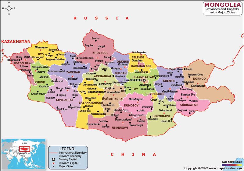
Mongolia is an East Asian country, which shares its borders with China to the south and Russia to the north. Mongolia is the world's largest landlocked country and is not bordered by closed seas. Most of the country is surrounded by grasslands, with mountains to the north and west and the Gobi Desert to the south.
History:
Various nomadic empires ruled the territory of modern-day Mongolia. The Mongol empire was founded by Genghis Khan in 1206. In the 16th century, Tibetan Buddhism spread to Mongolia under the leadership of the Manchu Qing Dynasty, which engulfed the country in the 17th century. After this Mongolia declared independence. The actual independence from the Republic of China came in 1921.
In 1924, a socialist state, the Mongolian People's Republic, was founded. After an anti-communist revolution in 1989, Mongolia staged a peaceful democratic revolution in the early 1990s. The democratic revolution led to a multiparty system, a transition to a market economy, and a new constitution in 1992.
Culture:
Soyombo, a symbol in the left bar of the national flag of Mongolia, represents the moon, stars, sun, and heavens per standard cosmological symbology that are seen in traditional thangka paintings. Until the 20th century, most Mongolian visual arts had a religious function, so Mongolian visual arts were heavily influenced by religious texts. The music here is influenced by nomadism, nature, Tibetan Buddhism, and shamanism. Traditional music includes a variety of instruments known as morin khuur and singing styles such as urtyn duu and throat singing.
Language:
Mongolian is the official language of Mongolia and is spoken by a large population. Various dialects of Oirat and Buryat are spoken throughout the country, and there are also speakers of Mongolian Kamnigan. Kazakh and Tuban are also spoken in the western regions, both of which are Turkic. Mongolian Sign Language is the primary language of the deaf community. Russian is the most widely spoken foreign language in Mongolia, followed by English, but English is slowly replacing Russian as a second language.
Geography:
Mongolia's geography is diverse. It is the Gobi Desert in the south and cold mountainous regions in the north and west. Most of Mongolia consists of forested Mongol-Manchurian pasture steppes. Mongolia lies between longitudes 87 degrees and 120 degrees east, and latitudes 41 degrees and 52 degrees north.
| Official name | Mongolia |
| Capital | Ulaanbaatar |
| Population | 33.5 lakhs |
| Area | 1.564 million sq km |
| Currency | Mongolian Tugrik |
| Religion | Buddhist |
| Language | Mongolian |
| Major cities | Ulaanbaatar, Erdenet, Darkhan |
FAQs
Q.1. What does the symbol on the flag of Mongolia represent?
Ans. Soyombo, a symbol in the left bar of the national flag of Mongolia, represents the moon, stars, sun, and heavens per standard cosmological symbology that are seen in traditional thangka paintings.
Q.2. What is the currency of Mongolia?
Ans. mongolian Tugrik is the currency of Mongolia.
Last Updated on: July 09, 2025
