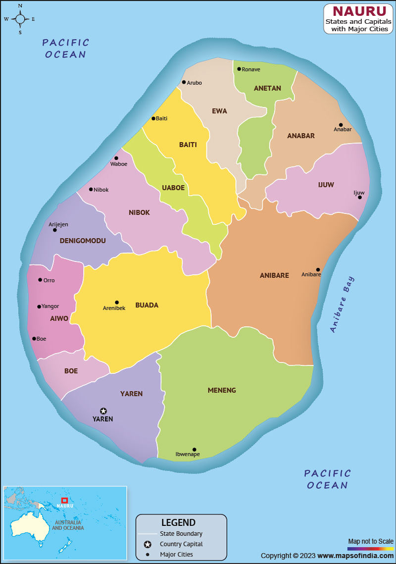
Nauru, officially known as the Republic of Nauru, is a sovereign state situated in the Pacific Ocean. The country is known for its distinctive landscape, which includes jagged limestone cliffs, white sand beaches, and coral reefs. Nauru is also known for its phosphate mining industry, which has been a major contributor to the country's economy.
History:
Nauru has a long and complex history that dates back thousands of years. The island was first settled by Polynesian and Micronesian voyagers, who established a culture based on subsistence farming, fishing, and the cultivation of pandanus and coconut trees. In the 19th century, Nauru became a focus of interest for European powers, particularly Germany and Britain. The island was eventually annexed by Germany in 1888 and became a colony of the German Empire. During World War I, Nauru was occupied by Australian forces, and after the war, it was placed under the control of the League of Nations. Nauru gained independence in 1968.
Culture:
Nauru has a unique and distinct culture that is deeply rooted in traditional practices and beliefs. The country's population is primarily made up of Nauruans, who are of mixed Polynesian and Micronesian ancestry. One of the most important cultural practices in Nauru is the buka, which is a traditional feast that is held to mark important events such as weddings, funerals, and other celebrations. The country is also known for its traditional dance and music, which is performed using a variety of instruments such as drums and bamboo flutes.
Language:
The majority language of Nauru is Nauruan, which is a Malayo-Polynesian language that is closely related to other languages spoken in Micronesia and Polynesia. English is also widely spoken and is used in schools, government, and business settings.
Geography:
Nauru is a raised coral atoll, with a central plateau that is surrounded by a narrow coastal plain. The island's landscape is dominated by jagged limestone cliffs, which rise up to 70 meters (230 feet) in some areas. The country is also surrounded by coral reefs, which are home to a diverse range of marine life.
Nauru's geography has had a significant impact on the country's economy and way of life. The country's phosphate deposits were formed over millions of years through the accumulation of bird droppings on the island's ancient coral reefs. The mining of phosphate became a major industry in the 20th century, and it has been a significant source of revenue for the country. However, the mining has also had significant environmental and social impacts, including the depletion of the island's natural resources and the displacement of indigenous communities.
| Official Name | Republic of Nauru |
| Capital | None |
| Population | 10384 |
| Area | 21 km2 |
| Currency | Australian Dollar |
| Religion | Christianity |
| Language | Nauruan, English |
| Major Cities | Denigomodu |
FAQs
Q1: What is the population of Nauru?
The estimated population of Nauru is around 10,000 people.
Q2: What is the main industry in Nauru?
Nauru's economy is heavily dependent on phosphate mining, which has caused significant environmental damage to the island.
Q3: Is Nauru a tourist destination?
Nauru is not a popular tourist destination due to its small size, lack of tourist infrastructure, and limited attractions.
Q4: What is the political system of Nauru?
Nauru is a parliamentary democracy with a president as the head of state and a unicameral parliament.
Last Updated on: July 09, 2025
