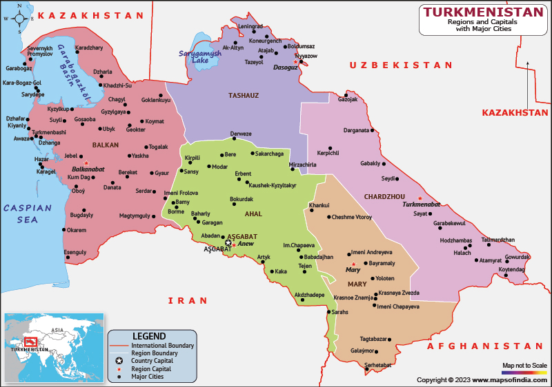
Turkmenistan is a Central Asian country which shares its borders with Uzbekistan to the north, northeast and east, Kazakhstan to the northwest, the Caspian Sea to the west, and Iran to the southwest and south.
History:
Russian troops began occupying Turkmen territories at the end of the 19th century. At the Caspian Sea base in Krasnovodsk, Russian forces eventually defeated the Khanate of Uzbekistan. In 1881, the last significant resistance to the Turkmen territories was crushed at the Battle of Geok-Tepe, shortly thereafter Turkmenistan was annexed to the Russian Empire along with the neighbouring Uzbek territories.
The Russian Revolution of 1917 had no direct effect. In the 1920s, Turkmen forces joined Kazakhs, Uzbeks and Kyrgyz in the Basmachi uprising against the rule of the Soviet Union. For the next half century, Turkmenistan played an economic role within the USSR and was removed from the loop of major world events. On December 26, 1991, the Soviet Union ceased to exist. Niyazov went on to replace communism as Turkmenistan's head of state with a unique brand of independent nationalism bolstered by a pervasive cult of personality.
Culture:
The Turkmen have traditionally been nomads and cavalrymen, and even today, attempts to urbanize the Turkmen after the collapse of the Soviet Union have been unsuccessful. They are divided into clans, each with its own dialect and clothing style. The Turkmen are famous for making knotted Turkmen carpets, often mistakenly called Bukhara carpets in the West. These are intricate and colorful handmade carpets that help point out the differences between the various Turkmen clans. Turkmen men wear the traditional telpek. A large black or white sheepskin hat. The traditional male attire consists of a long, bushy sheepskin hat and a red robe over a white shirt. Women wear loose long dresses over tight trousers.
Language:
The official language of Turkmenistan is Turkmen. Beginning in the late 20th century, Turkmen governments took steps to distance themselves from the Russian language. The languages spoken in Turkmenistan include Turkmen, Uzbek, Russian, Tatar, Azerbaijani, etc.
Geography:
Turkmenistan is the 52nd largest country in the world. It lies between longitudes 52 degrees and 67 degrees East and latitudes 35 degrees and 43 degrees N. The center of the country is dominated by the Karakum Desert and the Turan Depression. Topographically, the country is bounded by the Kopet Dag Range to the south, the Paropamyz Plateau, the Ustyurt Plateau to the north, the Koytendag Range to the east, the Caspian Sea and the Amu Darya valley to the west. Major rivers of the country include the Murghab river, the Amu Darya, the Atrek river and the Tejen River.
| Official name | Turkmenistan |
| Capital | Ashgabat |
| Population | 63.4 lakhs (2021) |
| Area | 488,099 sq km |
| Currency | Turkmenistani Manat |
| Religion | Muslim |
| Language | Turkmen |
| Major cities | Ashgabat, Turkmenabat, Mary, tejan |
FAQs
Q.1. What is the climatic condition of Turkmenistan?
Ans. It is located in a temperate desert region with a dry continental climate.
Q.2. When did Turkmenistan declare its independence?
Ans. Turkmenistan declared its independence on October 27, 1991.
Q.3. What is the capital of Turkmenistan?
Ans. The largest city and capital of Turkmenistan is Ashgabat.
Last Updated on: July 08, 2025
